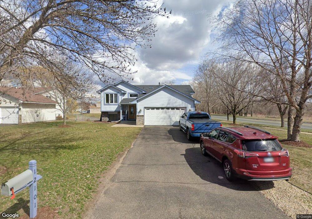
12101 Martin St NW Coon Rapids, MN 55448
Estimated Value: $366,000 - $407,000
4
Beds
2
Baths
2,488
Sq Ft
$158/Sq Ft
Est. Value
About This Home
This home is located at 12101 Martin St NW, Coon Rapids, MN 55448 and is currently estimated at $392,091, approximately $157 per square foot. 12101 Martin St NW is a home located in Anoka County with nearby schools including Lucile Bruner Elementary School, Hoover Elementary School, and Laughlin Junior/Senior High School.
Ownership History
Date
Name
Owned For
Owner Type
Purchase Details
Closed on
Apr 30, 2021
Sold by
Weddel Barbara J Byram
Bought by
Annis Aly and Calixte Patricia
Current Estimated Value
Home Financials for this Owner
Home Financials are based on the most recent Mortgage that was taken out on this home.
Original Mortgage
$294,566
Outstanding Balance
$266,533
Interest Rate
3%
Mortgage Type
FHA
Estimated Equity
$125,558
Purchase Details
Closed on
May 25, 2001
Sold by
Maass Leroy J
Bought by
Weddel Barbara J Byram
Create a Home Valuation Report for This Property
The Home Valuation Report is an in-depth analysis detailing your home's value as well as a comparison with similar homes in the area
Home Values in the Area
Average Home Value in this Area
Purchase History
| Date | Buyer | Sale Price | Title Company |
|---|---|---|---|
| Annis Aly | $300,000 | Results Title | |
| Weddel Barbara J Byram | $188,500 | -- |
Source: Public Records
Mortgage History
| Date | Status | Borrower | Loan Amount |
|---|---|---|---|
| Open | Annis Aly | $294,566 |
Source: Public Records
Tax History Compared to Growth
Tax History
| Year | Tax Paid | Tax Assessment Tax Assessment Total Assessment is a certain percentage of the fair market value that is determined by local assessors to be the total taxable value of land and additions on the property. | Land | Improvement |
|---|---|---|---|---|
| 2025 | $3,785 | $363,600 | $81,700 | $281,900 |
| 2024 | $3,785 | $360,100 | $90,300 | $269,800 |
| 2023 | $3,469 | $354,900 | $77,900 | $277,000 |
| 2022 | $3,137 | $353,500 | $66,500 | $287,000 |
| 2021 | $3,075 | $287,100 | $53,100 | $234,000 |
| 2020 | $3,089 | $275,500 | $56,700 | $218,800 |
| 2019 | $2,903 | $265,800 | $60,300 | $205,500 |
| 2018 | $2,705 | $244,300 | $0 | $0 |
| 2017 | $2,446 | $222,600 | $0 | $0 |
| 2016 | $2,452 | $196,800 | $0 | $0 |
| 2015 | -- | $196,800 | $51,000 | $145,800 |
| 2014 | -- | $179,000 | $50,300 | $128,700 |
Source: Public Records
Map
Nearby Homes
- 1727 121st Ln NW
- 12365 Jay St NW
- 2068 124th Ln NW
- 12010 Eagle St NW
- 2147 125th Ln NW
- 1449 119th Ln NW
- 12463 Drake St NW
- 1660 Northdale Blvd NW
- 12554 Grouse St NW
- 1930 127th Cir NW
- 1593 126th Ln NW
- 11444 Hanson Blvd NW
- 11424 Hanson Blvd NW
- 12760 Raven St NW
- 1450 126th Ln NW
- 11852 Yellow Pine St NW
- 11350 Jay St NW
- 12019 Zion St NW
- 11409 Quinn St NW
- 12759 Ibis St NW
- 12109 Martin St NW
- 12117 Martin St NW
- 12100 Martin St NW
- 12114 Martin St NW
- 1883 1883 121st Ln NW
- 1883 1883 121st-Lane-nw
- 12125 Martin St NW
- 12128 Martin St NW
- 12133 Martin St NW
- 1883 121st Ln NW Unit 912
- 1883 121st Ln NW Unit 911
- 1883 121st Ln NW Unit 910
- 1883 121st Ln NW Unit 909
- 1883 121st Ln NW Unit 908
- 1883 121st Ln NW Unit 907
- 1883 121st Ln NW Unit 906
- 1883 121st Ln NW Unit 905
- 1883 121st Ln NW Unit 904
- 1883 121st Ln NW Unit 903
- 1883 121st Ln NW Unit 902