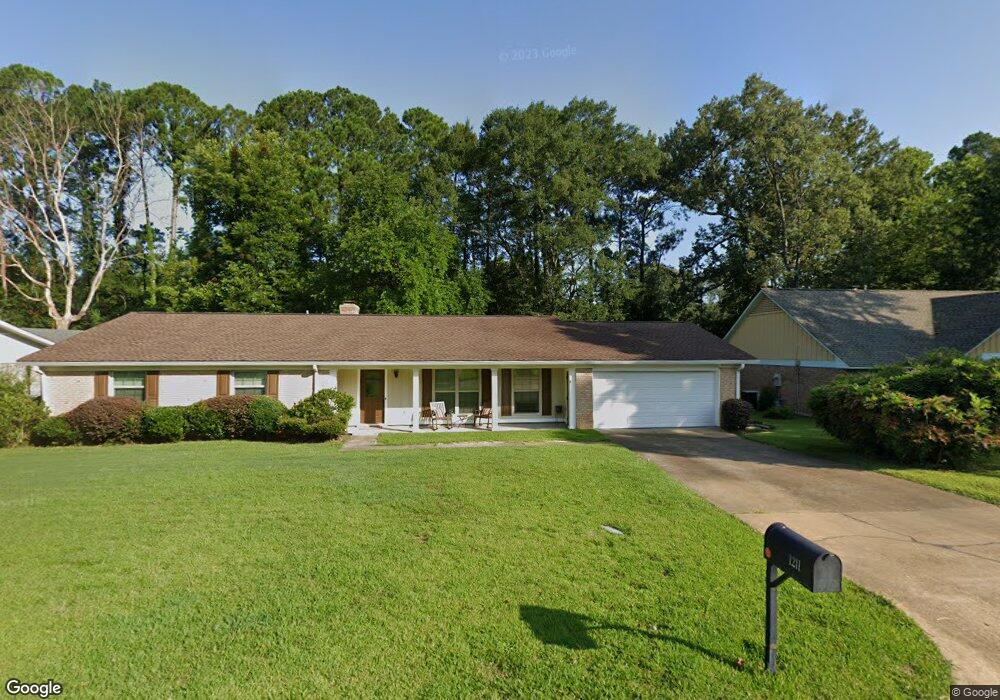
1211 Huntcliff Way Clinton, MS 39056
Estimated Value: $220,000 - $241,000
4
Beds
2
Baths
2,100
Sq Ft
$110/Sq Ft
Est. Value
About This Home
This home is located at 1211 Huntcliff Way, Clinton, MS 39056 and is currently estimated at $230,305, approximately $109 per square foot. 1211 Huntcliff Way is a home located in Hinds County with nearby schools including Clinton Park Elementary School, Eastside Elementary School, and Northside Elementary School.
Ownership History
Date
Name
Owned For
Owner Type
Purchase Details
Closed on
Oct 6, 2009
Sold by
Watson Dayna L
Bought by
Neely Robert F and Neely Beth B
Current Estimated Value
Home Financials for this Owner
Home Financials are based on the most recent Mortgage that was taken out on this home.
Original Mortgage
$108,900
Outstanding Balance
$71,219
Interest Rate
5.11%
Estimated Equity
$159,086
Create a Home Valuation Report for This Property
The Home Valuation Report is an in-depth analysis detailing your home's value as well as a comparison with similar homes in the area
Home Values in the Area
Average Home Value in this Area
Purchase History
| Date | Buyer | Sale Price | Title Company |
|---|---|---|---|
| Neely Robert F | -- | -- |
Source: Public Records
Mortgage History
| Date | Status | Borrower | Loan Amount |
|---|---|---|---|
| Open | Neely Robert F | $108,900 |
Source: Public Records
Tax History Compared to Growth
Tax History
| Year | Tax Paid | Tax Assessment Tax Assessment Total Assessment is a certain percentage of the fair market value that is determined by local assessors to be the total taxable value of land and additions on the property. | Land | Improvement |
|---|---|---|---|---|
| 2025 | $1,172 | $9,590 | $2,500 | $7,090 |
| 2024 | $1,172 | $9,590 | $2,500 | $7,090 |
| 2023 | $1,172 | $9,590 | $2,500 | $7,090 |
| 2022 | $1,458 | $9,590 | $2,500 | $7,090 |
| 2021 | $1,158 | $9,590 | $2,500 | $7,090 |
| 2020 | $1,134 | $9,498 | $2,500 | $6,998 |
| 2019 | $1,163 | $9,498 | $2,500 | $6,998 |
| 2018 | $1,163 | $9,498 | $2,500 | $6,998 |
| 2017 | $1,108 | $9,498 | $2,500 | $6,998 |
| 2016 | $1,108 | $9,498 | $2,500 | $6,998 |
| 2015 | $1,072 | $9,285 | $2,500 | $6,785 |
| 2014 | $1,072 | $9,285 | $2,500 | $6,785 |
Source: Public Records
Map
Nearby Homes
- 603 Herndon Hill
- 0 Huntcliff Way
- 605 Herndon Hill
- 1221 Huntcliff Way
- 1219 Canterbury Ln
- 504 Hampton St
- 1200 Canterbury Ln
- 102 Friars Cove
- 1422 Huntcliff Way
- 317A Avondale Dr
- 809 Normandy Dr
- 1206 Shady Glen Dr
- 1203 Rockingham Dr
- 00002 E Northside Dr
- 00001 E Northside Dr
- 1000 E Northside Dr
- 1011 Laurelwood Dr
- 1301 Beverly Dr
- 1200 Tanglewood Dr
- 149 Navajo Cir
- 1213 Huntcliff Way
- 1209 Huntcliff Way
- 1206 Huntcliff Way
- 1208 Huntcliff Way
- 1207 Huntcliff Way
- 1204 Huntcliff Way
- 1210 Huntcliff Way
- 1215 Huntcliff Way
- 1212 Foxhill Dr
- 1214 Foxhill Dr
- 602 Herndon Hill
- 1205 Huntcliff Way
- 1216 Foxhill Dr
- 1210 Foxhill Dr
- 1202 Huntcliff Way
- 1218 Foxhill Dr
- 1217 Huntcliff Way
- 1208 Foxhill Dr
- 605 Hampton Cove
- 1203 Huntcliff Way