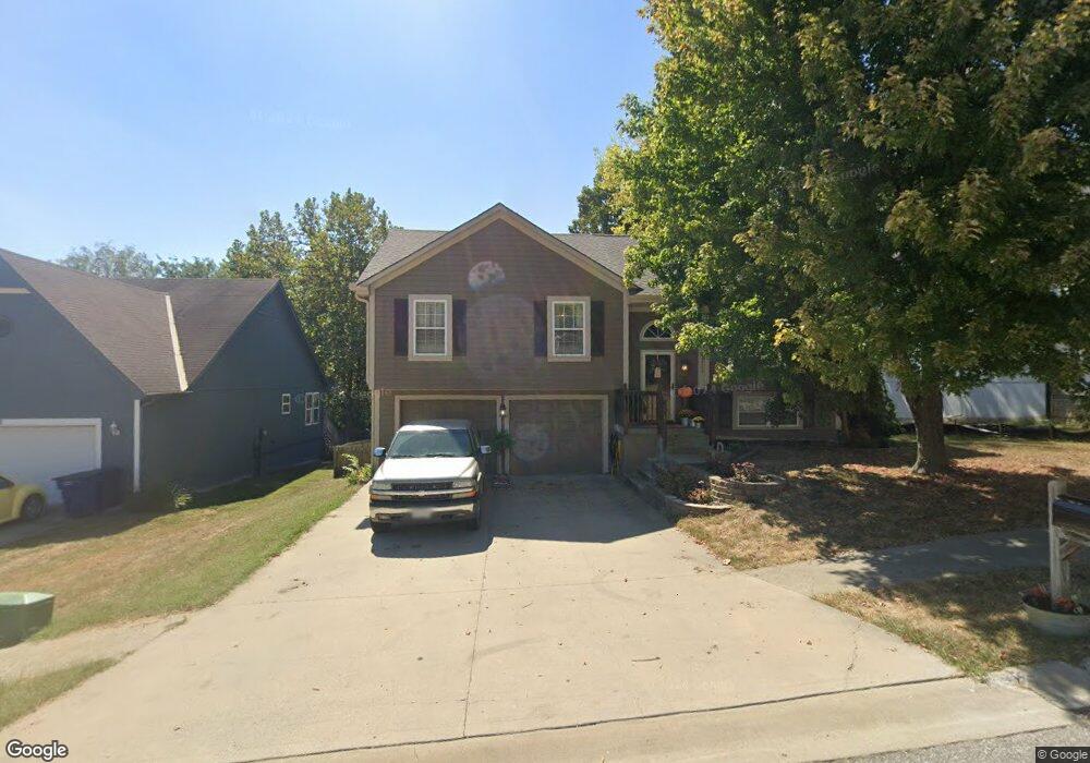
1213 SW Graystone Dr Grain Valley, MO 64029
Estimated Value: $292,575 - $329,000
3
Beds
2
Baths
1,312
Sq Ft
$238/Sq Ft
Est. Value
About This Home
This home is located at 1213 SW Graystone Dr, Grain Valley, MO 64029 and is currently estimated at $312,894, approximately $238 per square foot. 1213 SW Graystone Dr is a home located in Jackson County with nearby schools including Grain Valley High School.
Ownership History
Date
Name
Owned For
Owner Type
Purchase Details
Closed on
Jul 20, 2009
Sold by
Bartlett Donald T
Bought by
Bartlett Anne
Current Estimated Value
Purchase Details
Closed on
Dec 22, 1999
Sold by
Colson Construction Inc
Bought by
Bartlett Donald Travis and Bartlett Anne M
Home Financials for this Owner
Home Financials are based on the most recent Mortgage that was taken out on this home.
Original Mortgage
$86,400
Outstanding Balance
$26,741
Interest Rate
7.71%
Mortgage Type
Construction
Estimated Equity
$286,153
Purchase Details
Closed on
Dec 17, 1999
Sold by
Ward Development & Investment Co
Bought by
Colson Construction Inc
Home Financials for this Owner
Home Financials are based on the most recent Mortgage that was taken out on this home.
Original Mortgage
$86,400
Outstanding Balance
$26,741
Interest Rate
7.71%
Mortgage Type
Construction
Estimated Equity
$286,153
Create a Home Valuation Report for This Property
The Home Valuation Report is an in-depth analysis detailing your home's value as well as a comparison with similar homes in the area
Home Values in the Area
Average Home Value in this Area
Purchase History
| Date | Buyer | Sale Price | Title Company |
|---|---|---|---|
| Bartlett Anne | -- | None Available | |
| Bartlett Donald Travis | -- | Ati Title Company | |
| Colson Construction Inc | -- | Ati Title Company |
Source: Public Records
Mortgage History
| Date | Status | Borrower | Loan Amount |
|---|---|---|---|
| Open | Bartlett Donald Travis | $86,400 |
Source: Public Records
Tax History Compared to Growth
Tax History
| Year | Tax Paid | Tax Assessment Tax Assessment Total Assessment is a certain percentage of the fair market value that is determined by local assessors to be the total taxable value of land and additions on the property. | Land | Improvement |
|---|---|---|---|---|
| 2025 | $3,705 | $43,470 | $8,081 | $35,389 |
| 2024 | $3,567 | $44,988 | $5,257 | $39,731 |
| 2023 | $3,567 | $44,989 | $6,126 | $38,863 |
| 2022 | $2,980 | $32,870 | $6,213 | $26,657 |
| 2021 | $2,910 | $32,870 | $6,213 | $26,657 |
| 2020 | $2,947 | $32,832 | $6,213 | $26,619 |
| 2019 | $2,887 | $32,832 | $6,213 | $26,619 |
| 2018 | $2,678 | $28,461 | $3,497 | $24,964 |
| 2017 | $2,530 | $28,461 | $3,497 | $24,964 |
| 2016 | $2,530 | $26,899 | $3,542 | $23,357 |
| 2014 | $2,499 | $26,372 | $3,473 | $22,899 |
Source: Public Records
Map
Nearby Homes
- 1219 SW Windcrest Ct
- 1309 SW Graystone Cir
- 1203 SW Lakeview Dr
- 1214 SW Windcrest Ct
- 1200 SW Foxtail Dr
- 1215 SW Lone Star Ct
- 719 S Minter Rd
- 509 SW Joseph Ct
- 636 SW Lakeview Dr
- 913 SW Abar Dr
- 714 SW Brome Dr
- 1010 SW Cross Creek Dr
- 401 S Minter Rd
- 29800 E 65th St
- 1024 Christie Ln
- 1418 SW Blue Branch Dr
- 725 SW Tisha Ln
- 640 SW Crestview Dr
- TBD E Stony Point School Rd
- 6205 Chiles Rd
- 1211 SW Graystone Dr
- 1209 SW Graystone Dr
- 1212 SW Graystone Dr
- 1210 SW Graystone Dr
- 1207 SW Graystone Dr
- 1214 SW Graystone Dr
- 1208 SW Graystone Dr
- 1206 SW Graystone Dr
- 1205 SW Graystone Dr
- 1204 SW Lakeview Dr
- 1301 SW Graystone Cir
- 1206 SW Lakeview Dr
- 817 SW Joseph Cir
- 1202 SW Lakeview Dr
- 1203 SW Graystone Dr
- 1207 SW Lakeview Dr
- 1305 SW Graystone Cir
- 1202 SW Graystone Dr
- 723 SW Joseph Cir
- 1200 SW Lakeview Dr