Estimated Value: $191,000 - $302,000
4
Beds
3
Baths
1,144
Sq Ft
$220/Sq Ft
Est. Value
About This Home
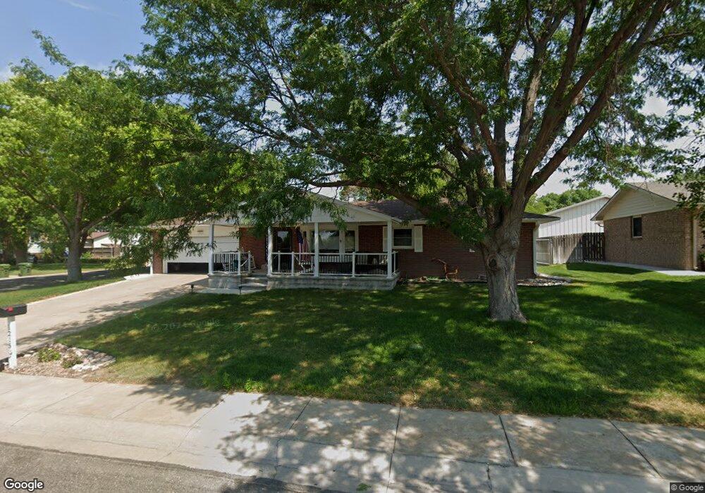
This home is located at 1215 N Brookside Dr, Colby, KS 67701 and is currently estimated at $252,082, approximately $220 per square foot. 1215 N Brookside Dr is a home located in Thomas County with nearby schools including Colby Elementary School, Colby Middle School, and Colby Senior High School.
Ownership History
Date
Name
Owned For
Owner Type
Purchase Details
Closed on
Nov 19, 2021
Bought by
Voss David G
Current Estimated Value
Purchase Details
Closed on
May 1, 2009
Bought by
Heskett Joe L and Heskett Rosalee R
Create a Home Valuation Report for This Property
The Home Valuation Report is an in-depth analysis detailing your home's value as well as a comparison with similar homes in the area
Home Values in the Area
Average Home Value in this Area
Purchase History
| Date | Buyer | Sale Price | Title Company |
|---|---|---|---|
| Voss David G | $225,000 | -- | |
| Heskett Joe L | $144,500 | -- |
Source: Public Records
Tax History
| Year | Tax Paid | Tax Assessment Tax Assessment Total Assessment is a certain percentage of the fair market value that is determined by local assessors to be the total taxable value of land and additions on the property. | Land | Improvement |
|---|---|---|---|---|
| 2025 | $4,635 | $28,478 | $1,910 | $26,568 |
| 2024 | $45 | $27,920 | $1,910 | $26,010 |
| 2023 | $4,217 | $25,852 | $1,708 | $24,144 |
| 2022 | $3,320 | $25,300 | $1,910 | $23,390 |
| 2021 | $3,320 | $21,039 | $1,190 | $19,849 |
| 2020 | $3,320 | $20,930 | $1,190 | $19,740 |
| 2019 | $3,327 | $20,125 | $1,190 | $18,935 |
| 2018 | $3,425 | $20,125 | $1,190 | $18,935 |
| 2017 | $3,466 | $20,125 | $1,190 | $18,935 |
| 2016 | $3,390 | $19,809 | $1,190 | $18,619 |
| 2015 | -- | $19,612 | $1,091 | $18,521 |
| 2014 | -- | $18,894 | $1,091 | $17,803 |
Source: Public Records
Map
Nearby Homes
- 880 N Thompson Ave
- 945 E 9th St
- 175 N Thompson Ave
- 215 W Summit St
- 245 N School Ave
- 775 S Franklin Ave
- 480 W Webster St
- 1111 Court Place
- 1012 Court Terrace
- 1120 Court Place
- 935 W 4th St
- 645 S Lincoln Ave
- 1155 Summer Sun Ave
- 0 Walking Trail Ln
- 1750 Sewell Ave
- 000 County Rd N
- 1442 County Road R
- 000 County Road F
- 000 County Road 17
- 00000
- 1225 N Brookside Dr
- 1210 N Brookside Dr
- 1235 N Brookside Dr
- 750 N Thompson Ave
- 760 N Thompson Ave
- 1175 N Brookside Dr
- 1180 E 8th St
- 1220 Lue Dr
- 1210 E 8th St
- 1255 N Brookside Dr
- 1220 E 8th St
- 1215 Lue Dr
- 1230 E 8th St
- 1125 N Brookside Dr
- 1230 Lue Dr
- 1160 E 8th St
- 1250 N Brookside Dr
- 1250 E 8th St
- 1265 N Brookside Dr
- 1140 E 8th St
Your Personal Tour Guide
Ask me questions while you tour the home.