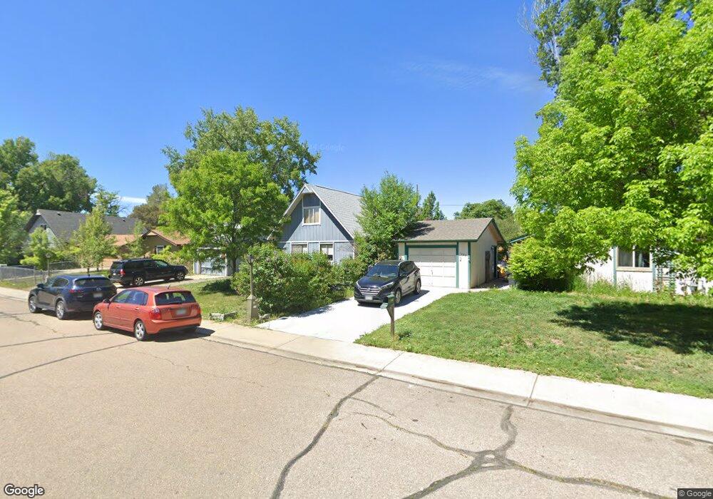
1219 Martin Rd Longmont, CO 80504
Clark Centennial NeighborhoodEstimated Value: $422,511 - $473,000
2
Beds
1
Bath
1,512
Sq Ft
$299/Sq Ft
Est. Value
About This Home
This home is located at 1219 Martin Rd, Longmont, CO 80504 and is currently estimated at $451,628, approximately $298 per square foot. 1219 Martin Rd is a home located in Boulder County with nearby schools including Timberline Pk-8, Skyline High School, and Longmont Christian School.
Ownership History
Date
Name
Owned For
Owner Type
Purchase Details
Closed on
Aug 25, 1993
Bought by
Leaneagh Carol and Buysse Dale W
Current Estimated Value
Purchase Details
Closed on
Dec 28, 1990
Bought by
Leaneagh Carol and Buysse Dale W
Purchase Details
Closed on
May 23, 1990
Bought by
Leaneagh Carol and Buysse Dale W
Purchase Details
Closed on
Dec 1, 1983
Bought by
Leaneagh Carol and Buysse Dale W
Create a Home Valuation Report for This Property
The Home Valuation Report is an in-depth analysis detailing your home's value as well as a comparison with similar homes in the area
Home Values in the Area
Average Home Value in this Area
Purchase History
| Date | Buyer | Sale Price | Title Company |
|---|---|---|---|
| Leaneagh Carol | -- | -- | |
| Leaneagh Carol | -- | -- | |
| Leaneagh Carol | $59,500 | -- | |
| Leaneagh Carol | $72,000 | -- |
Source: Public Records
Tax History Compared to Growth
Tax History
| Year | Tax Paid | Tax Assessment Tax Assessment Total Assessment is a certain percentage of the fair market value that is determined by local assessors to be the total taxable value of land and additions on the property. | Land | Improvement |
|---|---|---|---|---|
| 2025 | $2,130 | $23,157 | $7,538 | $15,619 |
| 2024 | $2,130 | $23,157 | $7,538 | $15,619 |
| 2023 | $2,101 | $22,271 | $8,549 | $17,407 |
| 2022 | $1,920 | $19,404 | $6,338 | $13,066 |
| 2021 | $1,945 | $19,963 | $6,521 | $13,442 |
| 2020 | $1,704 | $17,546 | $5,577 | $11,969 |
| 2019 | $1,678 | $17,546 | $5,577 | $11,969 |
| 2018 | $1,364 | $14,357 | $5,616 | $8,741 |
| 2017 | $1,345 | $15,872 | $6,209 | $9,663 |
| 2016 | $1,217 | $12,736 | $4,935 | $7,801 |
| 2015 | $1,160 | $11,494 | $3,502 | $7,992 |
| 2014 | $1,074 | $11,494 | $3,502 | $7,992 |
Source: Public Records
Map
Nearby Homes
- 1211 Meadow St
- 1226 Atwood St
- 10 Juneau Place
- 147 Dawson Place
- 1147 Emery St
- 1430 Lashley St
- 845 Martin St
- 117 Valentine Ln
- 1514 Collyer St
- 342 9th Ave
- 936 Kimbark St Unit 4
- 1310 Hilltop Dr
- 50 Forsyth Dr
- 836 Emery St
- 823 Collyer St
- 830 Emery St
- 1455 Hilltop Dr
- 727 Baker St
- 1534 Mount Evans Dr
- 820 Kimbark St Unit D
- 1225 Martin Rd
- 1213 Martin Rd
- 1231 Martin Rd
- 1207 Martin Rd
- 1237 Martin Rd
- 1224 Martin Rd
- 1224 Meadow St
- 1220 Meadow St
- 1228 Meadow St
- 1216 Meadow St
- 1201 Martin Rd
- 1232 Meadow St
- 1212 Meadow St
- 1232 Martin Rd
- 1236 Meadow St
- 1208 Meadow St
- 1243 Martin Rd
- 26 Powder Horn Place
- 1240 Meadow St
- 1238 Martin Rd