
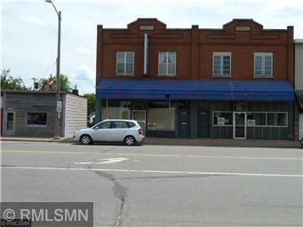
122 & 124 W Main St Crosby, MN 56441
Estimated Value: $270,000
--
Bed
--
Bath
4,900
Sq Ft
$55/Sq Ft
Est. Value
Highlights
- Business Center
- Hot Water Heating System
- 3-minute walk to Crosby Memorial Park
- 2 Car Detached Garage
- Wood Siding
About This Home
As of October 2018(122 W Main) small building needs to be demolished or moved and could be used for parking. (124 W Main) has been gutted and ready for your remodel.
Property Details
Property Type
- Other
Est. Annual Taxes
- $1,727
Year Built
- Built in 1911
Lot Details
- 6,098 Sq Ft Lot
- Lot Dimensions are 50 x 125
Parking
- 2 Car Detached Garage
Home Design
- Wood Siding
- Stone Siding
Utilities
- Hot Water Heating System
Community Details
- 3 Units
- Business Center
Listing and Financial Details
- Assessor Parcel Number 111110050280889
Ownership History
Date
Name
Owned For
Owner Type
Purchase Details
Closed on
Oct 1, 2003
Sold by
Allguire Robert M
Bought by
Stark Gareth Albin
Total Days on Market
0
Current Estimated Value
Create a Home Valuation Report for This Property
The Home Valuation Report is an in-depth analysis detailing your home's value as well as a comparison with similar homes in the area
Similar Homes in Crosby, MN
Home Values in the Area
Average Home Value in this Area
Purchase History
| Date | Buyer | Sale Price | Title Company |
|---|---|---|---|
| Stark Gareth Albin | $60,000 | -- |
Source: Public Records
Property History
| Date | Event | Price | Change | Sq Ft Price |
|---|---|---|---|---|
| 10/18/2018 10/18/18 | Sold | $97,000 | 0.0% | $20 / Sq Ft |
| 08/27/2018 08/27/18 | Pending | -- | -- | -- |
| 08/27/2018 08/27/18 | For Sale | $97,000 | -- | $20 / Sq Ft |
Source: NorthstarMLS
Tax History Compared to Growth
Tax History
| Year | Tax Paid | Tax Assessment Tax Assessment Total Assessment is a certain percentage of the fair market value that is determined by local assessors to be the total taxable value of land and additions on the property. | Land | Improvement |
|---|---|---|---|---|
| 2024 | $6,752 | $347,900 | $55,900 | $292,000 |
| 2023 | $4,428 | $239,800 | $54,400 | $185,400 |
| 2022 | $2,482 | $144,300 | $32,200 | $112,100 |
| 2021 | $1,892 | $118,700 | $31,300 | $87,400 |
| 2020 | $1,812 | $94,500 | $31,300 | $63,200 |
| 2019 | $1,800 | $78,600 | $27,400 | $51,200 |
| 2018 | $1,742 | $82,000 | $22,400 | $59,600 |
| 2017 | $2,042 | $80,500 | $19,400 | $61,100 |
| 2016 | $2,906 | $106,600 | $14,400 | $92,200 |
| 2015 | $3,024 | $108,400 | $14,400 | $94,000 |
| 2014 | $1,528 | $108,900 | $12,900 | $96,000 |
Source: Public Records
Map
Source: NorthstarMLS
MLS Number: NST4997604
APN: 111110050280889
Disclaimer: Certain information contained herein is derived from information provided by parties other than Homes.com. All information provided is deemed reliable, but is not guaranteed to be accurate and should be independently verified.
![]() Based on information submitted to the MLS GRID. All data is obtained from various sources and may not have been verified by broker or MLS GRID. Supplied Open House Information is subject to change without notice. All information should be independently reviewed and verified for accuracy. Properties may or may not be listed by the office/agent presenting the information. Some IDX listings have been excluded from this website.
Based on information submitted to the MLS GRID. All data is obtained from various sources and may not have been verified by broker or MLS GRID. Supplied Open House Information is subject to change without notice. All information should be independently reviewed and verified for accuracy. Properties may or may not be listed by the office/agent presenting the information. Some IDX listings have been excluded from this website.
The Digital Millennium Copyright Act of 1998, 17 U.S.C. § 512 (the “DMCA”) provides recourse for copyright owners who believe that material appearing on the Internet infringes their rights under U.S. copyright law. If you believe in good faith that any content or material made available in connection with our website or services infringes your copyright, you (or your agent) may send us a notice requesting that the content or material be removed, or access to it blocked.
Notices must be sent in writing by email to DMCAnotice@MLSGrid.com.
The DMCA requires that your notice of alleged copyright infringement include the following information:
(1) description of the copyrighted work that is the subject of claimed infringement;
(2) description of the alleged infringing content and information sufficient to permit us to locate the content;
(3) contact information for you, including your address, telephone number and email address;
(4) a statement by you that you have a good faith belief that the content in the manner complained of is not authorized by the copyright owner, or its agent, or by the operation of any law;
(5) a statement by you, signed under penalty of perjury, that the information in the notification is accurate and that you have the authority to enforce the copyrights that are claimed to be infringed; and
(6) a physical or electronic signature of the copyright owner or a person authorized to act on the copyright owner’s behalf. Failure to include all of the above information may result in the delay of the processing of your complaint.
Nearby Homes
- 206 1st St NW
- 214 3rd St NW
- 209 4th St NW
- 127 2nd St NE
- 16 Deblock Ln
- 509 Superior Ave
- 202 6th Ave SW
- 508 Superior Ave
- 611 3rd St SW
- 132 6th St NE
- 205 6th St NE
- 622 Erie Ave
- 20426 Evans Rd
- 213 5th St
- 513 5th Ave
- 22840 Thompson Point Rd
- 23726 Fox Run Ln
- Parcel E County Road 12
- Parcel F County Road 12
- 21965 Shady Walk Unit 201