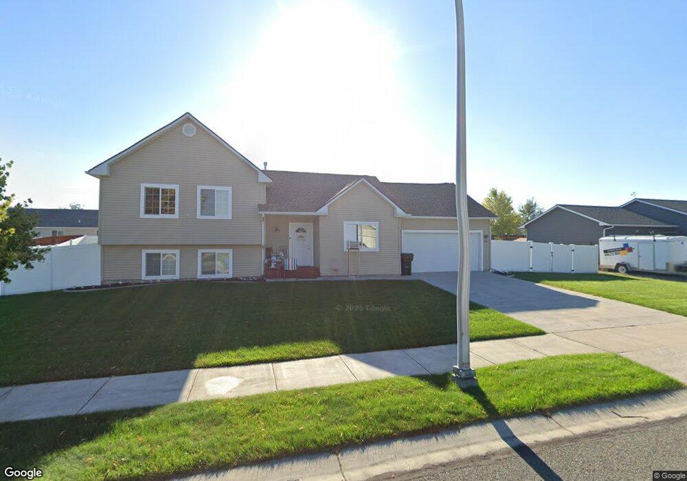
122 Fly Way Kalispell, MT 59901
Estimated Value: $504,000 - $585,000
3
Beds
2
Baths
1,640
Sq Ft
$323/Sq Ft
Est. Value
About This Home
This home is located at 122 Fly Way, Kalispell, MT 59901 and is currently estimated at $530,432, approximately $323 per square foot. 122 Fly Way is a home located in Flathead County with nearby schools including West Valley Elementary School, West Valley Middle School, and Glacier High School.
Ownership History
Date
Name
Owned For
Owner Type
Purchase Details
Closed on
Jul 30, 2010
Sold by
Heck Roger Arthur and Marital Trust Of The Heck Fami
Bought by
Waggener Jody R
Current Estimated Value
Home Financials for this Owner
Home Financials are based on the most recent Mortgage that was taken out on this home.
Original Mortgage
$178,600
Outstanding Balance
$141,318
Interest Rate
4.71%
Mortgage Type
Purchase Money Mortgage
Estimated Equity
$389,114
Purchase Details
Closed on
May 17, 2006
Sold by
Ron Terry Construction Inc
Bought by
Heck Roger Arthur and Marital Trust Of The Heck Fami
Purchase Details
Closed on
Jan 27, 2006
Home Financials for this Owner
Home Financials are based on the most recent Mortgage that was taken out on this home.
Original Mortgage
$150,870
Interest Rate
6.16%
Mortgage Type
Purchase Money Mortgage
Create a Home Valuation Report for This Property
The Home Valuation Report is an in-depth analysis detailing your home's value as well as a comparison with similar homes in the area
Purchase History
| Date | Buyer | Sale Price | Title Company |
|---|---|---|---|
| Waggener Jody R | -- | Insured Titles | |
| Heck Roger Arthur | -- | Sterling Title Services Inc | |
| -- | -- | -- |
Source: Public Records
Mortgage History
| Date | Status | Borrower | Loan Amount |
|---|---|---|---|
| Open | Waggener Jody R | $178,600 | |
| Previous Owner | -- | $150,870 |
Source: Public Records
Tax History
| Year | Tax Paid | Tax Assessment Tax Assessment Total Assessment is a certain percentage of the fair market value that is determined by local assessors to be the total taxable value of land and additions on the property. | Land | Improvement |
|---|---|---|---|---|
| 2025 | $2,453 | $496,500 | $0 | $0 |
| 2024 | $2,955 | $410,300 | $0 | $0 |
| 2023 | $3,343 | $410,300 | $0 | $0 |
| 2022 | $3,183 | $294,400 | $0 | $0 |
| 2021 | $3,159 | $294,400 | $0 | $0 |
| 2020 | $3,005 | $249,100 | $0 | $0 |
| 2019 | $2,968 | $249,100 | $0 | $0 |
| 2018 | $2,752 | $214,600 | $0 | $0 |
| 2017 | $2,749 | $214,600 | $0 | $0 |
| 2016 | $2,430 | $192,700 | $0 | $0 |
| 2015 | $2,450 | $192,700 | $0 | $0 |
| 2014 | $2,390 | $111,671 | $0 | $0 |
Source: Public Records
Map
Nearby Homes
- 38 Vanderbilt Dr
- 90 Empire Loop
- 63 Empire Loop
- 17 Empire Loop
- 174 Empire Loop
- 140 Barron Way
- 408 Needlegrass Ln
- 417 Needlegrass Ln
- 287 Kara Dr
- 119 Barron Way
- 249 Three Mile Dr
- 240 Kara Dr
- 433 Needlegrass Ln
- 108 Hearst Dr
- 224 Kara Dr
- 210 Kara Dr
- 412 Needlegrass Ln
- 424 Needlegrass Ln
- 1280 Quarter Horse Ln
- 420 Needlegrass Ln
Your Personal Tour Guide
Ask me questions while you tour the home.