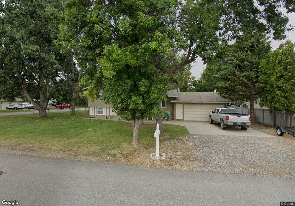
122 Peters St Billings, MT 59101
Lockwood NeighborhoodEstimated Value: $338,000 - $422,000
4
Beds
2
Baths
1,072
Sq Ft
$346/Sq Ft
Est. Value
About This Home
This home is located at 122 Peters St, Billings, MT 59101 and is currently estimated at $371,134, approximately $346 per square foot. 122 Peters St is a home located in Yellowstone County with nearby schools including Lockwood Primary School, Lockwood Intermediate School, and Lockwood Middle School.
Ownership History
Date
Name
Owned For
Owner Type
Purchase Details
Closed on
Jul 13, 2021
Sold by
Tresch Keith E and Tuss Morgan E
Bought by
Peters Street Limited Liability Company
Current Estimated Value
Purchase Details
Closed on
Apr 13, 2021
Sold by
Tresch Keith E
Bought by
Tresch Keith E and Tuss Morgan E
Purchase Details
Closed on
May 7, 2020
Sold by
Peters Street Limited Liability Company
Bought by
Tresch Keith E
Purchase Details
Closed on
Jun 3, 2013
Sold by
Tresch Keith E
Bought by
Peters Street Limited Liability Company
Purchase Details
Closed on
Jan 20, 2011
Sold by
Tresch Keith E and Tresch Jennifer
Bought by
Tresch Keith E
Home Financials for this Owner
Home Financials are based on the most recent Mortgage that was taken out on this home.
Original Mortgage
$188,467
Interest Rate
4.9%
Mortgage Type
VA
Create a Home Valuation Report for This Property
The Home Valuation Report is an in-depth analysis detailing your home's value as well as a comparison with similar homes in the area
Home Values in the Area
Average Home Value in this Area
Purchase History
| Date | Buyer | Sale Price | Title Company |
|---|---|---|---|
| Peters Street Limited Liability Company | -- | None Available | |
| Tresch Keith E | -- | None Listed On Document | |
| Tresch Keith E | -- | None Available | |
| Peters Street Limited Liability Company | -- | None Available | |
| Tresch Keith E | -- | None Available |
Source: Public Records
Mortgage History
| Date | Status | Borrower | Loan Amount |
|---|---|---|---|
| Previous Owner | Tresch Keith E | $188,467 |
Source: Public Records
Tax History Compared to Growth
Tax History
| Year | Tax Paid | Tax Assessment Tax Assessment Total Assessment is a certain percentage of the fair market value that is determined by local assessors to be the total taxable value of land and additions on the property. | Land | Improvement |
|---|---|---|---|---|
| 2025 | $3,388 | $316,800 | $52,625 | $264,175 |
| 2024 | $3,388 | $275,900 | $44,939 | $230,961 |
| 2023 | $3,361 | $275,900 | $44,939 | $230,961 |
| 2022 | $3,247 | $229,100 | $0 | $0 |
| 2021 | $3,192 | $229,100 | $0 | $0 |
| 2020 | $3,014 | $214,200 | $0 | $0 |
| 2019 | $3,057 | $214,200 | $0 | $0 |
| 2018 | $2,927 | $187,900 | $0 | $0 |
| 2017 | $2,489 | $187,900 | $0 | $0 |
| 2016 | $2,364 | $181,000 | $0 | $0 |
| 2015 | $1,912 | $181,000 | $0 | $0 |
| 2014 | $1,790 | $88,987 | $0 | $0 |
Source: Public Records
Map
Nearby Homes
- 1803 U S Highway 87 E Unit 4
- 5 Piccolo Ln
- 2120 Hillner Ln
- 5326 Old Hardin Rd
- TBD 1-4 Old Hardin Rd
- 5236 Old Hardin Rd
- 119 Nightingale Dr
- 149 Nightingale Dr
- 21 Hemlock Dr Unit 14
- 2224 U S Highway 87 E
- 2224 U S Highway 87 E Unit 90
- 2224 U S Highway 87 E Unit 28
- 2224 Us Highway 87 E Unit 57
- 242 Hemlock Dr
- 2528 Sterling St
- 2710 Silverton St
- 855 Joyce Cir
- 3121 & 3123 Prairie Dr
- 504 Elephant Butte Ln
- 38 Danube St
- 114 Peters St
- 144 Rock Hill Dr
- 106 Peters St
- 121 Rock Hill Dr
- 136 Rock Hill Dr
- 140 Peters St
- 42 Peters St
- 130 Rock Hill Dr
- 107 Rock Hill Dr
- 124 Rock Hill Dr
- 148 Peters St
- 118 Rock Hill Dr
- 34 Peters St
- 110 Rock Hill Dr
- 43 Rock Hill Dr
- 104 Rock Hill Dr
- 35 Rock Hill Dr
- 156 Peters St
- 48 Rock Hill Dr
- 26 Peters St