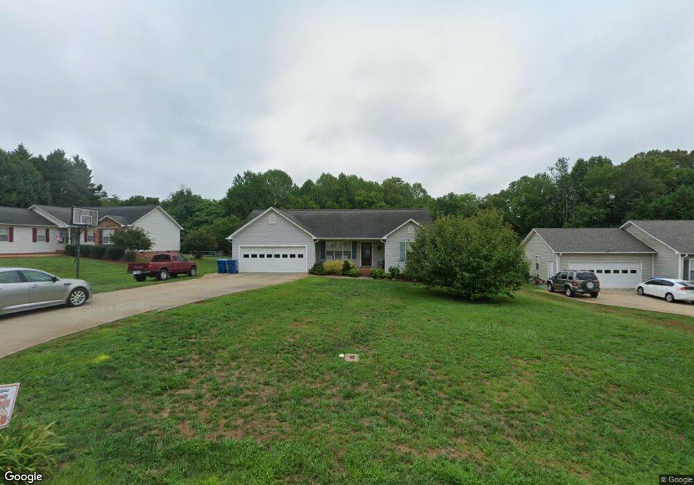
122 Polaris Dr Mocksville, NC 27028
Estimated Value: $250,000 - $312,000
3
Beds
2
Baths
1,476
Sq Ft
$181/Sq Ft
Est. Value
About This Home
This home is located at 122 Polaris Dr, Mocksville, NC 27028 and is currently estimated at $267,605, approximately $181 per square foot. 122 Polaris Dr is a home located in Davie County with nearby schools including Mocksville Elementary School, South Davie Middle, and Davie County High School.
Ownership History
Date
Name
Owned For
Owner Type
Purchase Details
Closed on
Nov 1, 2004
Current Estimated Value
Purchase Details
Closed on
Dec 1, 2000
Purchase Details
Closed on
Jun 1, 2000
Purchase Details
Closed on
Oct 1, 1999
Create a Home Valuation Report for This Property
The Home Valuation Report is an in-depth analysis detailing your home's value as well as a comparison with similar homes in the area
Home Values in the Area
Average Home Value in this Area
Purchase History
| Date | Buyer | Sale Price | Title Company |
|---|---|---|---|
| -- | $127,000 | -- | |
| -- | $127,000 | -- | |
| -- | $119,000 | -- | |
| -- | $12,000 | -- |
Source: Public Records
Tax History Compared to Growth
Tax History
| Year | Tax Paid | Tax Assessment Tax Assessment Total Assessment is a certain percentage of the fair market value that is determined by local assessors to be the total taxable value of land and additions on the property. | Land | Improvement |
|---|---|---|---|---|
| 2025 | $2,322 | $237,310 | $50,000 | $187,310 |
| 2024 | $1,716 | $161,430 | $16,500 | $144,930 |
| 2023 | $1,716 | $161,430 | $16,500 | $144,930 |
| 2022 | $1,716 | $161,430 | $16,500 | $144,930 |
| 2021 | $1,716 | $161,430 | $16,500 | $144,930 |
| 2020 | $1,442 | $135,020 | $16,500 | $118,520 |
| 2019 | $1,442 | $135,020 | $16,500 | $118,520 |
| 2018 | $1,442 | $135,020 | $16,500 | $118,520 |
| 2017 | $1,429 | $135,020 | $0 | $0 |
| 2016 | $1,472 | $139,140 | $0 | $0 |
| 2015 | $1,472 | $139,140 | $0 | $0 |
| 2014 | $1,322 | $139,140 | $0 | $0 |
| 2013 | -- | $139,140 | $0 | $0 |
Source: Public Records
Map
Nearby Homes
- 408 E Lake Dr
- 186 Crestview Dr
- 701 E Lexington Rd
- 135 Winding Creek Rd
- 158 John Crotts Rd
- 1 lot E Depot St
- 408 Pine St
- 351 Honeysuckle St
- 792 S Main St
- 191 Big Laurel Dr
- 193 Big Laurel Dr
- 412 S Main St
- 161 Big Laurel Dr
- 147 Charleston Meadow Loop
- 147 Ariel Ct
- 194 Big Laurel Dr
- 192 Big Laurel Dr
- 190 Big Laurel Dr
- KYLE Plan at Hudson Glen
- BELHAVEN Plan at Hudson Glen
- 130 Polaris Dr
- 112 Polaris Dr
- 100 Polaris Dr
- 138 Polaris Dr
- 104 Polaris Dr
- 101 Polaris Dr
- 532 E Lake Dr
- 148 Polaris Dr
- 121 Polaris Dr
- 129 Polaris Dr
- 137 Polaris Dr
- 156 Polaris Dr
- 109 Carriage Cove Cir
- 147 Polaris Dr
- 173 Sunnydell Ln
- 113 Carriage Cove Cir Unit 2
- 535 E Lake Dr
- 166 Polaris Dr
- 157 Polaris Dr
- 117 Carriage Cove Cir