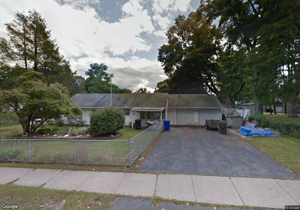
1220 Allen St Springfield, MA 01118
East Forest Park NeighborhoodEstimated Value: $301,000 - $320,000
3
Beds
1
Bath
1,392
Sq Ft
$222/Sq Ft
Est. Value
About This Home
This home is located at 1220 Allen St, Springfield, MA 01118 and is currently estimated at $309,018, approximately $221 per square foot. 1220 Allen St is a home located in Hampden County with nearby schools including Frederick Harris Elementary School, M Marcus Kiley Middle, and Springfield High School of Science and Technology.
Ownership History
Date
Name
Owned For
Owner Type
Purchase Details
Closed on
Jan 30, 1995
Sold by
Petig Joan M
Bought by
Cardinal James K F and Cardinal Nancy L F
Current Estimated Value
Home Financials for this Owner
Home Financials are based on the most recent Mortgage that was taken out on this home.
Original Mortgage
$83,436
Interest Rate
9.24%
Mortgage Type
Purchase Money Mortgage
Purchase Details
Closed on
Apr 29, 1988
Sold by
Jerry Mark G
Bought by
Petig Joan M
Home Financials for this Owner
Home Financials are based on the most recent Mortgage that was taken out on this home.
Original Mortgage
$46,000
Interest Rate
9.86%
Mortgage Type
Purchase Money Mortgage
Create a Home Valuation Report for This Property
The Home Valuation Report is an in-depth analysis detailing your home's value as well as a comparison with similar homes in the area
Home Values in the Area
Average Home Value in this Area
Purchase History
| Date | Buyer | Sale Price | Title Company |
|---|---|---|---|
| Cardinal James K F | $83,500 | -- | |
| Petig Joan M | $84,000 | -- |
Source: Public Records
Mortgage History
| Date | Status | Borrower | Loan Amount |
|---|---|---|---|
| Open | Petig Joan M | $86,400 | |
| Closed | Petig Joan M | $83,436 | |
| Previous Owner | Petig Joan M | $46,000 |
Source: Public Records
Tax History Compared to Growth
Tax History
| Year | Tax Paid | Tax Assessment Tax Assessment Total Assessment is a certain percentage of the fair market value that is determined by local assessors to be the total taxable value of land and additions on the property. | Land | Improvement |
|---|---|---|---|---|
| 2025 | $3,710 | $236,600 | $59,500 | $177,100 |
| 2024 | $3,581 | $223,000 | $59,500 | $163,500 |
| 2023 | $3,315 | $194,400 | $56,700 | $137,700 |
| 2022 | $3,086 | $164,000 | $56,700 | $107,300 |
| 2021 | $2,858 | $151,200 | $51,500 | $99,700 |
| 2020 | $2,711 | $138,800 | $51,500 | $87,300 |
| 2019 | $2,755 | $140,000 | $51,500 | $88,500 |
| 2018 | $2,590 | $131,600 | $51,500 | $80,100 |
| 2017 | $2,570 | $130,700 | $51,500 | $79,200 |
| 2016 | $2,458 | $125,000 | $51,500 | $73,500 |
| 2015 | $2,354 | $119,700 | $51,500 | $68,200 |
Source: Public Records
Map
Nearby Homes
- 54 Shady Brook Ln
- 55 Allen St
- 43 Sunridge Dr
- 196 Sawmill Rd
- 17 Pebble Mill Rd
- 5 Manor Ct Unit 5
- 19 Manor Ct Unit 19
- 86 Talmadge Dr
- 125 Manor Ct Unit 125
- 101 Regal St
- 82 Louis Rd
- 290 Newton Rd
- 206 Treetop Ave
- 27 Regal St
- 392 Gifford St
- 157 Canterbury Rd
- 99 W Crystal Brook Dr
- 95 Benz St
- 77 W Allen Ridge Rd
- 767 S Branch Pkwy
- 16 Shady Brook Ln
- 1206 Allen St
- 13 Corcoran Blvd
- 5 Shady Brook Ln
- 26 Shady Brook Ln
- 23 Corcoran Blvd
- 15 Shady Brook Ln
- 1227 Allen St
- 1225 Allen St
- 1235 Allen St
- 1201 Allen St
- 25 Shady Brook Ln
- 1241 Allen St
- 6 Corcoran Blvd
- 36 Shady Brook Ln
- 31 Corcoran Blvd
- 18 Corcoran Blvd
- 1195 Allen St
- 33 Shady Brook Ln
- 1551 Sumner Ave