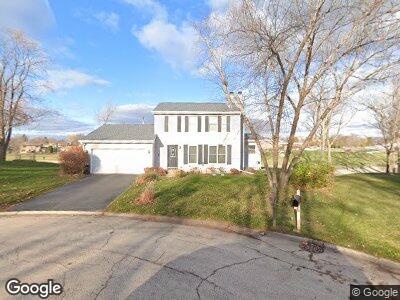
1220 Fairmont Ct Algonquin, IL 60102
High Hill Farms NeighborhoodEstimated Value: $271,110 - $349,000
3
Beds
2
Baths
1,345
Sq Ft
$240/Sq Ft
Est. Value
About This Home
This home is located at 1220 Fairmont Ct, Algonquin, IL 60102 and is currently estimated at $322,528, approximately $239 per square foot. 1220 Fairmont Ct is a home located in McHenry County with nearby schools including Westfield Community School, Kenneth E Neubert Elementary School, and Harry D Jacobs High School.
Ownership History
Date
Name
Owned For
Owner Type
Purchase Details
Closed on
Oct 12, 1993
Sold by
Mount Anson A and Mount Carol M
Bought by
Lerner Michael H and Lerner Eleanor R
Current Estimated Value
Home Financials for this Owner
Home Financials are based on the most recent Mortgage that was taken out on this home.
Original Mortgage
$90,000
Interest Rate
7.02%
Create a Home Valuation Report for This Property
The Home Valuation Report is an in-depth analysis detailing your home's value as well as a comparison with similar homes in the area
Home Values in the Area
Average Home Value in this Area
Purchase History
| Date | Buyer | Sale Price | Title Company |
|---|---|---|---|
| Lerner Michael H | $126,000 | Northwestern Illinois Title |
Source: Public Records
Mortgage History
| Date | Status | Borrower | Loan Amount |
|---|---|---|---|
| Open | Lerner Michael H | $115,000 | |
| Closed | Lerner Michael H | $80,900 | |
| Closed | Lerner Michael H | $70,000 | |
| Closed | Lerner Michael H | $90,000 |
Source: Public Records
Tax History Compared to Growth
Tax History
| Year | Tax Paid | Tax Assessment Tax Assessment Total Assessment is a certain percentage of the fair market value that is determined by local assessors to be the total taxable value of land and additions on the property. | Land | Improvement |
|---|---|---|---|---|
| 2023 | $5,219 | $84,396 | $21,993 | $62,403 |
| 2022 | $5,775 | $78,339 | $21,044 | $57,295 |
| 2021 | $5,500 | $72,982 | $19,605 | $53,377 |
| 2020 | $5,334 | $70,398 | $18,911 | $51,487 |
| 2019 | $5,177 | $67,379 | $18,100 | $49,279 |
| 2018 | $4,884 | $62,244 | $16,721 | $45,523 |
| 2017 | $4,744 | $58,638 | $15,752 | $42,886 |
| 2016 | $4,627 | $54,997 | $14,774 | $40,223 |
| 2013 | -- | $51,823 | $13,783 | $38,040 |
Source: Public Records
Map
Nearby Homes
- 355 Crestwood Ct
- 313 Bayberry Dr
- 731 Roaring Brook Ln
- 1370 Grandview Ct
- 705 Harper Dr
- 1 N Hubbard St
- 543 Blackhawk Dr
- 541 Blackhawk Dr
- 3 Regal Ct
- Lots 10 & 11 Ramble Rd
- 305 Buckingham Dr
- 930 Pleasant View Dr
- 985 Viewpoint Dr
- 1095 Saint Andrews Ct Unit 292
- 900 Windstone Ct
- 987 Mesa Dr
- 4 Hawthorne Rd
- 32 Jayne St
- 1108 Viewpoint Dr
- 14 Wander Way
- 1220 Fairmont Ct
- 1215 Fairmont Ct
- 1240 Fairmont Ct
- 1210 Harnish Dr
- 1225 Fairmont Ct
- 1235 Fairmont Ct
- 1245 Fairmont Ct
- 412 E Parkview Terrace
- 422 E Parkview Terrace
- 432 E Parkview Terrace
- 1200 Harnish Dr
- 501 Terrace Dr
- 402 E Parkview Terrace
- 502 Terrace Dr
- 442 E Parkview Terrace
- 500 Eagle Ridge Ln
- 425 Amber Wood Ct Unit 4
- 1310 Cherry Wood Ct
- 435 Amber Wood Ct
- 511 Terrace Dr