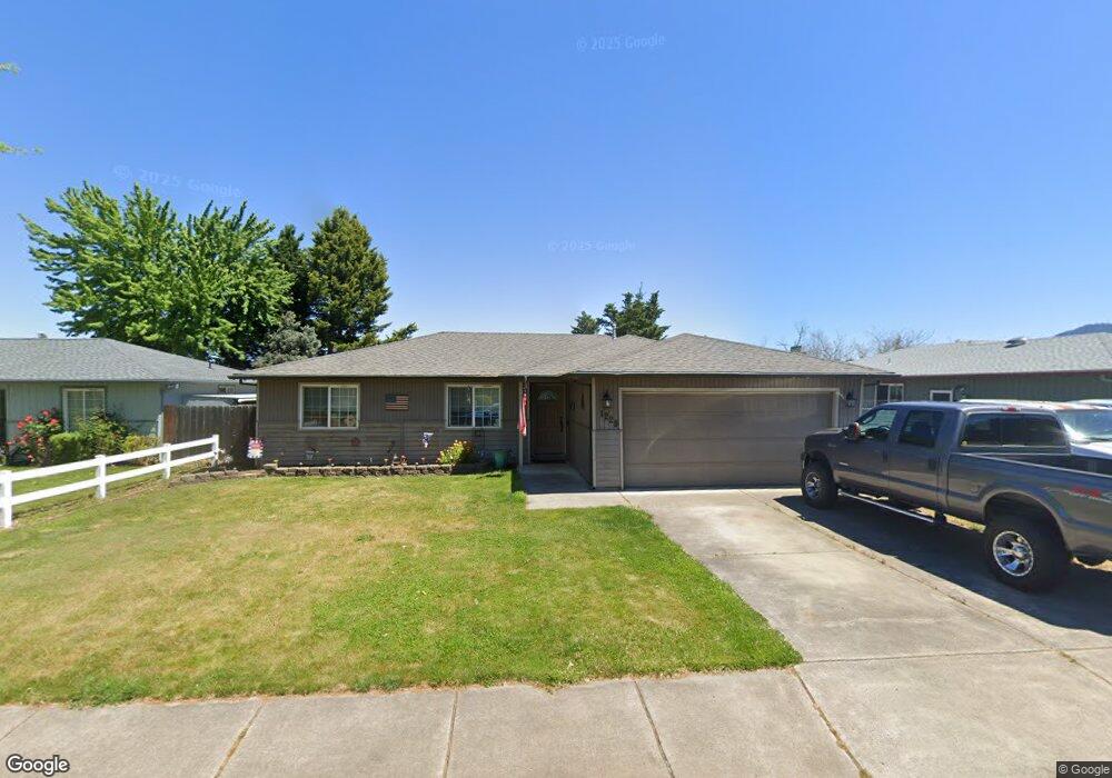
1229 Far West Ave Central Point, OR 97502
Estimated Value: $328,000 - $352,464
3
Beds
2
Baths
1,148
Sq Ft
$300/Sq Ft
Est. Value
About This Home
This home is located at 1229 Far West Ave, Central Point, OR 97502 and is currently estimated at $344,116, approximately $299 per square foot. 1229 Far West Ave is a home located in Jackson County with nearby schools including Howard Elementary School, McLoughlin Middle School, and North Medford High School.
Ownership History
Date
Name
Owned For
Owner Type
Purchase Details
Closed on
Mar 17, 2021
Sold by
Mauck Derek E
Bought by
Mauck Derek Edward and Oconnor Monica Jeanette
Current Estimated Value
Home Financials for this Owner
Home Financials are based on the most recent Mortgage that was taken out on this home.
Original Mortgage
$131,000
Outstanding Balance
$117,432
Interest Rate
2.7%
Mortgage Type
New Conventional
Estimated Equity
$226,684
Purchase Details
Closed on
Apr 1, 2005
Sold by
Cumiford R Scott and Cumiford Julie A
Bought by
Mauck Derek E
Home Financials for this Owner
Home Financials are based on the most recent Mortgage that was taken out on this home.
Original Mortgage
$183,000
Interest Rate
5.6%
Mortgage Type
Purchase Money Mortgage
Create a Home Valuation Report for This Property
The Home Valuation Report is an in-depth analysis detailing your home's value as well as a comparison with similar homes in the area
Home Values in the Area
Average Home Value in this Area
Purchase History
| Date | Buyer | Sale Price | Title Company |
|---|---|---|---|
| Mauck Derek Edward | -- | Lawyers Title Of Oregon Llc | |
| Mauck Derek E | $183,000 | Amerititle |
Source: Public Records
Mortgage History
| Date | Status | Borrower | Loan Amount |
|---|---|---|---|
| Open | Mauck Derek Edward | $131,000 | |
| Closed | Mauck Derek E | $183,000 |
Source: Public Records
Tax History Compared to Growth
Tax History
| Year | Tax Paid | Tax Assessment Tax Assessment Total Assessment is a certain percentage of the fair market value that is determined by local assessors to be the total taxable value of land and additions on the property. | Land | Improvement |
|---|---|---|---|---|
| 2025 | $3,175 | $189,760 | $57,430 | $132,330 |
| 2024 | $3,175 | $184,240 | $55,760 | $128,480 |
| 2023 | $3,078 | $178,880 | $54,130 | $124,750 |
| 2022 | $3,001 | $178,880 | $54,130 | $124,750 |
| 2021 | $2,922 | $173,670 | $52,560 | $121,110 |
| 2020 | $2,849 | $168,620 | $51,030 | $117,590 |
| 2019 | $2,779 | $158,950 | $48,110 | $110,840 |
| 2018 | $2,706 | $154,330 | $46,700 | $107,630 |
| 2017 | $2,774 | $154,330 | $46,700 | $107,630 |
| 2016 | $2,596 | $145,480 | $44,010 | $101,470 |
| 2015 | $2,496 | $145,480 | $44,010 | $101,470 |
| 2014 | $2,450 | $137,140 | $41,480 | $95,660 |
Source: Public Records
Map
Nearby Homes
- 3119 Merriman Rd
- 811 O'Hare Pkwy
- 1025 Fairfield Ave
- 1017 Fairfield Ave
- 2772 Merriman Rd
- 529 Black Bear Dr
- 1060 Hopkins Rd
- 2825 Howard Ave
- 921 Pittview Ave
- 460 Federal Way
- 881 Westrop Dr
- 191 Mellecker Way
- 659 Herman Ave
- 199 Mellecker Way
- 450 Midway Rd Unit 16
- 450 Midway Rd Unit 5
- 246 Reanna Way
- 928 Brandi Way
- 745 Herman Ave
- 2621 Merriman Rd Unit 3000
- 1235 Far West Ave
- 1225 Far West Ave
- 1223 Far Ave W
- 1239 Far West Ave
- 1223 Far West Ave
- 1226 Far Ave W
- 1230 Far West Ave
- 1226 Far West Ave
- 1243 Far West Ave
- 1221 Far Ave W
- 1238 Far West Ave
- 1243 Far Ave W
- 1221 Far West Ave
- 1220 Far West Ave
- 1242 Far West Ave
- 1217 Far Ave W
- 1251 Far West Ave
- 1217 Far West Ave Unit 3
- 1251 Far Ave W
- 1246 Far West Ave