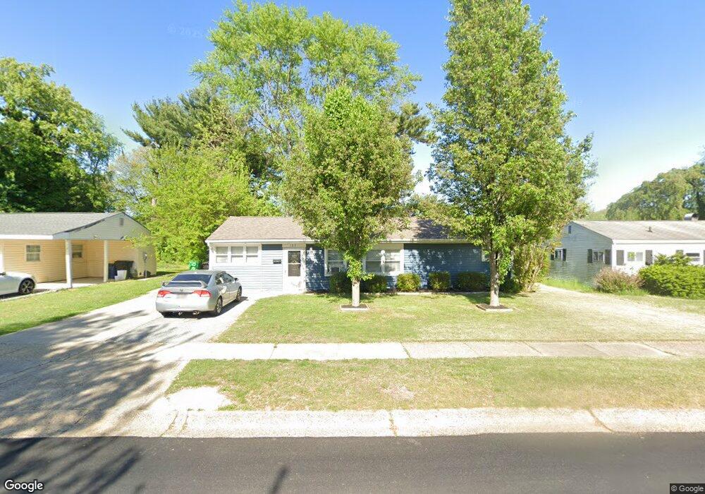
123 Woodbrook Rd Dover, DE 19901
Kent Acres NeighborhoodEstimated Value: $190,000 - $265,000
4
Beds
1
Bath
1,350
Sq Ft
$177/Sq Ft
Est. Value
About This Home
This home is located at 123 Woodbrook Rd, Dover, DE 19901 and is currently estimated at $238,322, approximately $176 per square foot. 123 Woodbrook Rd is a home located in Kent County with nearby schools including W. Reily Brown Elementary School, Fred Fifer Middle School, and Caesar Rodney High School.
Ownership History
Date
Name
Owned For
Owner Type
Purchase Details
Closed on
Oct 8, 2025
Sold by
Rangel J Carmen
Bought by
Rangel-Cardoso David and Torres Maria S
Current Estimated Value
Purchase Details
Closed on
Aug 14, 2006
Sold by
Clyburn Billie J and Clyburn Donna L
Bought by
Rangel J Carmen
Home Financials for this Owner
Home Financials are based on the most recent Mortgage that was taken out on this home.
Original Mortgage
$128,881
Interest Rate
6.83%
Mortgage Type
FHA
Create a Home Valuation Report for This Property
The Home Valuation Report is an in-depth analysis detailing your home's value as well as a comparison with similar homes in the area
Home Values in the Area
Average Home Value in this Area
Purchase History
| Date | Buyer | Sale Price | Title Company |
|---|---|---|---|
| Rangel-Cardoso David | -- | None Listed On Document | |
| Rangel J Carmen | $1,948 | None Available |
Source: Public Records
Mortgage History
| Date | Status | Borrower | Loan Amount |
|---|---|---|---|
| Previous Owner | Rangel J Carmen | $128,881 |
Source: Public Records
Tax History
| Year | Tax Paid | Tax Assessment Tax Assessment Total Assessment is a certain percentage of the fair market value that is determined by local assessors to be the total taxable value of land and additions on the property. | Land | Improvement |
|---|---|---|---|---|
| 2025 | $1,214 | $200,200 | $67,800 | $132,400 |
| 2024 | $1,218 | $200,200 | $67,800 | $132,400 |
| 2023 | $995 | $22,700 | $9,700 | $13,000 |
| 2022 | $946 | $22,700 | $9,700 | $13,000 |
| 2021 | $931 | $22,700 | $9,700 | $13,000 |
| 2020 | $906 | $22,700 | $9,700 | $13,000 |
| 2019 | $885 | $22,700 | $9,700 | $13,000 |
| 2018 | $867 | $22,700 | $9,700 | $13,000 |
| 2017 | $853 | $22,700 | $0 | $0 |
| 2016 | $786 | $22,700 | $0 | $0 |
| 2015 | $707 | $22,700 | $0 | $0 |
| 2014 | $701 | $22,700 | $0 | $0 |
Source: Public Records
Map
Nearby Homes
- 7 Steele Rd
- 89 Cooper Rd
- 207 Gunning Bedford Dr
- 100 S Shore Dr
- 89 S Shore Dr
- 135 N Fairfield Dr
- 248 Webbs Ln
- 311 Mimosa Ave
- 48 John Collins Cir
- 97 Glenda Rd
- 386 David Hall Rd
- 361 Kesselring Ave
- 1679 S State St Unit A55
- 137 McBry Dr
- 200 Beechwood Ave Unit 30
- 949 Westview Terrace
- 127 Roosevelt Ave
- 142 Carter Ln
- 288 Cambridge Rd
- 6 Crossley Dr
Your Personal Tour Guide
Ask me questions while you tour the home.