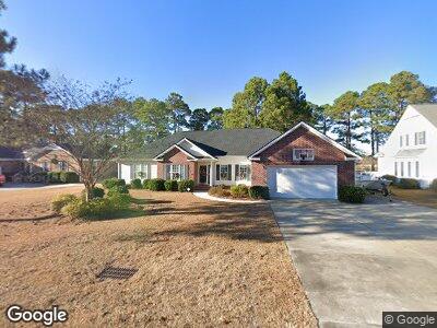
124 Furman Cir Conway, SC 29526
Estimated Value: $394,000 - $481,694
4
Beds
3
Baths
2,406
Sq Ft
$181/Sq Ft
Est. Value
About This Home
This home is located at 124 Furman Cir, Conway, SC 29526 and is currently estimated at $435,674, approximately $181 per square foot. 124 Furman Cir is a home located in Horry County with nearby schools including Palmetto Bays Elementary School, Black Water Middle School, and Carolina Forest High School.
Ownership History
Date
Name
Owned For
Owner Type
Purchase Details
Closed on
May 28, 2008
Sold by
Wild Wing Co Llc
Bought by
Poston Robin H
Current Estimated Value
Home Financials for this Owner
Home Financials are based on the most recent Mortgage that was taken out on this home.
Original Mortgage
$140,250
Outstanding Balance
$91,790
Interest Rate
6.02%
Mortgage Type
Credit Line Revolving
Estimated Equity
$343,884
Purchase Details
Closed on
Jun 11, 2004
Sold by
Spivey Richard Allen
Bought by
Huggins Poston John Robert and Huggins Poston Robin
Home Financials for this Owner
Home Financials are based on the most recent Mortgage that was taken out on this home.
Original Mortgage
$44,150
Interest Rate
6.3%
Mortgage Type
Purchase Money Mortgage
Create a Home Valuation Report for This Property
The Home Valuation Report is an in-depth analysis detailing your home's value as well as a comparison with similar homes in the area
Home Values in the Area
Average Home Value in this Area
Purchase History
| Date | Buyer | Sale Price | Title Company |
|---|---|---|---|
| Poston Robin H | $165,000 | -- | |
| Huggins Poston John Robert | $49,000 | -- |
Source: Public Records
Mortgage History
| Date | Status | Borrower | Loan Amount |
|---|---|---|---|
| Open | Poston Robin H | $140,250 | |
| Previous Owner | Poston John R | $233,650 | |
| Previous Owner | Poston John R | $275,000 | |
| Previous Owner | Huggins Poston John Robert | $44,150 | |
| Previous Owner | Funk David M | $80,000 |
Source: Public Records
Tax History Compared to Growth
Tax History
| Year | Tax Paid | Tax Assessment Tax Assessment Total Assessment is a certain percentage of the fair market value that is determined by local assessors to be the total taxable value of land and additions on the property. | Land | Improvement |
|---|---|---|---|---|
| 2024 | $1,256 | $11,038 | $1,590 | $9,448 |
| 2023 | $1,256 | $11,038 | $1,590 | $9,448 |
| 2021 | $1,134 | $11,038 | $1,590 | $9,448 |
| 2020 | $1,005 | $11,038 | $1,590 | $9,448 |
| 2019 | $1,051 | $11,038 | $1,590 | $9,448 |
| 2018 | $946 | $10,058 | $1,398 | $8,660 |
| 2017 | $931 | $10,058 | $1,398 | $8,660 |
| 2016 | -- | $10,058 | $1,398 | $8,660 |
| 2015 | $931 | $10,058 | $1,398 | $8,660 |
| 2014 | $858 | $10,058 | $1,398 | $8,660 |
Source: Public Records
Map
Nearby Homes
- 185 Lander Dr
- 500 Myrtle Greens Dr Unit D
- 500 Myrtle Greens Dr Unit A
- 205 Lander Dr
- 100 Myrtle Greens Dr Unit G
- 215 Lander Dr
- 138 Wofford Rd
- 380 Myrtle Greens Dr Unit D
- 380 Myrtle Greens Dr Unit 380
- 380 Myrtle Greens Dr Unit E
- Lot 11 Professional Park Dr
- 221 Lander Dr
- 650 Woodman Dr
- 1112 Raven Cliff Ct
- 160 Cart Crossing Dr Unit 104
- 109 Clemson Rd
- 4 Clemson Rd
- 500 Willow Green Dr Unit B
- 202 Glenwood Dr
- 799 Helms Way