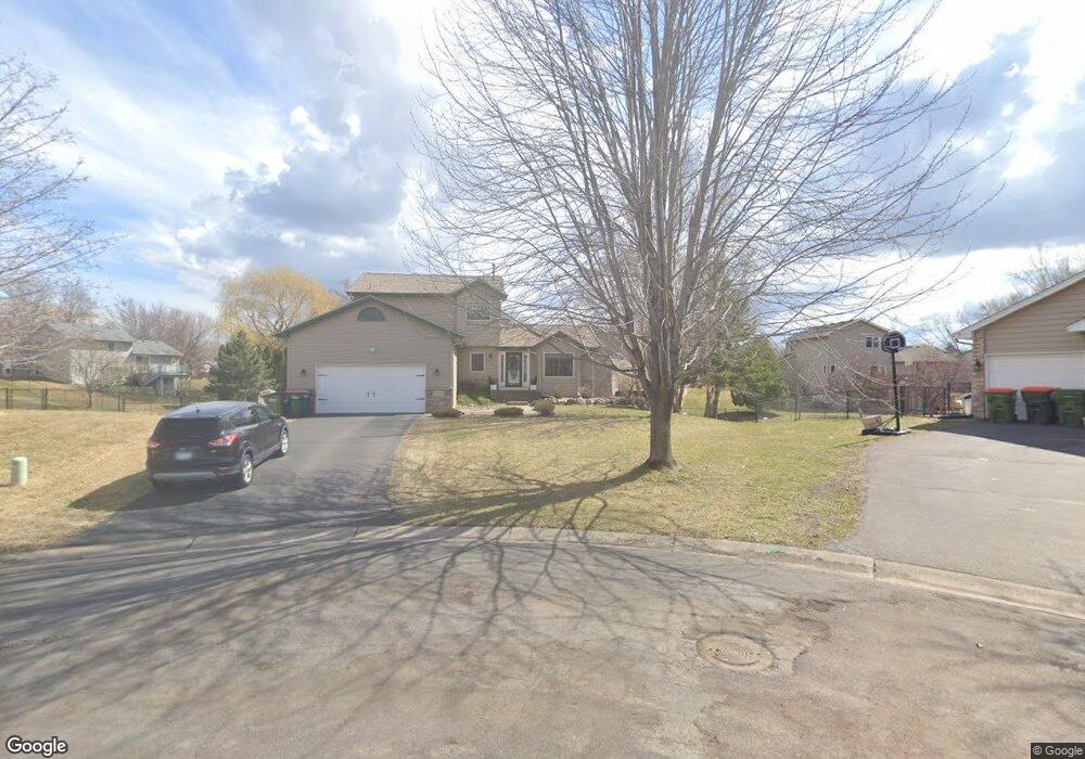
12411 Swallow Cir NW Coon Rapids, MN 55448
Estimated Value: $445,464 - $500,000
5
Beds
4
Baths
2,992
Sq Ft
$158/Sq Ft
Est. Value
About This Home
This home is located at 12411 Swallow Cir NW, Coon Rapids, MN 55448 and is currently estimated at $473,116, approximately $158 per square foot. 12411 Swallow Cir NW is a home located in Anoka County with nearby schools including Lucile Bruner Elementary School, Hoover Elementary School, and Laughlin Junior/Senior High School.
Ownership History
Date
Name
Owned For
Owner Type
Purchase Details
Closed on
Jan 13, 2016
Sold by
Radtke Wilbert Wilbert
Bought by
Shasky Jonathan Jonathan
Current Estimated Value
Home Financials for this Owner
Home Financials are based on the most recent Mortgage that was taken out on this home.
Original Mortgage
$269,037
Outstanding Balance
$214,041
Interest Rate
3.97%
Estimated Equity
$259,075
Purchase Details
Closed on
Jun 11, 2008
Sold by
Leon Ginger and Leon Ruben
Bought by
Radtke Kathleen A and Radtke Wilbert F
Home Financials for this Owner
Home Financials are based on the most recent Mortgage that was taken out on this home.
Original Mortgage
$231,200
Interest Rate
5.96%
Mortgage Type
New Conventional
Purchase Details
Closed on
Aug 9, 1999
Sold by
Shade Tree Construction Inc
Bought by
Hennessey John P and Romanoski Darcy S
Create a Home Valuation Report for This Property
The Home Valuation Report is an in-depth analysis detailing your home's value as well as a comparison with similar homes in the area
Home Values in the Area
Average Home Value in this Area
Purchase History
| Date | Buyer | Sale Price | Title Company |
|---|---|---|---|
| Shasky Jonathan Jonathan | $274,000 | -- | |
| Radtke Kathleen A | $289,000 | -- | |
| Hennessey John P | $178,000 | -- |
Source: Public Records
Mortgage History
| Date | Status | Borrower | Loan Amount |
|---|---|---|---|
| Open | Shasky Jonathan Jonathan | $269,037 | |
| Previous Owner | Radtke Kathleen A | $231,200 |
Source: Public Records
Tax History Compared to Growth
Tax History
| Year | Tax Paid | Tax Assessment Tax Assessment Total Assessment is a certain percentage of the fair market value that is determined by local assessors to be the total taxable value of land and additions on the property. | Land | Improvement |
|---|---|---|---|---|
| 2025 | $4,634 | $421,600 | $94,800 | $326,800 |
| 2024 | $4,634 | $433,400 | $104,800 | $328,600 |
| 2023 | $4,206 | $430,300 | $90,400 | $339,900 |
| 2022 | $3,720 | $424,000 | $77,200 | $346,800 |
| 2021 | $3,715 | $335,700 | $65,100 | $270,600 |
| 2020 | $3,869 | $327,600 | $69,500 | $258,100 |
| 2019 | $3,647 | $326,500 | $73,900 | $252,600 |
| 2018 | $3,558 | $300,300 | $0 | $0 |
| 2017 | $3,194 | $284,600 | $0 | $0 |
| 2016 | $3,216 | $249,700 | $0 | $0 |
| 2015 | -- | $249,700 | $56,100 | $193,600 |
| 2014 | -- | $224,700 | $55,300 | $169,400 |
Source: Public Records
Map
Nearby Homes
- 2147 125th Ln NW
- 2068 124th Ln NW
- 12760 Raven St NW
- 1930 127th Cir NW
- 2675 128th Ave NW
- 12365 Jay St NW
- 12888 Nightingale St NW
- 12019 Zion St NW
- 1727 121st Ln NW
- 12554 Grouse St NW
- 12759 Ibis St NW
- 1593 126th Ln NW
- 12463 Drake St NW
- 1450 126th Ln NW
- 11749 Crooked Lake Blvd NW
- 12010 Eagle St NW
- 13182 Zion St NW
- 1520 129th Ave NW
- 3074 121st Ave NW
- 1687 131st Ln NW
- 12425 Swallow Cir NW
- 12408 Swallow Cir NW
- 12375 Swallow St NW
- 12378 Swallow St NW
- 12361 Swallow St NW
- 12422 Swallow Cir NW
- 12408 Raven St NW
- 12394 Raven St NW
- 12439 Swallow Cir NW
- 12422 Raven St NW
- 12436 Swallow Cir NW
- 12380 Raven St NW
- 12364 Swallow St NW
- 12436 Raven St NW
- 12366 Raven St NW
- 2245 123rd Ln NW
- 12413 Thrush St NW
- 12363 Thrush St NW
- 12357 Thrush St NW
- 12350 Swallow St NW