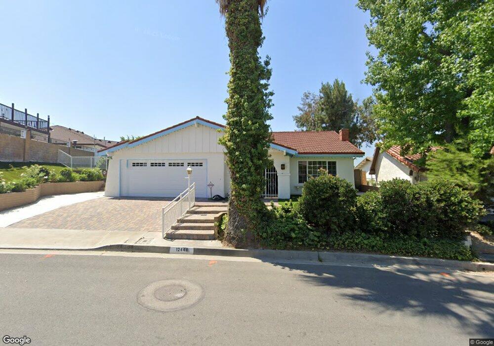
12444 Carinthia Dr Whittier, CA 90601
West Whittier NeighborhoodEstimated Value: $936,000 - $1,085,000
3
Beds
2
Baths
1,788
Sq Ft
$568/Sq Ft
Est. Value
About This Home
This home is located at 12444 Carinthia Dr, Whittier, CA 90601 and is currently estimated at $1,014,844, approximately $567 per square foot. 12444 Carinthia Dr is a home located in Los Angeles County with nearby schools including Longfellow Elementary School, Walter F. Dexter Middle School, and Whittier High School.
Ownership History
Date
Name
Owned For
Owner Type
Purchase Details
Closed on
Mar 27, 2015
Sold by
Flores Maximo and Flores Bertha
Bought by
Gonzalez Maria E and The Bertha Flores Credit Shelt
Current Estimated Value
Purchase Details
Closed on
Sep 21, 1996
Sold by
Flores Maximo N and Flores Bertha P
Bought by
Flores Maximo and Flores Bertha
Create a Home Valuation Report for This Property
The Home Valuation Report is an in-depth analysis detailing your home's value as well as a comparison with similar homes in the area
Home Values in the Area
Average Home Value in this Area
Purchase History
| Date | Buyer | Sale Price | Title Company |
|---|---|---|---|
| Gonzalez Maria E | -- | None Available | |
| Flores Maximo | -- | -- |
Source: Public Records
Tax History Compared to Growth
Tax History
| Year | Tax Paid | Tax Assessment Tax Assessment Total Assessment is a certain percentage of the fair market value that is determined by local assessors to be the total taxable value of land and additions on the property. | Land | Improvement |
|---|---|---|---|---|
| 2025 | $5,413 | $419,415 | $159,290 | $260,125 |
| 2024 | $5,413 | $411,192 | $156,167 | $255,025 |
| 2023 | $5,268 | $403,130 | $153,105 | $250,025 |
| 2022 | $5,121 | $395,226 | $150,103 | $245,123 |
| 2021 | $5,008 | $387,477 | $147,160 | $240,317 |
| 2019 | $4,886 | $375,987 | $142,797 | $233,190 |
| 2018 | $4,655 | $368,616 | $139,998 | $228,618 |
| 2016 | $4,547 | $354,304 | $134,562 | $219,742 |
| 2015 | $4,484 | $348,983 | $132,541 | $216,442 |
| 2014 | $4,394 | $342,148 | $129,945 | $212,203 |
Source: Public Records
Map
Nearby Homes
- 12429 Floral Dr
- 5655 Pickering Ave
- 5522 Greenleaf Ave
- 12417 Rose Dr
- 12831 Stardell St
- 11759 S Circle Dr
- 11840 Nixon Ln
- 5840 Citrus Ave
- 11905 Mendenhall Ln
- 12031 Beverly Blvd Unit 1D
- 5516 Palm Ave
- 11514 Beverly Blvd
- 5827 Washington Ave
- 11422 Ridgegate Dr
- 11338 Ridgegate Dr
- 5307 Woodward Ln
- 12512 Broadway
- 11849 Cog Hill Dr
- 11951 Rustic Hill Dr
- 6217 Greenleaf Ave
- 12508 Mount Holly Dr
- 12436 Carinthia Dr
- 12450 Carinthia Dr
- 12432 Carinthia Dr
- 12510 Mount Holly Dr
- 12437 Carinthia Dr
- 12447 Carinthia Dr
- 0 Honolulu Trail Unit CV15102229
- 0 Honolulu Trail Unit P630411
- 12427 Carinthia Dr
- 12502 Carinthia Dr
- 12424 Carinthia Dr
- 12455 Carinthia Dr
- 12503 Carinthia Dr
- 12413 Honolulu Terrace
- 12419 Honolulu Terrace
- 12407 Honolulu Terrace
- 12416 Carinthia Dr
- 12520 Mount Holly Dr
- 12425 Honolulu Terrace