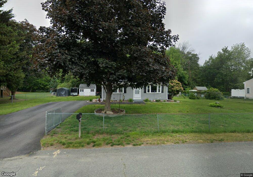
125 Hubbard Ave Brockton, MA 02301
Campello NeighborhoodEstimated Value: $451,000 - $513,000
3
Beds
1
Bath
952
Sq Ft
$517/Sq Ft
Est. Value
About This Home
This home is located at 125 Hubbard Ave, Brockton, MA 02301 and is currently estimated at $491,992, approximately $516 per square foot. 125 Hubbard Ave is a home located in Plymouth County with nearby schools including Davis K-8 School, John F. Kennedy Elementary School, and South Middle School.
Ownership History
Date
Name
Owned For
Owner Type
Purchase Details
Closed on
Jul 2, 2008
Sold by
Wachovia Bk
Bought by
Woo Darlene
Current Estimated Value
Purchase Details
Closed on
May 2, 2008
Sold by
Gurnon Robert T
Bought by
Wachovia Bk and Specialized Loan Serv
Purchase Details
Closed on
Jan 12, 2005
Sold by
Mainini Mary
Bought by
Gurnon Robert T and Gurnon Robert K
Purchase Details
Closed on
Aug 26, 2004
Sold by
Chery Joseph E and Chery Linouse H
Bought by
Mainini Mary
Purchase Details
Closed on
Mar 26, 1991
Sold by
Equibank
Bought by
Devito Edward R and Devito Jolyn
Create a Home Valuation Report for This Property
The Home Valuation Report is an in-depth analysis detailing your home's value as well as a comparison with similar homes in the area
Home Values in the Area
Average Home Value in this Area
Purchase History
| Date | Buyer | Sale Price | Title Company |
|---|---|---|---|
| Woo Darlene | $167,000 | -- | |
| Wachovia Bk | $172,404 | -- | |
| Gurnon Robert T | $265,000 | -- | |
| Mainini Mary | $194,000 | -- | |
| Devito Edward R | $107,000 | -- |
Source: Public Records
Mortgage History
| Date | Status | Borrower | Loan Amount |
|---|---|---|---|
| Open | Devito Edward R | $153,000 |
Source: Public Records
Tax History Compared to Growth
Tax History
| Year | Tax Paid | Tax Assessment Tax Assessment Total Assessment is a certain percentage of the fair market value that is determined by local assessors to be the total taxable value of land and additions on the property. | Land | Improvement |
|---|---|---|---|---|
| 2025 | $5,167 | $426,700 | $164,300 | $262,400 |
| 2024 | $4,837 | $402,400 | $164,300 | $238,100 |
| 2023 | $4,909 | $378,200 | $114,800 | $263,400 |
| 2022 | $4,716 | $337,600 | $104,400 | $233,200 |
| 2021 | $4,244 | $292,700 | $98,200 | $194,500 |
| 2020 | $4,378 | $289,000 | $85,600 | $203,400 |
| 2019 | $4,196 | $270,000 | $82,300 | $187,700 |
| 2018 | $3,923 | $244,300 | $82,300 | $162,000 |
| 2017 | $3,663 | $227,500 | $82,300 | $145,200 |
| 2016 | $3,439 | $198,100 | $78,400 | $119,700 |
| 2015 | $3,218 | $177,300 | $78,400 | $98,900 |
| 2014 | $3,247 | $179,100 | $78,400 | $100,700 |
Source: Public Records
Map
Nearby Homes
- 358 Copeland St
- 13 Finny's Way
- 15 Longworth Ave Unit 231
- 15 Fieldstone Dr
- 35 Longworth Ave Unit 17
- 1 Fairway Dr
- 47 Southworth St
- 21 Roosevelt Ave
- 163 S Leyden St
- 16 Friendship Dr
- 115 Market St
- 223 Clinton St Unit 10
- 223 Clinton St Unit 3
- 18 American Ave
- 65 Tremont St
- 1036 Ash St
- 137 Channing Ave
- 977 Warren Ave
- 139 Geralynn Dr
- 122 Sinclair Rd
- 133 Hubbard Ave
- 115 Hubbard Ave
- 126 Hubbard Ave
- 130 Hubbard Ave
- 110 Hubbard Ave
- 104 Hubbard Ave
- 137 Hubbard Ave
- 67 Glendale Ave
- 71 Glendale Ave
- 138 Hubbard Ave
- 63 Glendale Ave
- 77 Glendale Ave
- 81 Glendale Ave
- 57 Glendale Ave
- 141 Hubbard Ave
- 142 Hubbard Ave
- 95 Hubbard Ave
- 87 Glendale Ave
- 147 Hubbard Ave
- 148 Hubbard Ave