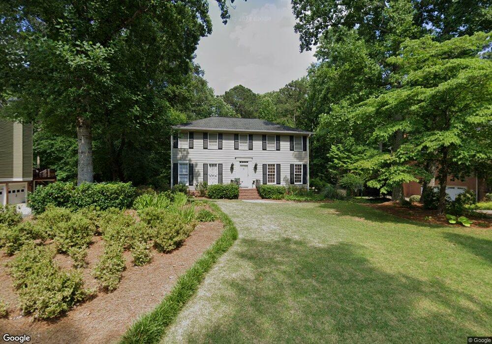
125 Millbrook Trace Unit 2 Marietta, GA 30068
East Cobb NeighborhoodEstimated Value: $564,182 - $620,000
4
Beds
4
Baths
2,334
Sq Ft
$250/Sq Ft
Est. Value
About This Home
This home is located at 125 Millbrook Trace Unit 2, Marietta, GA 30068 and is currently estimated at $583,546, approximately $250 per square foot. 125 Millbrook Trace Unit 2 is a home located in Cobb County with nearby schools including Eastvalley Elementary School, East Cobb Middle School, and Wheeler High School.
Ownership History
Date
Name
Owned For
Owner Type
Purchase Details
Closed on
Jun 20, 1997
Sold by
Carter Hoke B and Carter Gloria
Bought by
Obrien Joanne
Current Estimated Value
Home Financials for this Owner
Home Financials are based on the most recent Mortgage that was taken out on this home.
Original Mortgage
$153,200
Outstanding Balance
$20,856
Interest Rate
7.93%
Mortgage Type
New Conventional
Estimated Equity
$562,690
Create a Home Valuation Report for This Property
The Home Valuation Report is an in-depth analysis detailing your home's value as well as a comparison with similar homes in the area
Home Values in the Area
Average Home Value in this Area
Purchase History
| Date | Buyer | Sale Price | Title Company |
|---|---|---|---|
| Obrien Joanne | $191,500 | -- |
Source: Public Records
Mortgage History
| Date | Status | Borrower | Loan Amount |
|---|---|---|---|
| Open | Obrien Joanne | $153,200 |
Source: Public Records
Tax History Compared to Growth
Tax History
| Year | Tax Paid | Tax Assessment Tax Assessment Total Assessment is a certain percentage of the fair market value that is determined by local assessors to be the total taxable value of land and additions on the property. | Land | Improvement |
|---|---|---|---|---|
| 2025 | $1,219 | $189,700 | $46,000 | $143,700 |
| 2024 | $1,223 | $189,700 | $46,000 | $143,700 |
| 2023 | $1,019 | $190,280 | $36,000 | $154,280 |
| 2022 | $3,776 | $151,180 | $36,000 | $115,180 |
| 2021 | $3,776 | $151,180 | $36,000 | $115,180 |
| 2020 | $3,607 | $143,436 | $36,000 | $107,436 |
| 2019 | $3,046 | $117,828 | $36,000 | $81,828 |
| 2018 | $3,001 | $115,768 | $24,000 | $91,768 |
| 2017 | $2,881 | $115,768 | $24,000 | $91,768 |
| 2016 | $2,642 | $104,772 | $24,000 | $80,772 |
| 2015 | $2,703 | $104,772 | $24,000 | $80,772 |
| 2014 | $2,456 | $92,784 | $0 | $0 |
Source: Public Records
Map
Nearby Homes
- 2851 Dale Dr
- 2811 Georgian Terrace Unit 5
- 2790 Burtz Dr
- 29 Rhodes Dr
- 11 Cecil Dr
- 302 Chase Ln
- 61 Holt Rd NE
- 470 Manor Oak Ln SE
- 15 Vickwood Ct NE
- 2431 Weatherford Ct
- 180 Blue Sky Dr
- 2490 Freydale Rd SE
- 2827 Beverly Hills Dr NE
- 2514 Sunny Ln SE
- 560 Park Ln SE
- 654 Grove Pkwy SE
- 2310 Old Sewell Rd
- 489 Little Rd SE
- 3270 Brookview Dr
- 3048 Haverford Ln SE
- 135 Millbrook Trace
- 115 Millbrook Trace
- 105 Millbrook Trace
- 145 Millbrook Trace
- 130 Millbrook Trace Unit 2
- 140 Millbrook Trace Unit 2
- 120 Millbrook Trace
- 17 Brookcrest Dr
- 175 Millbrook Trace Unit 2
- 110 Millbrook Trace
- 95 Millbrook Trace Unit 2
- 158 Millbrook Farm Rd
- 170 Millbrook Trace
- 100 Millbrook Trace
- 215 Millbrook Trace
- 172 Millbrook Farm Rd
- 90 Millbrook Trace
- 2731 Georgian Terrace
- 200 Millbrook Trace Unit 2
- 10 Brookcrest Dr Unit 2