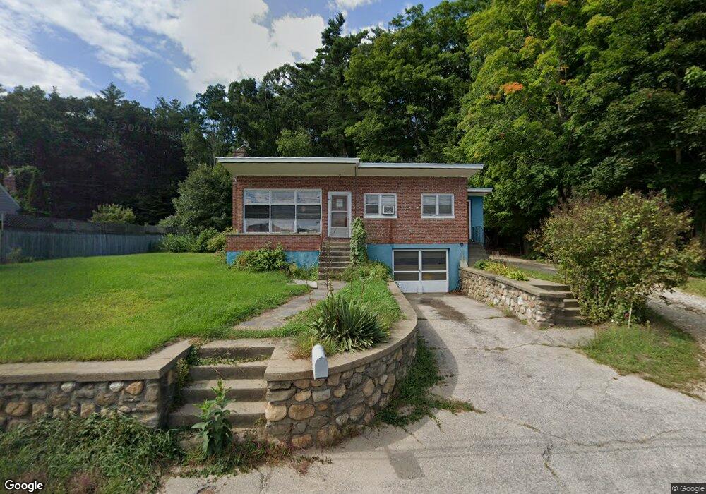
125 Route 27 Raymond, NH 03077
Estimated Value: $375,000 - $465,000
2
Beds
1
Bath
1,014
Sq Ft
$401/Sq Ft
Est. Value
About This Home
This home is located at 125 Route 27, Raymond, NH 03077 and is currently estimated at $406,657, approximately $401 per square foot. 125 Route 27 is a home located in Rockingham County with nearby schools including Lamprey River Elementary School, Iber Holmes Gove Middle School, and Raymond High School.
Ownership History
Date
Name
Owned For
Owner Type
Purchase Details
Closed on
Mar 24, 2000
Sold by
Doherty Est Robert P
Bought by
Elliott Charles H and Elliott Mary J
Current Estimated Value
Home Financials for this Owner
Home Financials are based on the most recent Mortgage that was taken out on this home.
Original Mortgage
$21,600
Outstanding Balance
$7,331
Interest Rate
8.31%
Estimated Equity
$399,326
Create a Home Valuation Report for This Property
The Home Valuation Report is an in-depth analysis detailing your home's value as well as a comparison with similar homes in the area
Home Values in the Area
Average Home Value in this Area
Purchase History
| Date | Buyer | Sale Price | Title Company |
|---|---|---|---|
| Elliott Charles H | $108,000 | -- |
Source: Public Records
Mortgage History
| Date | Status | Borrower | Loan Amount |
|---|---|---|---|
| Open | Elliott Charles H | $21,600 |
Source: Public Records
Tax History Compared to Growth
Tax History
| Year | Tax Paid | Tax Assessment Tax Assessment Total Assessment is a certain percentage of the fair market value that is determined by local assessors to be the total taxable value of land and additions on the property. | Land | Improvement |
|---|---|---|---|---|
| 2024 | $5,059 | $230,900 | $85,600 | $145,300 |
| 2023 | $4,784 | $230,900 | $85,600 | $145,300 |
| 2022 | $4,223 | $230,900 | $85,600 | $145,300 |
| 2021 | $4,274 | $230,900 | $85,600 | $145,300 |
| 2020 | $4,485 | $171,200 | $61,200 | $110,000 |
| 2019 | $4,552 | $171,200 | $61,200 | $110,000 |
| 2018 | $4,511 | $171,200 | $61,200 | $110,000 |
| 2017 | $4,143 | $171,200 | $61,200 | $110,000 |
| 2016 | $4,064 | $171,200 | $61,200 | $110,000 |
| 2015 | $4,008 | $159,800 | $61,200 | $98,600 |
| 2014 | $3,888 | $159,800 | $61,200 | $98,600 |
| 2013 | $3,778 | $159,800 | $61,200 | $98,600 |
Source: Public Records
Map
Nearby Homes
- 29 Harriman Rd
- 81 Main St
- 84 W Shore Dr
- 7 Woodlawn Rd
- 189 Route 27
- 6 Knights Ct
- 202 Route 27 Unit 36
- 88 Harriman Hill Rd
- 29 Glen Ridge Rd
- 19 Parker Ave
- 10 Raiders Ln
- 29 Batchelder Rd
- 0 Eastside Dr
- 53 Barberry Ln
- 3 Mica Dr Unit 1
- 112 Harriman Hill Rd
- 17 Old Fremont Rd
- 11 Ham Rd
- 11 Blaisdell's Trail
- 6 Blaisdell's Trail