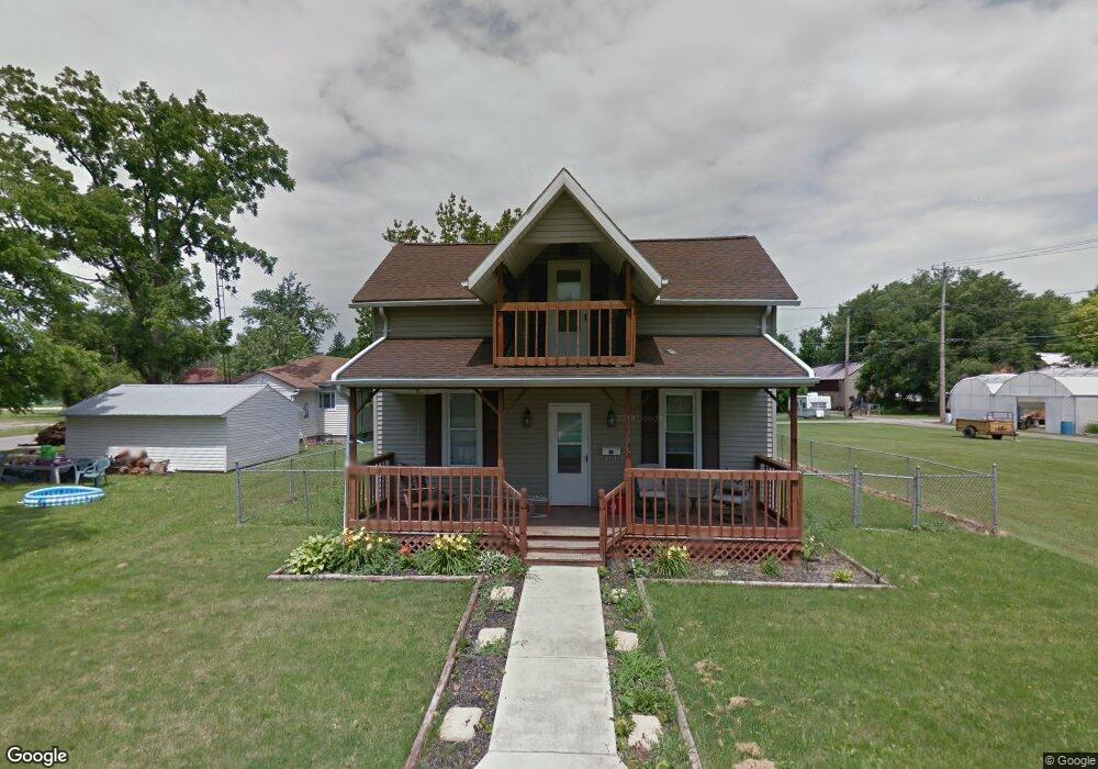
126 W Letson St Kenton, OH 43326
Estimated Value: $109,000 - $146,000
3
Beds
1
Bath
1,312
Sq Ft
$98/Sq Ft
Est. Value
About This Home
This home is located at 126 W Letson St, Kenton, OH 43326 and is currently estimated at $129,007, approximately $98 per square foot. 126 W Letson St is a home located in Hardin County with nearby schools including Kenton Elementary School, Kenton Middle School, and Kenton High School.
Ownership History
Date
Name
Owned For
Owner Type
Purchase Details
Closed on
Nov 13, 2013
Sold by
Bolen Danielle
Bought by
Bolen John
Current Estimated Value
Purchase Details
Closed on
Jun 10, 2004
Bought by
Abn Amro Mortgage Group and Bolen Danielle M
Purchase Details
Closed on
Jan 15, 2004
Bought by
Federal Home Loan Mortg
Purchase Details
Closed on
Apr 9, 1999
Bought by
Roby James and Roby Regina A
Purchase Details
Closed on
Mar 5, 1993
Bought by
Weaver Phillip
Purchase Details
Closed on
Jul 15, 1992
Purchase Details
Closed on
Dec 17, 1985
Create a Home Valuation Report for This Property
The Home Valuation Report is an in-depth analysis detailing your home's value as well as a comparison with similar homes in the area
Home Values in the Area
Average Home Value in this Area
Purchase History
| Date | Buyer | Sale Price | Title Company |
|---|---|---|---|
| Bolen John | -- | None Available | |
| Abn Amro Mortgage Group | -- | -- | |
| Federal Home Loan Mortg | $38,000 | -- | |
| Roby James | $30,000 | -- | |
| Weaver Phillip | -- | -- | |
| -- | $14,400 | -- | |
| -- | $21,800 | -- |
Source: Public Records
Tax History Compared to Growth
Tax History
| Year | Tax Paid | Tax Assessment Tax Assessment Total Assessment is a certain percentage of the fair market value that is determined by local assessors to be the total taxable value of land and additions on the property. | Land | Improvement |
|---|---|---|---|---|
| 2024 | $1,451 | $32,580 | $1,790 | $30,790 |
| 2023 | $1,361 | $32,580 | $1,790 | $30,790 |
| 2022 | $1,176 | $24,710 | $1,260 | $23,450 |
| 2021 | $1,180 | $24,710 | $1,260 | $23,450 |
| 2020 | $1,129 | $24,710 | $1,260 | $23,450 |
| 2019 | $2,086 | $20,410 | $1,200 | $19,210 |
| 2018 | $937 | $20,410 | $1,200 | $19,210 |
| 2017 | $11,978 | $20,410 | $1,200 | $19,210 |
| 2016 | $787 | $16,340 | $1,320 | $15,020 |
| 2015 | $572 | $15,440 | $1,320 | $14,120 |
| 2014 | $6,707 | $15,440 | $1,320 | $14,120 |
| 2013 | $4,596 | $17,000 | $1,320 | $15,680 |
Source: Public Records
Map
Nearby Homes
- 727 S Detroit St
- 639 S Main St
- 320 Letson Ave
- 508 Decatur St
- 510 Decatur St
- 414 Robinson Ave
- 121 S High St
- 920 Cooper St
- 530 E Franklin St
- 513 E Franklin St
- 115 Scioto St
- 39 Grape St
- 219 W Carrol St
- 79 Broadway St
- 509 E Carrol St
- 215 N Main St
- 13450 State Route 292
- 726 Tracy St
- 233 N Main St
- 702 W Franklin St Unit 702 1/2
- 127 W Letson St
- 841 S Detroit St
- 837 S Detroit St
- 833 S Detroit St
- 856 S Main St
- 910 S Main St
- 825 S Detroit St
- 826 S Detroit St
- 902 S Main St
- 821 S Detroit St
- 930 S Detroit St
- 923 S Detroit St
- 859 S Main St
- 818 S Detroit St
- 815 Detroit S(p)
- 855 S Main St
- 842 S Main St
- 220 W Letson St
- 815 S Detroit St