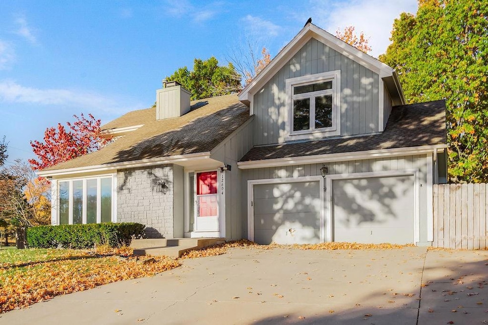
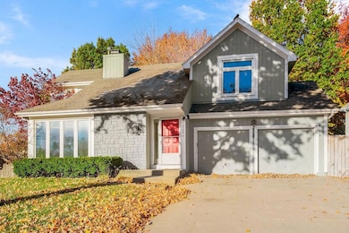

12604 S Brougham Dr Olathe, KS 66062
Estimated payment $2,571/month
Highlights
- Spa
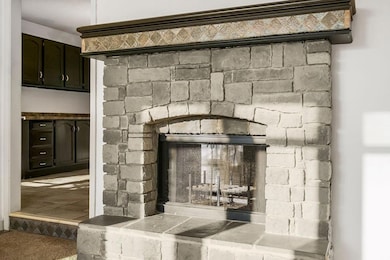
- Fireplace in Kitchen
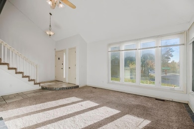
- Vaulted Ceiling
- Olathe East Sr High School Rated A-
- Deck
- Separate Formal Living Room
About This Home
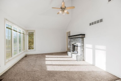
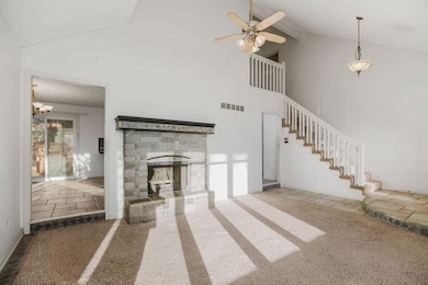
Welcome home! You're looking at one of the best-valued homes in all of Olathe, filled with upgraded features and amenities! As you step inside the home, you're welcomed to a vaulted living room with a beautiful stone fireplace, naturally lit by large windows. The home seamlessly flows, as the dining room and large kitchen are right on the other side. You don't want to miss the fact that you can enjoy that same fireplace from both the kitchen and living room, giving the house a seamless flow. From there, step outside to the deck/hottub combo - a perfect addition for the upcoming fall and winter. Soak there and enjoy the spacious backyard. Don't miss the newer driveway on the front of the home either! Come back inside and step up to the four spacious bedrooms upstairs. The house keeps its interconnected feel as you can overlook everything from the catwalk connecting all of your rooms! In the basement, don't miss the wet bar, an additional living space, and a non-conforming FIFTH bedroom! This house is truly massive! The seller is open to all types of financing, and with an agreeable offer, would be willing to put on a new roof! Don't miss your chance to make this one YOURS!
Listing Agent
Platinum Realty LLC Brokerage Phone: 626-226-6611 License #2021020794 Listed on: 10/17/2025

Home Details
Home Type
- Single Family
Est. Annual Taxes
- $4,319
Year Built
- Built in 1986
Lot Details
- 9,344 Sq Ft Lot
- Privacy Fence
- Aluminum or Metal Fence
- Corner Lot
Parking
- 2 Car Attached Garage
- Front Facing Garage
Interior Spaces
- 2,045 Sq Ft Home
- 2-Story Property
- Wet Bar
- Vaulted Ceiling
- Ceiling Fan
- See Through Fireplace
- Thermal Windows
- Family Room with Fireplace
- Separate Formal Living Room
- Combination Kitchen and Dining Room
- Home Security System
- Laundry on main level
Kitchen
- Built-In Oven
- Dishwasher
- Kitchen Island
- Disposal
- Fireplace in Kitchen
Flooring
- Carpet
- Ceramic Tile
Bedrooms and Bathrooms
- 4 Bedrooms
- Walk-In Closet
- Double Vanity
Finished Basement
- Basement Fills Entire Space Under The House
- Bedroom in Basement
Outdoor Features
- Spa
- Deck
Utilities
- Central Air
Community Details
- No Home Owners Association
- Cambridge Point Subdivision
Listing and Financial Details
- Assessor Parcel Number DP10400000 0036
- $0 special tax assessment
Map
Home Values in the Area
Average Home Value in this Area
Tax History
| Year | Tax Paid | Tax Assessment Tax Assessment Total Assessment is a certain percentage of the fair market value that is determined by local assessors to be the total taxable value of land and additions on the property. | Land | Improvement |
|---|---|---|---|---|
| 2024 | $4,319 | $38,571 | $6,515 | $32,056 |
| 2023 | $4,172 | $36,478 | $5,664 | $30,814 |
| 2022 | $3,803 | $32,373 | $5,664 | $26,709 |
| 2021 | $3,928 | $30,786 | $5,152 | $25,634 |
| 2020 | $3,588 | $28,808 | $4,476 | $24,332 |
| 2019 | $3,471 | $27,692 | $4,476 | $23,216 |
| 2018 | $2,992 | $26,496 | $4,066 | $22,430 |
| 2017 | $3,058 | $24,001 | $3,534 | $20,467 |
| 2016 | $2,779 | $22,391 | $3,534 | $18,857 |
| 2015 | $2,640 | $21,298 | $3,534 | $17,764 |
| 2013 | -- | $20,240 | $3,375 | $16,865 |
Property History
| Date | Event | Price | List to Sale | Price per Sq Ft |
|---|---|---|---|---|
| 11/13/2025 11/13/25 | For Sale | $420,000 | -- | $205 / Sq Ft |
Purchase History
| Date | Type | Sale Price | Title Company |
|---|---|---|---|
| Warranty Deed | -- | First American Title Ins Co |
Mortgage History
| Date | Status | Loan Amount | Loan Type |
|---|---|---|---|
| Open | $184,000 | New Conventional |
Source: Heartland MLS
MLS Number: 2582592
APN: DP10400000-0036
Disclaimer: Certain information contained herein is derived from information provided by parties other than Homes.com. All information provided is deemed reliable, but is not guaranteed to be accurate and should be independently verified.
![]() Based on information submitted to the MLS GRID as of [see last changed date above]. All data is obtained from various sources and may not have been verified by broker or MLS GRID. Supplied Open House Information is subject to change without notice. All information should be independently reviewed and verified for accuracy. Properties may or may not be listed by the office/agent presenting the information. Some IDX listings have been excluded from this website. Prices displayed on all Sold listings are the Last Known Listing Price and may not be the actual selling price.
Based on information submitted to the MLS GRID as of [see last changed date above]. All data is obtained from various sources and may not have been verified by broker or MLS GRID. Supplied Open House Information is subject to change without notice. All information should be independently reviewed and verified for accuracy. Properties may or may not be listed by the office/agent presenting the information. Some IDX listings have been excluded from this website. Prices displayed on all Sold listings are the Last Known Listing Price and may not be the actual selling price.
Listing Information presented by local MLS brokerage: TEN-X, INC., local REALTOR®- Arlene Richardson - (888)952-6393
The Digital Millennium Copyright Act of 1998, 17 U.S.C. § 512 (the “DMCA”) provides recourse for copyright owners who believe that material appearing on the Internet infringes their rights under U.S. copyright law. If you believe in good faith that any content or material made available in connection with our website or services infringes your copyright, you (or your agent) may send us a notice requesting that the content or material be removed, or access to it blocked.
Notices must be sent in writing by email to DMCAnotice@MLSGrid.com.
The DMCA requires that your notice of alleged copyright infringement include the following information:
(1) description of the copyrighted work that is the subject of claimed infringement;
(2) description of the alleged infringing content and information sufficient to permit us to locate the content;
(3) contact information for you, including your address, telephone number and email address;
(4) a statement by you that you have a good faith belief that the content in the manner complained of is not authorized by the copyright owner, or its agent, or by the operation of any law;
(5) a statement by you, signed under penalty of perjury, that the information in the notification is accurate and that you have the authority to enforce the copyrights that are claimed to be infringed; and
(6) a physical or electronic signature of the copyright owner or a person authorized to act on the copyright owner’s behalf. Failure to include all of the above information may result in the delay of the processing of your complaint.
- 12537 S Brougham Dr
- 12512 S Brougham Dr
- 15704 W 126th Terrace
- 17378 S Raintree Dr Unit Bldg J Unit 37
- 17366 S Raintree Dr Unit Bldg J Unit 40
- 16220 W 125th Terrace
- 16224 W 125th Terrace
- 15616 W 124th Terrace
- 12533 S Locust St
- 16318 W 124th St
- 16014 S Twilight Ln
- 16047 S Twilight Ln
- 16204 S Twilight Ln
- 16046 S Twilight Ln
- 16030 S Twilight Ln
- 16019 S Twilight Ln
- 16063 S Twilight Ln
- 15982 S Twilight Ln
- 15998 S Twilight Ln
- 15934 S Twilight Ln
- 15901 W 127th St
- 1503 W 128th St
- 12930 Brookfield St
- 12840 S Black Bob Rd
- 12501 S Constance St
- 12251-12289 S Strang Line Rd
- 15502-15532 W 133rd St
- 16110 W 133rd St
- 12105-12235 S Blackbob Rd
- 15841 W Beckett Ln
- 11800 S Shannan St
- 13853 W 123rd St
- 1890 N Lennox St
- 1126 E Elizabeth St
- 1616 E Cedar Place
- 12100 S Pflumm Rd
- 11835 S Fellows St
- 16615 W 139th St
- 1440 E College Way
- 838 E 125th Terrace