Estimated Value: $489,000 - $630,000
4
Beds
3
Baths
1,863
Sq Ft
$318/Sq Ft
Est. Value
About This Home
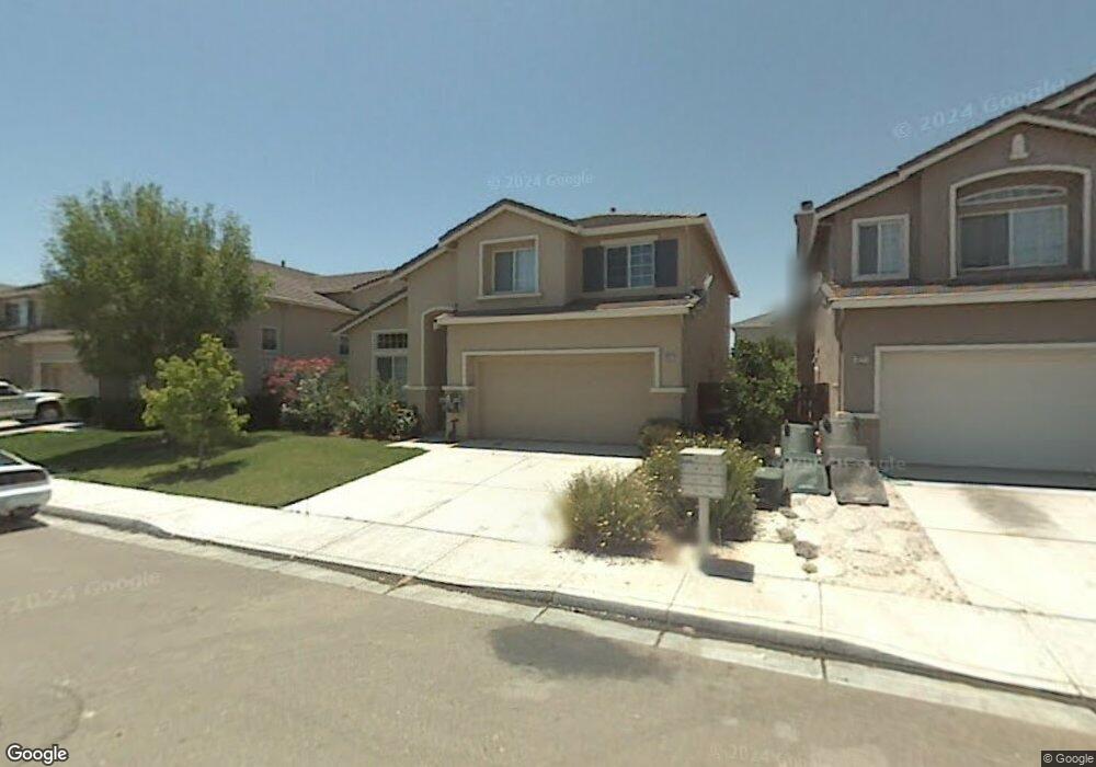
This home is located at 1267 Gentry Ct, Tracy, CA 95377 and is currently estimated at $592,033, approximately $317 per square foot. 1267 Gentry Ct is a home located in San Joaquin County with nearby schools including Melville S. Jacobson Elementary School, Monte Vista Middle School, and Merrill F. West High School.
Ownership History
Date
Name
Owned For
Owner Type
Purchase Details
Closed on
Nov 12, 1999
Sold by
First American Title Ins Co Co
Bought by
Cerny John W
Current Estimated Value
Home Financials for this Owner
Home Financials are based on the most recent Mortgage that was taken out on this home.
Original Mortgage
$185,264
Outstanding Balance
$57,078
Interest Rate
7.87%
Estimated Equity
$534,955
Create a Home Valuation Report for This Property
The Home Valuation Report is an in-depth analysis detailing your home's value as well as a comparison with similar homes in the area
Home Values in the Area
Average Home Value in this Area
Purchase History
We collect this data history from publicly available records. To have your information removed, we recommend requesting removal directly through your county’s website.
| Date | Buyer | Sale Price | Title Company |
|---|---|---|---|
| Cerny John W | $232,000 | First American Title Co |
Source: Public Records
Mortgage History
We collect this data history from publicly available records. To have your information removed, we recommend requesting removal directly through your county’s website.
| Date | Status | Borrower | Loan Amount |
|---|---|---|---|
| Open | Cerny John W | $185,264 |
Source: Public Records
Tax History
| Year | Tax Paid | Tax Assessment Tax Assessment Total Assessment is a certain percentage of the fair market value that is determined by local assessors to be the total taxable value of land and additions on the property. | Land | Improvement |
|---|---|---|---|---|
| 2025 | $4,426 | $356,329 | $122,950 | $233,379 |
| 2024 | $4,098 | $349,343 | $120,540 | $228,803 |
| 2023 | $3,965 | $342,494 | $118,177 | $224,317 |
| 2022 | $4,608 | $335,779 | $115,860 | $219,919 |
| 2021 | $4,676 | $329,196 | $113,589 | $215,607 |
| 2020 | $4,648 | $325,822 | $112,425 | $213,397 |
| 2019 | $4,504 | $319,434 | $110,221 | $209,213 |
| 2018 | $4,434 | $313,171 | $108,060 | $205,111 |
| 2017 | $4,259 | $307,032 | $105,942 | $201,090 |
| 2016 | $4,293 | $301,013 | $103,865 | $197,148 |
| 2014 | $3,976 | $290,684 | $100,301 | $190,383 |
Source: Public Records
Map
Nearby Homes
- 1214 Dover Ln
- 1021 Kennedy Place
- 921 Kennedy Place
- 3030 W Byron Rd
- 2939 Kennsington Ct
- 1723 Duke Ct
- 2780 Oxford Ln
- 2547 Spencer Ln
- 2944 Lyon Ct Unit 2B
- 2834 Hawkins Ct
- 2431 Ogden Sannazor Ct
- 481 Keys Ct
- 1263 Plaza Ct
- 840 Saffron Dr
- 1233 Plaza Ct
- 2236 Sabrina Way
- 2219 Yellowstone Ave
- 2180 Jenni Ln
- 2126 Shenandoah Dr
- 1977 Grove Ct
- 1257 Gentry Ct
- 1277 Gentry Ct
- 1258 Michael Dr
- 1247 Gentry Ct
- 1268 Michael Dr
- 1287 Gentry Ct
- 1248 Michael Dr
- 1278 Michael Dr
- 1266 Gentry Ct
- 1256 Gentry Ct
- 1237 Gentry Ct
- 1276 Gentry Ct
- 1297 Gentry Ct
- 1238 Michael Dr
- 1246 Gentry Ct
- 1286 Gentry Ct
- 1288 Michael Dr
- 1227 Gentry Ct
- 1228 Michael Dr
- 1307 Gentry Ln
Your Personal Tour Guide
Ask me questions while you tour the home.