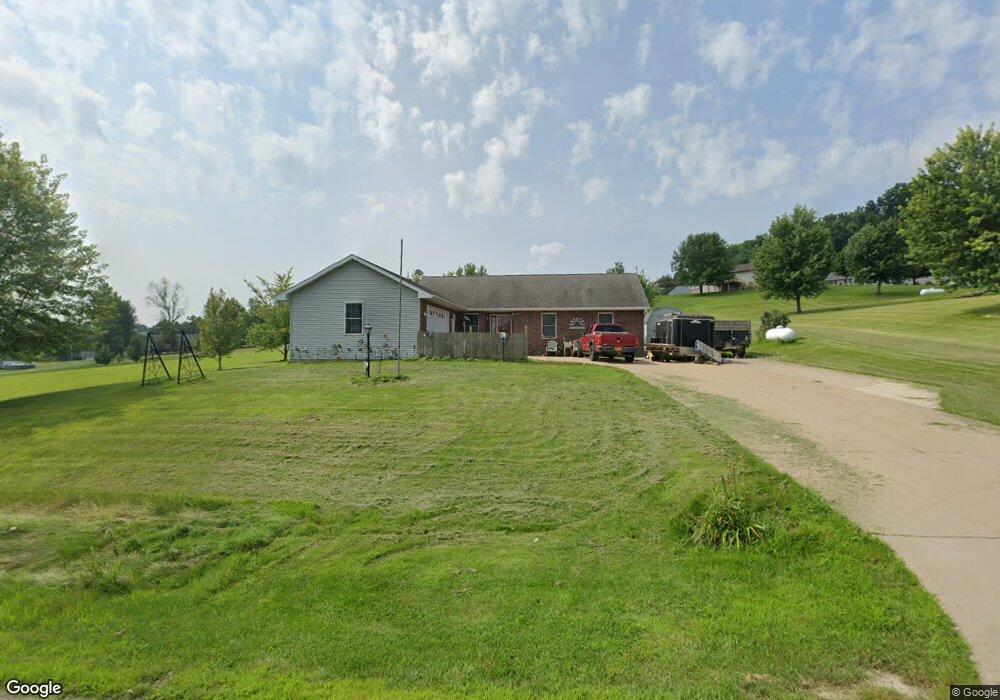
12675 Brentwood Ct Peosta, IA 52068
Estimated Value: $374,538 - $493,000
3
Beds
2
Baths
1,635
Sq Ft
$260/Sq Ft
Est. Value
About This Home
This home is located at 12675 Brentwood Ct, Peosta, IA 52068 and is currently estimated at $424,635, approximately $259 per square foot. 12675 Brentwood Ct is a home located in Dubuque County with nearby schools including Carver Elementary School, Eleanor Roosevelt Middle School, and Hempstead High School.
Ownership History
Date
Name
Owned For
Owner Type
Purchase Details
Closed on
Oct 19, 2005
Sold by
Simon Jerome M
Bought by
Cue Jeffrey J and Cue Ginger A
Current Estimated Value
Home Financials for this Owner
Home Financials are based on the most recent Mortgage that was taken out on this home.
Original Mortgage
$169,000
Outstanding Balance
$91,196
Interest Rate
5.89%
Mortgage Type
New Conventional
Estimated Equity
$333,439
Create a Home Valuation Report for This Property
The Home Valuation Report is an in-depth analysis detailing your home's value as well as a comparison with similar homes in the area
Home Values in the Area
Average Home Value in this Area
Purchase History
| Date | Buyer | Sale Price | Title Company |
|---|---|---|---|
| Cue Jeffrey J | $189,000 | None Available |
Source: Public Records
Mortgage History
| Date | Status | Borrower | Loan Amount |
|---|---|---|---|
| Open | Cue Jeffrey J | $169,000 |
Source: Public Records
Tax History Compared to Growth
Tax History
| Year | Tax Paid | Tax Assessment Tax Assessment Total Assessment is a certain percentage of the fair market value that is determined by local assessors to be the total taxable value of land and additions on the property. | Land | Improvement |
|---|---|---|---|---|
| 2025 | $3,600 | $348,800 | $73,700 | $275,100 |
| 2024 | $3,600 | $318,000 | $70,200 | $247,800 |
| 2023 | $3,478 | $318,000 | $70,200 | $247,800 |
| 2022 | $3,352 | $254,910 | $65,000 | $189,910 |
| 2021 | $3,352 | $254,910 | $65,000 | $189,910 |
| 2020 | $3,336 | $237,500 | $51,000 | $186,500 |
| 2019 | $3,322 | $237,500 | $51,000 | $186,500 |
| 2018 | $3,186 | $227,120 | $42,500 | $184,620 |
| 2017 | $3,098 | $223,840 | $42,500 | $181,340 |
| 2016 | $3,012 | $207,330 | $40,000 | $167,330 |
| 2015 | $3,012 | $207,330 | $40,000 | $167,330 |
| 2014 | $2,736 | $195,620 | $37,500 | $158,120 |
Source: Public Records
Map
Nearby Homes
- 12925 Julien Ln
- 7729 S Westbrook Dr
- 73.43 acres Old Highway Rd
- 13149 W Clay Dr
- TBD2 S Boulder Brook Ct
- 2182 Seippel Rd
- 6501 Boulder Brook Ct
- Lot 5 Cap Cana Dr
- 10869 Cedar Ridge Ct
- 4223 Chavenelle Rd
- LOT 2-1 WELS A Asbury Rd
- LOT 3-1 WELS A Asbury Rd
- Lot 2-2 Hidden Meadows Dr
- Lot 1 Forest Ridge Dr
- 6621 S Dorchester Ln
- 10640 Eagle Ridge Ct
- 10867 Golden Oaks Dr
- 2348 Long Grove Ct
- 7019 Budd Rd
- 10702 Golden Oaks Dr
- 12677 Brentwood Ct Unit Ward Sub - Lot 15
- 12677 Brentwood Ct
- 12672 Westmont Heights
- 12624 Westmont Heights
- 12650 Brentwood Ct
- 12684 Brentwood Ct
- 12632 Brentwood Ct
- 12588 Westmont Heights
- 12605 Brentwood Ct
- 12720 Brentwood Ct
- 15841 Old Highway Rd
- 12685 Westmont Heights
- 12609 Westmont Heights
- 12657 Westmont Heights
- 12560 Westmont Heights
- 12549 Brentwood Ct
- 12619 Westmont Heights
- 12612 Brentwood Ct
- 12745 Brentwood Ct
- 12752 Brentwood Ct