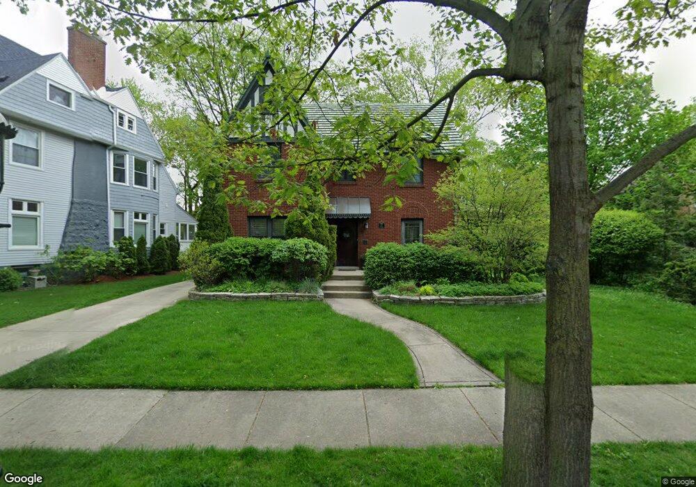
127 Akenside Rd Riverside, IL 60546
Estimated Value: $636,231 - $904,000
3
Beds
2
Baths
2,255
Sq Ft
$327/Sq Ft
Est. Value
About This Home
This home is located at 127 Akenside Rd, Riverside, IL 60546 and is currently estimated at $736,308, approximately $326 per square foot. 127 Akenside Rd is a home located in Cook County with nearby schools including Central Elementary School, L J Hauser Jr High School, and Riverside Brookfield High School.
Ownership History
Date
Name
Owned For
Owner Type
Purchase Details
Closed on
Mar 23, 2001
Sold by
Devaris Peter and Devaris Heather Lynn
Bought by
Giannini Guy and Giannini Elizabeth
Current Estimated Value
Home Financials for this Owner
Home Financials are based on the most recent Mortgage that was taken out on this home.
Original Mortgage
$240,000
Outstanding Balance
$84,169
Interest Rate
7.03%
Estimated Equity
$652,139
Purchase Details
Closed on
Mar 4, 1994
Sold by
Devaris Jerry and Devaris Joyce
Bought by
Devaris Jerry
Create a Home Valuation Report for This Property
The Home Valuation Report is an in-depth analysis detailing your home's value as well as a comparison with similar homes in the area
Home Values in the Area
Average Home Value in this Area
Purchase History
| Date | Buyer | Sale Price | Title Company |
|---|---|---|---|
| Giannini Guy | $442,500 | -- | |
| Devaris Peter | $245,000 | -- | |
| Devaris Jerry | -- | -- |
Source: Public Records
Mortgage History
| Date | Status | Borrower | Loan Amount |
|---|---|---|---|
| Open | Giannini Guy | $240,000 |
Source: Public Records
Tax History
| Year | Tax Paid | Tax Assessment Tax Assessment Total Assessment is a certain percentage of the fair market value that is determined by local assessors to be the total taxable value of land and additions on the property. | Land | Improvement |
|---|---|---|---|---|
| 2025 | $13,800 | $49,105 | $7,275 | $41,830 |
| 2024 | $13,800 | $49,105 | $7,275 | $41,830 |
| 2023 | $10,031 | $49,105 | $7,275 | $41,830 |
| 2022 | $10,031 | $32,344 | $6,283 | $26,061 |
| 2021 | $9,698 | $32,344 | $6,283 | $26,061 |
| 2020 | $9,526 | $32,344 | $6,283 | $26,061 |
| 2019 | $12,187 | $38,056 | $5,787 | $32,269 |
| 2018 | $11,827 | $38,056 | $5,787 | $32,269 |
| 2017 | $11,464 | $38,056 | $5,787 | $32,269 |
| 2016 | $11,666 | $35,623 | $4,960 | $30,663 |
| 2015 | $11,355 | $35,623 | $4,960 | $30,663 |
| 2014 | $11,179 | $35,623 | $4,960 | $30,663 |
| 2013 | $11,400 | $39,172 | $4,960 | $34,212 |
Source: Public Records
Map
Nearby Homes
- 231 Bartram Rd
- 10 E Burlington St Unit 2C
- 10 E Burlington St Unit 2B
- 220 Maplewood Rd
- 236 Maplewood Rd
- 108 E Burlington St Unit B
- 78 Pine Ave
- 124 Forest Ave
- 305 Desplaines Ave
- 269 Shenstone Rd
- 8117 W 30th St
- 315 Bartram Rd
- 367 Bartram Rd
- 101 Southcote Rd
- 410 Repton Rd
- 176 Riverside Rd
- 369 Addison Rd
- 280 Blackhawk Rd
- 2527 Keystone Ave
- 207 W Quincy St Unit GARD
- 131 Akenside Rd
- 106 Michaux Rd
- 135 Akenside Rd
- 110 Michaux Rd
- 139 Akenside Rd
- 114 Michaux Rd
- 122 Michaux Rd
- 124 Akenside Rd
- 147 Akenside Rd
- 130 Akenside Rd
- 118 Akenside Rd
- 136 Akenside Rd
- 136 Akenside Rd
- 142 Akenside Rd
- 110 Akenside Rd
- 136 Michaux Rd
- 155 Akenside Rd
- 95 Michaux Rd
- 146 Akenside Rd
- 105 Michaux Rd
Your Personal Tour Guide
Ask me questions while you tour the home.