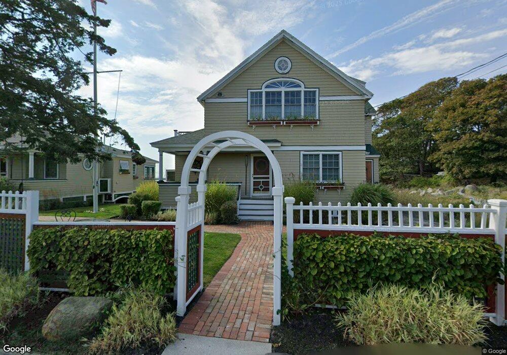
127 Eastern Point Blvd Gloucester, MA 01930
East Gloucester NeighborhoodEstimated Value: $1,775,000 - $2,510,000
2
Beds
1
Bath
985
Sq Ft
$2,161/Sq Ft
Est. Value
About This Home
This home is located at 127 Eastern Point Blvd, Gloucester, MA 01930 and is currently estimated at $2,129,035, approximately $2,161 per square foot. 127 Eastern Point Blvd is a home located in Essex County with nearby schools including East Gloucester Elementary School, Ralph B O'maley Middle School, and Gloucester High School.
Ownership History
Date
Name
Owned For
Owner Type
Purchase Details
Closed on
Jun 16, 2025
Sold by
Daniels Rt and Daniels
Bought by
127-129 Llc
Current Estimated Value
Purchase Details
Closed on
Aug 13, 2009
Sold by
Daniels Arthur A
Bought by
Daniels Jr Tr Arthur A
Purchase Details
Closed on
Sep 17, 1998
Sold by
Brown Dorothy A
Bought by
Daniels Arthur A
Home Financials for this Owner
Home Financials are based on the most recent Mortgage that was taken out on this home.
Original Mortgage
$143,500
Interest Rate
6.9%
Mortgage Type
Purchase Money Mortgage
Create a Home Valuation Report for This Property
The Home Valuation Report is an in-depth analysis detailing your home's value as well as a comparison with similar homes in the area
Home Values in the Area
Average Home Value in this Area
Purchase History
| Date | Buyer | Sale Price | Title Company |
|---|---|---|---|
| 127-129 Llc | -- | None Available | |
| 127-129 Llc | -- | None Available | |
| 127-129 Llc | -- | None Available | |
| Daniels Jr Tr Arthur A | -- | -- | |
| Daniels Jr Tr Arthur A | -- | -- | |
| Daniels Arthur A | $205,000 | -- | |
| Daniels Arthur A | $205,000 | -- |
Source: Public Records
Mortgage History
| Date | Status | Borrower | Loan Amount |
|---|---|---|---|
| Previous Owner | Daniels Arthur A | $560,000 | |
| Previous Owner | Daniels Arthur A | $143,500 |
Source: Public Records
Tax History
| Year | Tax Paid | Tax Assessment Tax Assessment Total Assessment is a certain percentage of the fair market value that is determined by local assessors to be the total taxable value of land and additions on the property. | Land | Improvement |
|---|---|---|---|---|
| 2025 | $15,430 | $1,587,400 | $978,200 | $609,200 |
| 2024 | $14,877 | $1,529,000 | $905,800 | $623,200 |
| 2023 | $13,942 | $1,316,500 | $773,000 | $543,500 |
| 2022 | $13,363 | $1,139,200 | $672,200 | $467,000 |
| 2021 | $12,882 | $1,035,500 | $611,000 | $424,500 |
| 2020 | $12,647 | $1,025,700 | $611,000 | $414,700 |
| 2019 | $11,937 | $940,700 | $582,600 | $358,100 |
| 2018 | $11,426 | $883,700 | $568,300 | $315,400 |
| 2017 | $11,080 | $840,000 | $541,200 | $298,800 |
| 2016 | $10,467 | $769,100 | $517,800 | $251,300 |
| 2015 | $10,071 | $737,800 | $506,100 | $231,700 |
Source: Public Records
Map
Nearby Homes
- 100 Eastern Point Blvd
- 15 Raven Ln Unit 15
- 11 Ocean View Dr
- 1 Wonson St
- 10 Seaview Rd
- 73 Rocky Neck Ave Unit 2
- 60 Rocky Neck Ave Unit 202
- 197 E Main St Unit 1
- 5 Marshfield St
- 33 Middle St
- 35 Middle St Unit 4
- 191 Main St Unit 3
- 191 Main St Unit 2A
- 13 Leslie o Johnson Rd
- 20 Beacon St
- 20 Beacon St Unit 2
- 20 Beacon St Unit 1
- 120 Washington St
- 14R Spring St Unit 3
- 15 Harvard St
- 129 Eastern Point Blvd
- 126 Eastern Point Blvd
- 125 Eastern Point Blvd
- 8 Aileen Terrace
- 5 Aileen Terrace
- 3 Aileen Terrace
- 7 Aileen Terrace
- 117 Eastern Point Blvd
- 135 Eastern Point Blvd
- 114 Eastern Point Blvd
- 2 Rouse Rd
- 27 Fort Hill Ave
- 6 Rouse Rd
- 8 Rouse Rd
- 12 Ramparts Field Rd
- 7 Rouse Rd
- 10 Rouse Rd
- 14 Rouse Rd
- 19 Elm Ave
- 33 Fort Hill Ave
Your Personal Tour Guide
Ask me questions while you tour the home.