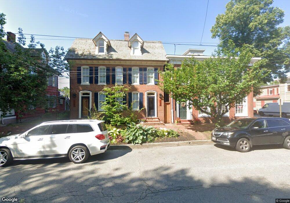
127 High St Chestertown, MD 21620
Estimated Value: $533,050
--
Bed
2
Baths
4,000
Sq Ft
$133/Sq Ft
Est. Value
About This Home
This home is located at 127 High St, Chestertown, MD 21620 and is currently estimated at $533,050, approximately $133 per square foot. 127 High St is a home located in Kent County with nearby schools including Center for Innovation, Kent County Middle School, and Kent County High School.
Ownership History
Date
Name
Owned For
Owner Type
Purchase Details
Closed on
May 31, 2022
Sold by
Bromer Nicholas S
Bought by
Left Bower Llc
Current Estimated Value
Purchase Details
Closed on
Mar 19, 2021
Sold by
Creveling Karen J and Cookerly Richard O
Bought by
Bleuwater Llc
Home Financials for this Owner
Home Financials are based on the most recent Mortgage that was taken out on this home.
Original Mortgage
$350,000
Interest Rate
2.7%
Mortgage Type
Purchase Money Mortgage
Purchase Details
Closed on
Apr 28, 2011
Sold by
Wham Inc
Bought by
Creveling Karen J
Purchase Details
Closed on
Apr 22, 2011
Sold by
Wham Inc
Bought by
Creveling Karen J
Purchase Details
Closed on
Oct 21, 2002
Sold by
Carozza Henrietta and Mary Morrison
Bought by
Wham Inc
Purchase Details
Closed on
Dec 18, 1984
Sold by
Comegys Paul R and Comegys Mary S
Bought by
Carozza Henrietta and Mary Morrison
Create a Home Valuation Report for This Property
The Home Valuation Report is an in-depth analysis detailing your home's value as well as a comparison with similar homes in the area
Home Values in the Area
Average Home Value in this Area
Purchase History
| Date | Buyer | Sale Price | Title Company |
|---|---|---|---|
| Left Bower Llc | $130,000 | Duke Pamela L | |
| Bleuwater Llc | $400,000 | None Available | |
| Creveling Karen J | $470,000 | -- | |
| Creveling Karen J | $470,000 | -- | |
| Wham Inc | $192,000 | -- | |
| Carozza Henrietta | $106,000 | -- |
Source: Public Records
Mortgage History
| Date | Status | Borrower | Loan Amount |
|---|---|---|---|
| Previous Owner | Bleuwater Llc | $350,000 |
Source: Public Records
Tax History Compared to Growth
Tax History
| Year | Tax Paid | Tax Assessment Tax Assessment Total Assessment is a certain percentage of the fair market value that is determined by local assessors to be the total taxable value of land and additions on the property. | Land | Improvement |
|---|---|---|---|---|
| 2025 | $6,012 | $383,600 | $242,100 | $141,500 |
| 2024 | $6,012 | $383,600 | $242,100 | $141,500 |
| 2023 | $7,056 | $450,200 | $242,100 | $208,100 |
| 2022 | $7,011 | $450,200 | $242,100 | $208,100 |
| 2021 | $6,981 | $448,333 | $0 | $0 |
| 2020 | $6,997 | $446,467 | $0 | $0 |
| 2019 | $6,954 | $444,600 | $242,100 | $202,500 |
| 2018 | $6,909 | $444,600 | $242,100 | $202,500 |
| 2017 | $6,687 | $444,600 | $0 | $0 |
| 2016 | -- | $444,600 | $0 | $0 |
| 2015 | $6,791 | $444,600 | $0 | $0 |
| 2014 | $6,791 | $444,600 | $0 | $0 |
Source: Public Records
Map
Nearby Homes
- 105 High St
- 206 Cannon St
- 228 S Water St
- 206 S Water St
- 349 & 351 High St
- 349 High St
- 200 Washington Ave
- 517 High St
- 109 S College Ave
- 234 N College Ave
- 222 Mount Vernon Ave
- 611 Cannon St
- 423 Calvert St
- 303 E Campus Ave
- 0 East St
- 141 Prospect St
- 101 Birch Run Rd
- 118 Little Harbor Way Unit 202
- 36 Landing Ln
- 103 Landing Ln