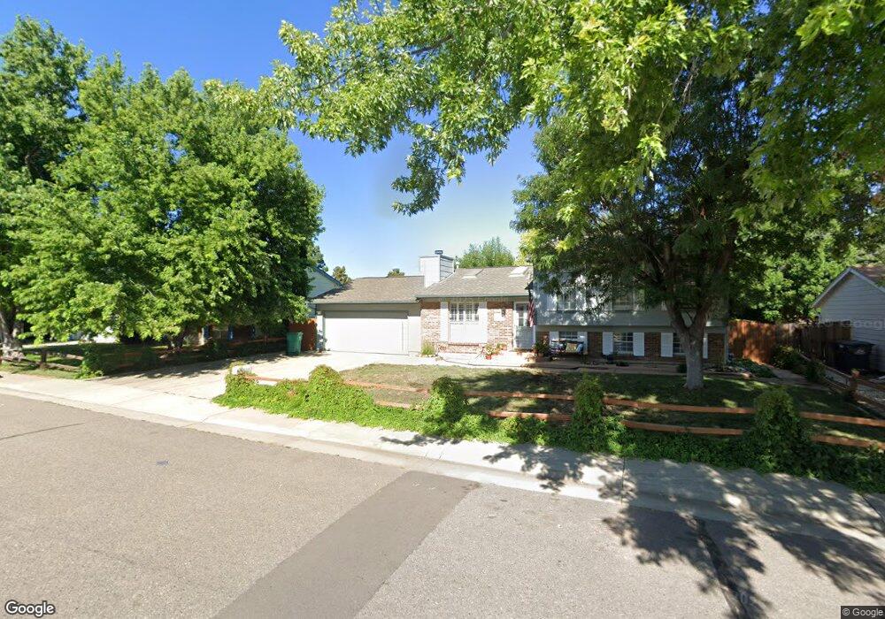
1277 S Memphis St Aurora, CO 80017
Rocky Ridge NeighborhoodEstimated Value: $438,000 - $477,000
3
Beds
3
Baths
1,164
Sq Ft
$392/Sq Ft
Est. Value
About This Home
This home is located at 1277 S Memphis St, Aurora, CO 80017 and is currently estimated at $456,407, approximately $392 per square foot. 1277 S Memphis St is a home located in Arapahoe County with nearby schools including Iowa Elementary School, Mrachek Middle School, and Gateway High School.
Ownership History
Date
Name
Owned For
Owner Type
Purchase Details
Closed on
Jul 28, 2025
Sold by
May Philip S
Bought by
May Frances A
Current Estimated Value
Purchase Details
Closed on
Jul 5, 2000
Sold by
May Phillip S and May Frances E
Bought by
May Philip S and May Frances A
Purchase Details
Closed on
Jan 28, 1997
Sold by
United States Of America
Bought by
May Phillip S and May Frances E
Purchase Details
Closed on
Jun 24, 1992
Sold by
Conversion Arapco
Bought by
May Frances A
Purchase Details
Closed on
Feb 1, 1979
Sold by
Conversion Arapco
Bought by
Conversion Arapco
Purchase Details
Closed on
Jul 4, 1776
Bought by
Conversion Arapco
Create a Home Valuation Report for This Property
The Home Valuation Report is an in-depth analysis detailing your home's value as well as a comparison with similar homes in the area
Home Values in the Area
Average Home Value in this Area
Purchase History
| Date | Buyer | Sale Price | Title Company |
|---|---|---|---|
| May Frances A | -- | None Listed On Document | |
| May Philip S | -- | -- | |
| May Phillip S | -- | -- | |
| May Frances A | -- | -- | |
| Conversion Arapco | -- | -- | |
| Conversion Arapco | -- | -- |
Source: Public Records
Tax History Compared to Growth
Tax History
| Year | Tax Paid | Tax Assessment Tax Assessment Total Assessment is a certain percentage of the fair market value that is determined by local assessors to be the total taxable value of land and additions on the property. | Land | Improvement |
|---|---|---|---|---|
| 2024 | $2,071 | $28,984 | -- | -- |
| 2023 | $2,071 | $28,984 | $0 | $0 |
| 2022 | $1,727 | $24,145 | $0 | $0 |
| 2021 | $1,782 | $24,145 | $0 | $0 |
| 2020 | $1,547 | $22,008 | $0 | $0 |
| 2019 | $1,539 | $22,008 | $0 | $0 |
| 2018 | $1,210 | $18,641 | $0 | $0 |
| 2017 | $1,052 | $18,641 | $0 | $0 |
| 2016 | $686 | $14,607 | $0 | $0 |
| 2015 | $662 | $14,607 | $0 | $0 |
| 2014 | -- | $10,603 | $0 | $0 |
| 2013 | -- | $13,000 | $0 | $0 |
Source: Public Records
Map
Nearby Homes
- 16233 E Louisiana Place
- 16325 E Alabama Dr
- 1262 S Olathe Way
- 16506 E Arizona Dr
- 1305 S Laredo Ct
- 16651 E Arizona Place
- 16555 E Arkansas Ave
- 16673 E Louisiana Dr
- 1140 S Kittredge St
- 16333 E Carolina Dr
- 16634 E Louisiana Dr
- 1462 S Laredo Way
- 15810 E Arkansas Dr
- 16602 E Gunnison Place
- 1409 S Joplin St
- 1191 S Joplin St
- 1024 S Mobile St
- 16975 E Arkansas Ave
- 16133 E Iowa Ave
- 1534 S Ouray Cir Unit B
- 1257 S Memphis St
- 1297 S Memphis St
- 1276 S Lewiston Way
- 1296 S Lewiston Way
- 1256 S Lewiston Way
- 1308 S Lewiston Way
- 1278 S Memphis St
- 1309 S Memphis St
- 1298 S Memphis St
- 1236 S Lewiston Way
- 1238 S Memphis St
- 1318 S Lewiston Way
- 1359 S Memphis St
- 1206 S Lewiston Way
- 1275 S Lewiston Way
- 1295 S Lewiston Way
- 16367 E Wyoming Dr
- 1255 S Lewiston Way
- 1208 S Memphis St
- 1307 S Lewiston Way