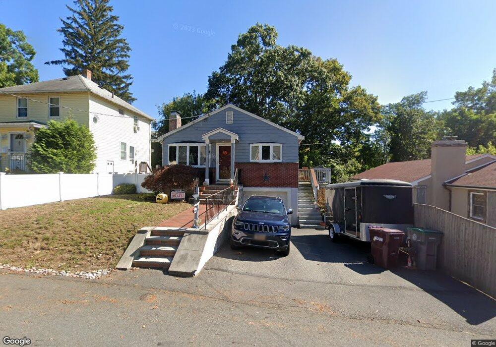
128 Massachusetts Ave Dedham, MA 02026
Riverdale NeighborhoodEstimated Value: $613,000 - $699,000
3
Beds
3
Baths
1,075
Sq Ft
$607/Sq Ft
Est. Value
About This Home
This home is located at 128 Massachusetts Ave, Dedham, MA 02026 and is currently estimated at $652,046, approximately $606 per square foot. 128 Massachusetts Ave is a home located in Norfolk County with nearby schools including Riverdale Elementary School, Dedham Middle School, and Dedham High School.
Ownership History
Date
Name
Owned For
Owner Type
Purchase Details
Closed on
Oct 29, 2008
Sold by
Perosino Beverly R and Perosino Steven M
Bought by
Perosino Steven M
Current Estimated Value
Purchase Details
Closed on
Aug 31, 1994
Sold by
Desai Dipak and Desai Deepak
Bought by
Perosino Steven M and Perosino Beverly R
Purchase Details
Closed on
Dec 30, 1988
Sold by
Taylor Odis
Bought by
Desai Jyoti
Create a Home Valuation Report for This Property
The Home Valuation Report is an in-depth analysis detailing your home's value as well as a comparison with similar homes in the area
Home Values in the Area
Average Home Value in this Area
Purchase History
We collect this data history from publicly available records. To have your information removed, we recommend requesting removal directly through your county’s website.
| Date | Buyer | Sale Price | Title Company |
|---|---|---|---|
| Perosino Steven M | -- | -- | |
| Perosino Steven M | $140,000 | -- | |
| Desai Jyoti | $162,000 | -- |
Source: Public Records
Mortgage History
We collect this data history from publicly available records. To have your information removed, we recommend requesting removal directly through your county’s website.
| Date | Status | Borrower | Loan Amount |
|---|---|---|---|
| Open | Desai Jyoti | $12,000 | |
| Open | Desai Jyoti | $245,000 | |
| Previous Owner | Desai Jyoti | $20,000 |
Source: Public Records
Tax History
| Year | Tax Paid | Tax Assessment Tax Assessment Total Assessment is a certain percentage of the fair market value that is determined by local assessors to be the total taxable value of land and additions on the property. | Land | Improvement |
|---|---|---|---|---|
| 2025 | $6,968 | $552,100 | $307,200 | $244,900 |
| 2024 | $6,630 | $530,400 | $278,700 | $251,700 |
| 2023 | $6,254 | $487,100 | $252,400 | $234,700 |
| 2022 | $5,914 | $443,000 | $237,000 | $206,000 |
| 2021 | $5,621 | $411,200 | $219,500 | $191,700 |
| 2020 | $5,495 | $400,500 | $219,400 | $181,100 |
| 2019 | $5,255 | $371,400 | $190,800 | $180,600 |
| 2018 | $4,924 | $338,400 | $170,600 | $167,800 |
| 2017 | $4,829 | $327,200 | $159,400 | $167,800 |
| 2016 | $4,921 | $317,700 | $147,500 | $170,200 |
| 2015 | $4,582 | $288,700 | $135,900 | $152,800 |
| 2014 | $4,361 | $271,200 | $133,400 | $137,800 |
Source: Public Records
Map
Nearby Homes
- 9 Commonwealth Ave
- 56 Riverview St
- 72 Stivaletta Dr
- 20 Riverview St
- 37 Violet Ave
- 8 Breede Terrace
- 82 Needham St
- 1 Juniper Terrace
- 50 Hillside Rd
- 1515 Vfw Pkwy Unit M19
- 27 Pine St
- 225 Riverside Dr
- 67 Billings St
- 19 New Haven St
- 17-31 Charles Park Rd Unit 196
- 196 Gardner St Unit 196
- 147 Glenellen Rd
- 113 Ames St
- 33 Paragon Rd
- 66 Wycliff Ave Unit 1
- 124 Massachusetts Ave
- 132 Massachusetts Ave
- 17 Commonwealth Ave
- 120 Massachusetts Ave
- 15 Commonwealth Ave
- 138 Massachusetts Ave
- 21 Commonwealth Ave
- 123 Massachusetts Ave
- 131 Massachusetts Ave
- 23 Commonwealth Ave
- 7 Commonwealth Ave
- 115 Massachusetts Ave
- 12 Commonwealth Ave
- 27 Commonwealth Ave
- 29 Commonwealth Ave
- 61 Volk Rd
- 111 Massachusetts Ave
- 60 Egan Terrace
- 58 Volk Rd
- 26 Commonwealth Ave
Your Personal Tour Guide
Ask me questions while you tour the home.