Estimated Value: $884,000 - $1,038,000
2
Beds
1
Bath
1,158
Sq Ft
$827/Sq Ft
Est. Value
About This Home
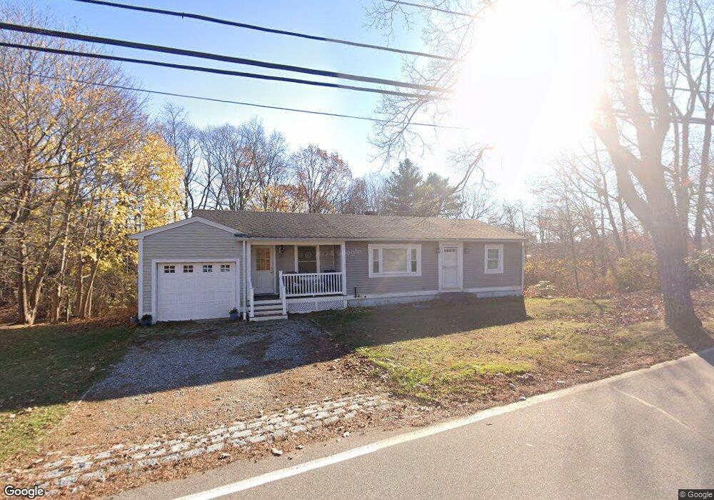
This home is located at 128 Parsons Rd, Rye, NH 03870 and is currently estimated at $958,171, approximately $827 per square foot. 128 Parsons Rd is a home located in Rockingham County with nearby schools including Rye Elementary School, Rye Junior High School, and St Patrick School.
Ownership History
Date
Name
Owned For
Owner Type
Purchase Details
Closed on
Dec 1, 2014
Sold by
Rye Town Of
Bought by
Platt Loretta S
Current Estimated Value
Purchase Details
Closed on
Jan 4, 2010
Sold by
Littlefield Jason P
Bought by
Platt Loretta S
Home Financials for this Owner
Home Financials are based on the most recent Mortgage that was taken out on this home.
Original Mortgage
$220,000
Interest Rate
4.85%
Mortgage Type
Purchase Money Mortgage
Purchase Details
Closed on
May 20, 2004
Sold by
Tyminski Michelle M
Bought by
Littlefield Jason P
Purchase Details
Closed on
Apr 30, 1997
Sold by
Reed Richard O and Reed Sandra L
Bought by
Flynn Brendan M
Create a Home Valuation Report for This Property
The Home Valuation Report is an in-depth analysis detailing your home's value as well as a comparison with similar homes in the area
Home Values in the Area
Average Home Value in this Area
Purchase History
| Date | Buyer | Sale Price | Title Company |
|---|---|---|---|
| Platt Loretta S | -- | -- | |
| Platt Loretta S | $275,000 | -- | |
| Littlefield Jason P | $320,000 | -- | |
| Flynn Brendan M | $130,000 | -- |
Source: Public Records
Mortgage History
| Date | Status | Borrower | Loan Amount |
|---|---|---|---|
| Previous Owner | Flynn Brendan M | $213,000 | |
| Previous Owner | Flynn Brendan M | $220,000 | |
| Previous Owner | Flynn Brendan M | $321,600 |
Source: Public Records
Tax History Compared to Growth
Tax History
| Year | Tax Paid | Tax Assessment Tax Assessment Total Assessment is a certain percentage of the fair market value that is determined by local assessors to be the total taxable value of land and additions on the property. | Land | Improvement |
|---|---|---|---|---|
| 2024 | $5,637 | $650,900 | $478,400 | $172,500 |
| 2023 | $5,227 | $650,900 | $478,400 | $172,500 |
| 2022 | $4,543 | $650,900 | $478,400 | $172,500 |
| 2021 | $4,385 | $429,100 | $304,000 | $125,100 |
| 2020 | $4,385 | $429,100 | $304,000 | $125,100 |
| 2019 | $4,385 | $429,100 | $304,000 | $125,100 |
| 2018 | $4,338 | $429,100 | $304,000 | $125,100 |
| 2017 | $4,176 | $413,100 | $304,000 | $109,100 |
| 2016 | $3,668 | $343,400 | $235,400 | $108,000 |
| 2013 | $3,550 | $323,600 | $236,600 | $87,000 |
Source: Public Records
Map
Nearby Homes
- 105 Parsons Rd
- 21 Triton Dr
- 20 Fairhill Ave
- 1193 Ocean Blvd
- 1215 Ocean Blvd Unit 2
- 1215 Ocean Blvd Unit 3
- 1215 Ocean Blvd Unit 6
- 1215 Ocean Blvd Unit 4
- 51 Wallis Rd
- 137 Clark Rd
- 267 Pioneer Rd
- 2 Rands Ln
- 389 Sagamore Rd
- 480 Sagamore Rd
- 14 Sagamore Rd Unit 3
- 4 Sagamore Rd
- 112 Wentworth Rd
- 1191 - 1193 Ocean Blvd
- 1155 Sagamore Ave Unit 2
- 1155 Sagamore Ave Unit 3