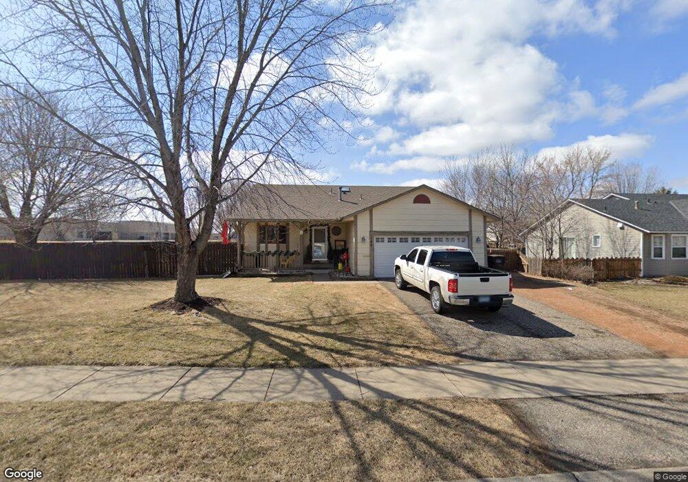
1280 Ruby Ln Shakopee, MN 55379
Estimated Value: $361,139 - $394,000
4
Beds
2
Baths
1,198
Sq Ft
$319/Sq Ft
Est. Value
About This Home
This home is located at 1280 Ruby Ln, Shakopee, MN 55379 and is currently estimated at $382,285, approximately $319 per square foot. 1280 Ruby Ln is a home located in Scott County with nearby schools including Sun Path Elementary School, Shakopee West Middle School, and Shakopee Senior High School.
Ownership History
Date
Name
Owned For
Owner Type
Purchase Details
Closed on
May 25, 2018
Sold by
Loher Jason Robert and Loher Tabatha Ann
Bought by
Hp Minnesota I Llc
Current Estimated Value
Purchase Details
Closed on
Jan 7, 2018
Sold by
Hp Minnesota I Llc
Bought by
Hpa Borrower 2018 1 Ms Llc
Purchase Details
Closed on
Sep 26, 2008
Sold by
Dcs Properties Llc
Bought by
Loher Jason Robert and Loher Tabatha Ann
Purchase Details
Closed on
Oct 12, 2006
Sold by
Swenson Thomas P and Swenson Lori K
Bought by
Dcs Properties Llc
Purchase Details
Closed on
May 9, 1996
Sold by
Hud
Bought by
Swenson Thomas P and Swenson Lori K
Create a Home Valuation Report for This Property
The Home Valuation Report is an in-depth analysis detailing your home's value as well as a comparison with similar homes in the area
Home Values in the Area
Average Home Value in this Area
Purchase History
| Date | Buyer | Sale Price | Title Company |
|---|---|---|---|
| Hp Minnesota I Llc | $303,000 | Burnet Title | |
| Hpa Borrower 2018 1 Ms Llc | $50,000 | Stewart Title Company | |
| Loher Jason Robert | $218,338 | -- | |
| Dcs Properties Llc | $248,000 | -- | |
| Swenson Thomas P | $106,000 | -- |
Source: Public Records
Tax History
| Year | Tax Paid | Tax Assessment Tax Assessment Total Assessment is a certain percentage of the fair market value that is determined by local assessors to be the total taxable value of land and additions on the property. | Land | Improvement |
|---|---|---|---|---|
| 2025 | $3,648 | $345,000 | $161,300 | $183,700 |
| 2024 | $3,800 | $346,100 | $161,300 | $184,800 |
| 2023 | $4,042 | $355,200 | $158,100 | $197,100 |
| 2022 | $3,874 | $371,800 | $158,100 | $213,700 |
| 2021 | $3,414 | $305,100 | $124,000 | $181,100 |
| 2020 | $3,662 | $293,400 | $111,200 | $182,200 |
| 2019 | $3,304 | $276,400 | $93,200 | $183,200 |
| 2018 | $3,082 | $0 | $0 | $0 |
| 2016 | $3,036 | $0 | $0 | $0 |
| 2014 | -- | $0 | $0 | $0 |
Source: Public Records
Map
Nearby Homes
- 1928 Vierling Dr E
- 2027 Brittany Ct
- 2039 Brittany Ct
- 1944 Davis Ct
- 1819 Mockingbird Ave
- 1076 Sibley St S
- 1820 Mockingbird Ave
- 2066 Mockingbird Ave
- 1596 Chartreux Ave
- 2574 Vierling Dr E
- 951 Swift St S
- 2375 Tyrone Dr
- 2423 Tyrone Dr
- 2447 Tyrone Dr
- 1646 Chadum Ln
- 1724 Weston Ln Unit 84
- 1227 Elmwood Ave Unit 85
- 2006 Tyrone Dr
- 1035 Providence Dr
- 1022 Providence Dr
- 1272 Ruby Ln
- 1295 Miller St S
- 1264 Ruby Ln
- 1285 Miller St S
- 1269 Ruby Ln
- 1259 Ruby Ln
- 1275 Miller St S
- 1249 Ruby Ln
- 1256 Ruby Ln
- 1265 Miller St S
- 1852 Vierling Dr E
- 1860 Vierling Dr E
- 1808 Ruby Cir
- 1864 Vierling Dr E
- 1248 Ruby Ln
- 1804 Ruby Cir
- 1868 Vierling Dr E
- 1255 Miller St S
- 1872 Vierling Dr E
- 1292 Miller St S
Your Personal Tour Guide
Ask me questions while you tour the home.