
12814 Pelzel Rd Pilot Point, TX 76258
Estimated payment $203,403/month
Highlights
- 427.5 Acre Lot
- Greenbelt
- Back Yard
- Partially Wooded Lot
- Partially Fenced Property
About This Lot
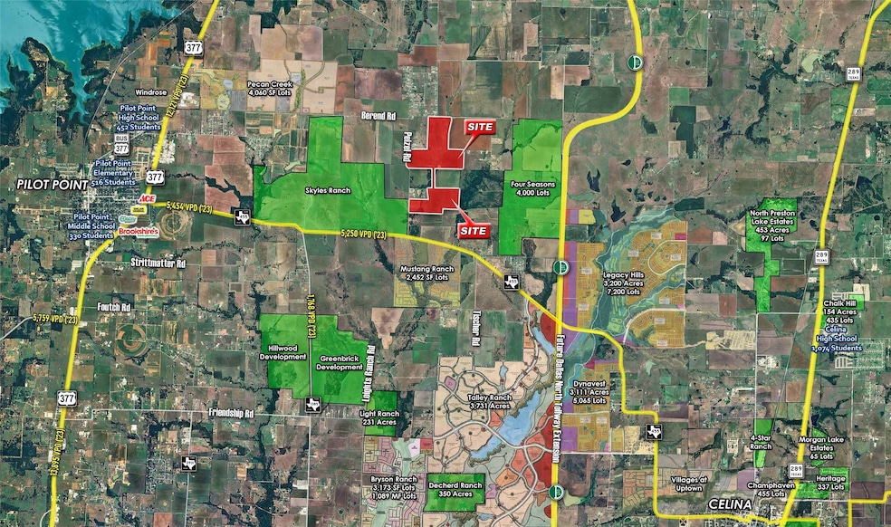
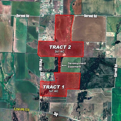
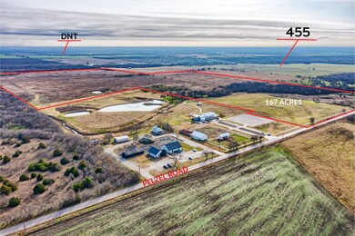
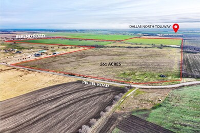
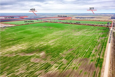
427.5 acres located 1.5 miles West of the Dallas North Tollway and less than half a mile North of FM-455. The property is centrally located in the rapid growth corridor between Pilot Point and Celina, within a five-mile radius of over 17,700 proposed residential lots. The subject property consists of two tracts; Tract 1 totals 166.7 acres with 1,503 feet of frontage on Pelzel Road and Tract 2 which totals 200.3 acres with 1,248 feet of frontage on Pelzel Road and 1,615 feet of frontage on Berend Road. The two tracts are connected via a development easement for roads and utilities. Both tracts are outside the city limits of Pilot Point and fall within the boundaries of Pilot Point ISD. Current Denton County thoroughfare plan shows both Pelzel and Berend Road planned as a major arterial roadway with 4 lanes.
Listing Agent
Talley and Company, LTD Brokerage Phone: 254-718-6791 License #0724414
Property Details
Property Type
- Land
Est. Annual Taxes
- $80
Year Built
- 2003
Lot Details
- 427.5 Acre Lot
- Property fronts a county road
- Partially Fenced Property
- Barbed Wire
- Cleared Lot
- Partially Wooded Lot
- Few Trees
- Back Yard
- Zoning described as Not Zoned
Schools
- Pilot Point Elementary School
- Pilot Point High School
Utilities
- Sewer Not Available
Community Details
- J Curbello Subdivision
- Greenbelt
Listing and Financial Details
- Assessor Parcel Number R40832
Map
Home Values in the Area
Average Home Value in this Area
Tax History
| Year | Tax Paid | Tax Assessment Tax Assessment Total Assessment is a certain percentage of the fair market value that is determined by local assessors to be the total taxable value of land and additions on the property. | Land | Improvement |
|---|---|---|---|---|
| 2024 | $80 | $6,572 | $0 | $0 |
| 2023 | $42,284 | $3,478,015 | $3,478,015 | $0 |
| 2022 | $95 | $6,678 | $6,678 | $0 |
| 2021 | $84 | $5,826 | $5,826 | $0 |
| 2020 | $92 | $6,162 | $6,162 | $0 |
| 2019 | $229 | $14,364 | $14,364 | $0 |
| 2018 | $792 | $49,240 | $23,929 | $25,311 |
| 2017 | $794 | $49,088 | $23,929 | $25,159 |
| 2016 | $918 | $56,713 | $29,855 | $26,858 |
| 2015 | $950 | $58,334 | $30,455 | $27,879 |
| 2013 | -- | $522,401 | $28,655 | $493,746 |
Property History
| Date | Event | Price | Change | Sq Ft Price |
|---|---|---|---|---|
| 04/29/2025 04/29/25 | For Sale | $36,337,500 | -- | -- |
Purchase History
| Date | Type | Sale Price | Title Company |
|---|---|---|---|
| Warranty Deed | -- | None Available | |
| Warranty Deed | -- | Rtt | |
| Interfamily Deed Transfer | -- | None Available | |
| Vendors Lien | -- | -- |
Mortgage History
| Date | Status | Loan Amount | Loan Type |
|---|---|---|---|
| Previous Owner | $211,000 | Balloon | |
| Previous Owner | $215,000 | Purchase Money Mortgage |
Source: North Texas Real Estate Information Systems (NTREIS)
MLS Number: 20918184
APN: R40832
Disclaimer: Certain information contained herein is derived from information provided by parties other than Homes.com. All information provided is deemed reliable, but is not guaranteed to be accurate and should be independently verified.
![]() Listing information provided in part by the North Texas Real Estate Information Systems, Inc, for personal, non-commercial use by viewers of this site and may not be reproduced or redistributed. All information is deemed reliable but not guaranteed. Copyright © NTREIS 2025. All rights reserved
Listing information provided in part by the North Texas Real Estate Information Systems, Inc, for personal, non-commercial use by viewers of this site and may not be reproduced or redistributed. All information is deemed reliable but not guaranteed. Copyright © NTREIS 2025. All rights reserved
- 16531 Fm 455 E
- 16954 Fm 455
- 0 Berend Rd
- 10815 Hames Rd
- 12669 Fm 1385
- 4028 Moss Rd
- 4020 Moss Rd
- 2709 Palo Pinto Trail
- 4012 Red Bluff St
- 2705 Palo Pinto Trail
- 3821 Caddo Dr
- 3817 Caddo Dr
- 4454 Eagle Mountain Ave
- 2708 Gladewater Rd
- 2300 Berend Rd
- 3617 Ray Roberts Rd
- 3801 Possum Kingdom Ln
- 3716 Possum Kingdom Ct
- 3708 Lavon Dr
- 3712 Possum Kingdom Ct
