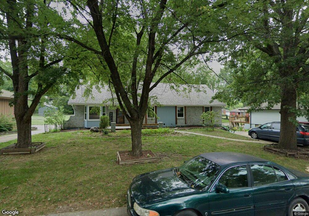
12821 Winchester Ave Grandview, MO 64030
Estimated Value: $241,724 - $308,000
4
Beds
3
Baths
1,040
Sq Ft
$259/Sq Ft
Est. Value
About This Home
This home is located at 12821 Winchester Ave, Grandview, MO 64030 and is currently estimated at $269,681, approximately $259 per square foot. 12821 Winchester Ave is a home located in Jackson County with nearby schools including Conn-West Elementary School, Grandview Middle, and Grandview High School.
Ownership History
Date
Name
Owned For
Owner Type
Purchase Details
Closed on
Dec 28, 2010
Sold by
Nationwide Reo Exchange Inc
Bought by
Franklin Brad and Franklin Lisa
Current Estimated Value
Home Financials for this Owner
Home Financials are based on the most recent Mortgage that was taken out on this home.
Original Mortgage
$100,000
Outstanding Balance
$2,174
Interest Rate
3.79%
Mortgage Type
New Conventional
Estimated Equity
$267,507
Purchase Details
Closed on
Jul 23, 2010
Sold by
Comfort Rita Ann and Reed Elizabeth
Bought by
Nationwide Reo Exchange Inc
Create a Home Valuation Report for This Property
The Home Valuation Report is an in-depth analysis detailing your home's value as well as a comparison with similar homes in the area
Home Values in the Area
Average Home Value in this Area
Purchase History
| Date | Buyer | Sale Price | Title Company |
|---|---|---|---|
| Franklin Brad | -- | None Available | |
| Nationwide Reo Exchange Inc | -- | None Available |
Source: Public Records
Mortgage History
| Date | Status | Borrower | Loan Amount |
|---|---|---|---|
| Open | Franklin Brad | $100,000 |
Source: Public Records
Tax History Compared to Growth
Tax History
| Year | Tax Paid | Tax Assessment Tax Assessment Total Assessment is a certain percentage of the fair market value that is determined by local assessors to be the total taxable value of land and additions on the property. | Land | Improvement |
|---|---|---|---|---|
| 2025 | $309 | $4,104 | $4,001 | $103 |
| 2024 | $2,389 | $3,800 | $3,800 | -- |
| 2023 | $2,389 | $29,886 | $3,107 | $26,779 |
| 2022 | $2,398 | $27,930 | $4,589 | $23,341 |
| 2021 | $2,396 | $27,930 | $4,589 | $23,341 |
| 2020 | $2,152 | $26,575 | $4,589 | $21,986 |
| 2019 | $2,076 | $26,575 | $4,589 | $21,986 |
| 2018 | $1,923 | $22,911 | $3,898 | $19,013 |
| 2017 | $1,923 | $22,911 | $3,898 | $19,013 |
| 2016 | $1,856 | $21,653 | $3,492 | $18,161 |
| 2014 | $1,845 | $21,229 | $3,424 | $17,805 |
Source: Public Records
Map
Nearby Homes
- 12801 Winchester Ave
- 12704 Bristol Ave
- 13008 Corrington Ave
- 12703 Bristol Ave
- 13012 Bristol Ave
- 7201 E 130th Terrace
- 6701 E 127 St
- 12718 Oakland Ave
- 6609 E 129th St
- 6709 E 126th St
- 13006 Byars Rd
- 6600 E 129 St
- 6608 E 128th St
- 12904 Overhill Ave
- 12809 Overhill Ave
- 12217 Bennington Ave
- 12709 Applewood Dr
- 7205 E 131st St
- 12701 Applewood Dr
- 7114 E 132nd St
- 12825 Winchester Ave
- 12817 Winchester Ave
- 12820 Winchester Ave
- 12816 Winchester Ave
- 12813 Winchester Ave
- 12824 Winchester Ave
- 12820 Bristol Ave
- 12812 Winchester Ave
- 12816 Bristol Ave
- 12824 Bristol Ave
- 12901 Winchester Ave
- 12809 Winchester Ave
- 12812 Bristol Ave
- 12808 Winchester Ave
- 7007 E 129th St
- 6908 E 129th St
- 12808 Bristol Ave
- 7011 E 129th St
- 12905 Winchester Ave
- 6904 E 129th St