Estimated Value: $514,000 - $557,000
2
Beds
2
Baths
1,513
Sq Ft
$351/Sq Ft
Est. Value
About This Home
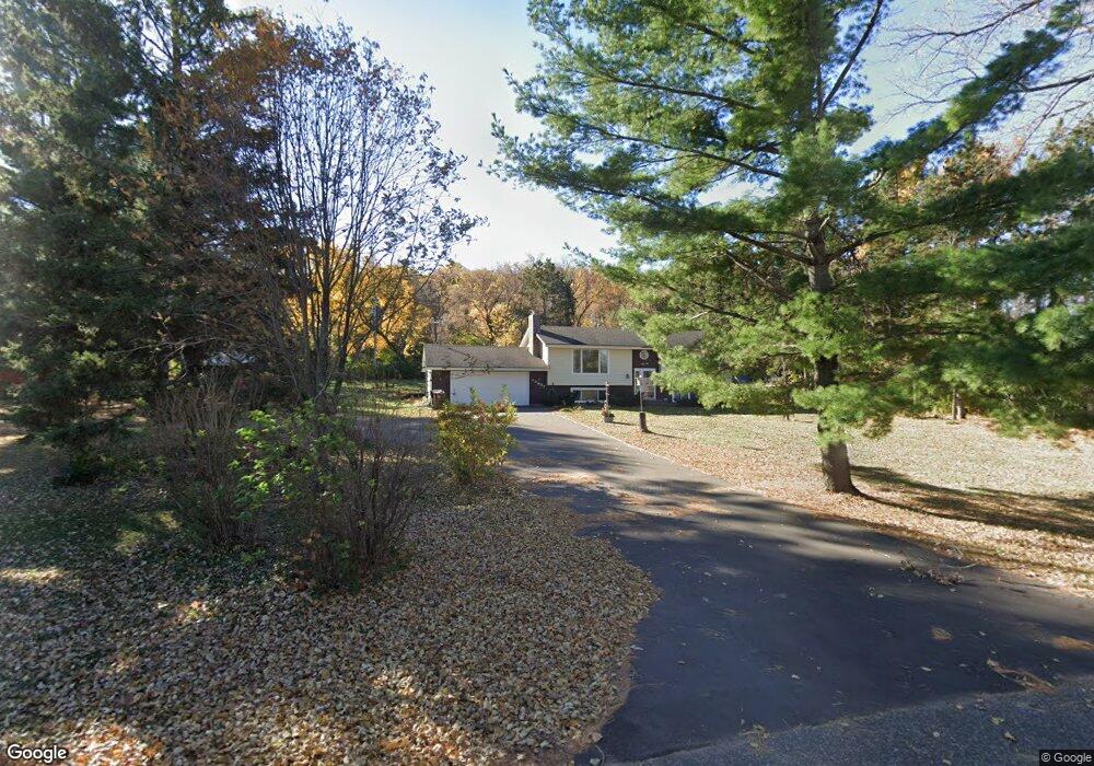
This home is located at 12827 32nd St S, Afton, MN 55001 and is currently estimated at $530,476, approximately $350 per square foot. 12827 32nd St S is a home located in Washington County with nearby schools including Afton-Lakeland Elementary School, Oak-Land Middle School, and Stillwater Area High School.
Ownership History
Date
Name
Owned For
Owner Type
Purchase Details
Closed on
Dec 29, 2021
Sold by
Slitts Jerrold M and Slitts Christine A
Bought by
Slitts Family Trust
Current Estimated Value
Purchase Details
Closed on
Jun 12, 2009
Sold by
Us Bank Na
Bought by
Slitts Jerrold M and Slitts Christine
Home Financials for this Owner
Home Financials are based on the most recent Mortgage that was taken out on this home.
Original Mortgage
$129,500
Interest Rate
5.62%
Mortgage Type
New Conventional
Purchase Details
Closed on
Jul 27, 2004
Sold by
Kahnert Harold C and Kahnert Patricia D
Bought by
Albrightson Kim L
Create a Home Valuation Report for This Property
The Home Valuation Report is an in-depth analysis detailing your home's value as well as a comparison with similar homes in the area
Home Values in the Area
Average Home Value in this Area
Purchase History
| Date | Buyer | Sale Price | Title Company |
|---|---|---|---|
| Slitts Family Trust | $3,000 | Johnson Law Group Pa | |
| Slitts Jerrold M | $185,000 | -- | |
| Albrightson Kim L | $399,500 | -- |
Source: Public Records
Mortgage History
| Date | Status | Borrower | Loan Amount |
|---|---|---|---|
| Previous Owner | Slitts Jerrold M | $129,500 |
Source: Public Records
Tax History Compared to Growth
Tax History
| Year | Tax Paid | Tax Assessment Tax Assessment Total Assessment is a certain percentage of the fair market value that is determined by local assessors to be the total taxable value of land and additions on the property. | Land | Improvement |
|---|---|---|---|---|
| 2024 | $4,388 | $469,700 | $208,800 | $260,900 |
| 2023 | $4,388 | $513,100 | $233,800 | $279,300 |
| 2022 | $3,796 | $445,000 | $194,800 | $250,200 |
| 2021 | $3,556 | $368,400 | $161,100 | $207,300 |
| 2020 | $3,542 | $358,700 | $159,400 | $199,300 |
| 2019 | $3,318 | $361,700 | $159,400 | $202,300 |
| 2018 | $3,190 | $315,700 | $142,900 | $172,800 |
| 2017 | $3,036 | $308,000 | $142,900 | $165,100 |
| 2016 | $3,000 | $290,100 | $142,000 | $148,100 |
| 2015 | $2,746 | $261,300 | $120,200 | $141,100 |
| 2013 | -- | $215,700 | $98,100 | $117,600 |
Source: Public Records
Map
Nearby Homes
- 12403 Meadow Bluff Trail
- 11781 Harvest Path
- 3143 Frontier Dr
- 3181 Frontier Dr
- 14022 E Oakgreen Cir S
- 11568 Ivywood Bay
- 3140 Legacy Ln
- 11333 Ivywood Trail
- 2844 Rosemill Cir
- 11294 Ivywood Trail
- 11344 Eagle View Terrace
- 11309 Harness Draw
- 11458 Balsam Way
- 3015 Arden Dr
- 3452 Mulberry Cir
- 11446 Balsam Way
- 11212 Halstead Trail
- 11080 Dogwood Ct
- 3332 Hazel Trail Unit D
- 3775 Hazel Trail Unit G
- 12885 32nd St S
- 12745 32nd St S
- 12848 32nd St S
- 12991 32nd St S
- 3212 Neal Ave S
- 3170 Neal Ave S
- 3396 Neal Ave S
- 3258 Neal Ave S
- 3110 Neal Ave S
- 12855 30th St S
- 3045 Moyer Ave S
- 3040 Neal Ave S
- XXXX S Neal Ave
- 3181 Neal Ave S
- 12750 30th St S
- 13045 30th St S
- 12595 30th St S
- 12974 30th St S
- 3540 Neal Ave S
- 3475 Neal Ave S