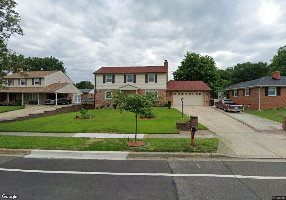
12904 Cambleton Dr Upper Marlboro, MD 20774
Estimated Value: $481,698 - $520,000
4
Beds
3
Baths
--
Sq Ft
9,148
Sq Ft Lot
About This Home
This home is located at 12904 Cambleton Dr, Upper Marlboro, MD 20774 and is currently estimated at $504,925. 12904 Cambleton Dr is a home located in Prince George's County with nearby schools including Perrywood Elementary School, Kettering Middle School, and Largo High School.
Ownership History
Date
Name
Owned For
Owner Type
Purchase Details
Closed on
Aug 17, 2015
Sold by
Gregg Franklin
Bought by
Gregg Franklin and Gregg Lucille
Current Estimated Value
Purchase Details
Closed on
Jul 8, 1997
Sold by
Berkeley Federal Bank & Trust Fsb
Bought by
Gregg Franklin
Purchase Details
Closed on
Apr 1, 1997
Sold by
Jones Barbara W and Stevens Pamela R
Bought by
Berkeley Federal Bank & Trust Fsb
Purchase Details
Closed on
Apr 19, 1983
Sold by
Reuss Robert P
Bought by
Jones Barbara W and Stevens Pamela R
Create a Home Valuation Report for This Property
The Home Valuation Report is an in-depth analysis detailing your home's value as well as a comparison with similar homes in the area
Home Values in the Area
Average Home Value in this Area
Purchase History
| Date | Buyer | Sale Price | Title Company |
|---|---|---|---|
| Gregg Franklin | -- | Attorney | |
| Gregg Franklin | $158,000 | -- | |
| Berkeley Federal Bank & Trust Fsb | $90,000 | -- | |
| Jones Barbara W | $95,500 | -- |
Source: Public Records
Tax History Compared to Growth
Tax History
| Year | Tax Paid | Tax Assessment Tax Assessment Total Assessment is a certain percentage of the fair market value that is determined by local assessors to be the total taxable value of land and additions on the property. | Land | Improvement |
|---|---|---|---|---|
| 2025 | $5,497 | $423,700 | $101,000 | $322,700 |
| 2024 | $5,497 | $406,633 | $0 | $0 |
| 2023 | $5,322 | $389,567 | $0 | $0 |
| 2022 | $5,095 | $372,500 | $101,000 | $271,500 |
| 2021 | $4,838 | $347,833 | $0 | $0 |
| 2020 | $4,691 | $323,167 | $0 | $0 |
| 2019 | $4,517 | $298,500 | $100,500 | $198,000 |
| 2018 | $4,332 | $276,267 | $0 | $0 |
| 2017 | $4,173 | $254,033 | $0 | $0 |
| 2016 | -- | $231,800 | $0 | $0 |
| 2015 | $3,903 | $231,800 | $0 | $0 |
| 2014 | $3,903 | $231,800 | $0 | $0 |
Source: Public Records
Map
Nearby Homes
- 12812 Staton Ct
- 100 Essenton Dr
- 111 Essenton Dr
- 203 Dauntly St
- 126 Weymouth St
- 13108 Keverton Dr
- 13006 Brice Ct
- 13200 Wright Place
- 12916 Fox Bow Dr Unit 107
- 13216 Fox Bow Dr Unit 403
- 13216 Fox Bow Dr Unit 305
- 12900 Fox Bow Dr Unit 206
- 13231 Whiteholm Dr
- 13338 Burleigh St
- 120 Old Enterprise Rd
- 136 Old Enterprise Rd
- 1 Cameron Grove Blvd Unit 301
- 13712 New Acadia Ln
- 13400 Messenger Place
- 83 Watkins Park Dr
- 12906 Cambleton Dr
- 12902 Cambleton Dr
- 12811 Staton Ct
- 12813 Staton Ct
- 12908 Cambleton Dr
- 12900 Cambleton Dr
- 12809 Staton Ct
- 12815 Staton Ct
- 101 Chartsey St
- 100 Chartsey St
- 12903 Cambleton Dr
- 12910 Cambleton Dr
- 12808 Cambleton Dr
- 12807 Staton Ct
- 101 Essenton Dr
- 102 Chartsey St
- 12817 Staton Ct
- 105 Chartsey St
- 100 Cambleton Ct
- 12810 Staton Ct