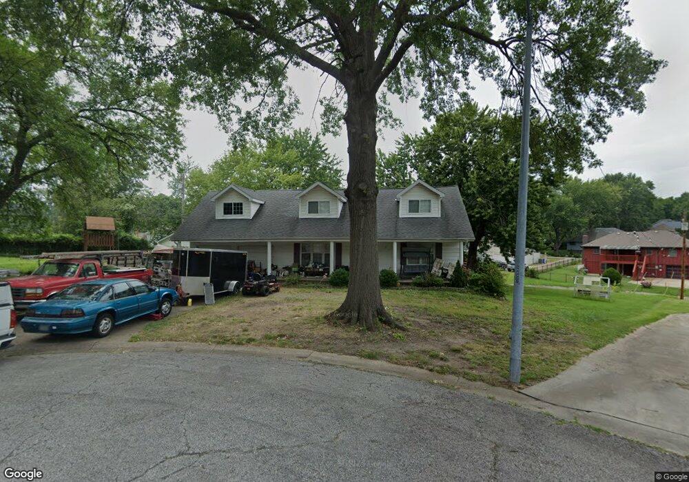
12910 Bristol Ct Grandview, MO 64030
Estimated Value: $244,568 - $286,000
4
Beds
2
Baths
1,498
Sq Ft
$180/Sq Ft
Est. Value
About This Home
This home is located at 12910 Bristol Ct, Grandview, MO 64030 and is currently estimated at $269,142, approximately $179 per square foot. 12910 Bristol Ct is a home located in Jackson County with nearby schools including Conn-West Elementary School, Grandview Middle, and Grandview High School.
Ownership History
Date
Name
Owned For
Owner Type
Purchase Details
Closed on
May 5, 2021
Sold by
Doss Roger and Doss Pam
Bought by
Doss Roger A and Rlt Pamela
Current Estimated Value
Purchase Details
Closed on
Feb 18, 1998
Sold by
Atlantic Mtg & Investment Company
Bought by
Hud
Purchase Details
Closed on
Jan 22, 1998
Sold by
Renwick Sydney M and Kay Sharon
Bought by
Atlantic Mtg & Investment Corp
Create a Home Valuation Report for This Property
The Home Valuation Report is an in-depth analysis detailing your home's value as well as a comparison with similar homes in the area
Home Values in the Area
Average Home Value in this Area
Purchase History
| Date | Buyer | Sale Price | Title Company |
|---|---|---|---|
| Doss Roger A | -- | None Available | |
| Hud | -- | -- | |
| Atlantic Mtg & Investment Corp | $82,504 | -- |
Source: Public Records
Tax History Compared to Growth
Tax History
| Year | Tax Paid | Tax Assessment Tax Assessment Total Assessment is a certain percentage of the fair market value that is determined by local assessors to be the total taxable value of land and additions on the property. | Land | Improvement |
|---|---|---|---|---|
| 2025 | $2,176 | $26,885 | $5,903 | $20,982 |
| 2024 | $2,139 | $26,762 | $4,057 | $22,705 |
| 2023 | $2,139 | $26,762 | $3,538 | $23,224 |
| 2022 | $1,746 | $20,330 | $3,064 | $17,266 |
| 2021 | $1,744 | $20,330 | $3,064 | $17,266 |
| 2020 | $1,571 | $19,398 | $3,064 | $16,334 |
| 2019 | $1,515 | $19,398 | $3,064 | $16,334 |
| 2018 | $1,023,343 | $16,883 | $2,667 | $14,216 |
| 2017 | $1,417 | $16,883 | $2,667 | $14,216 |
| 2016 | $1,270 | $14,816 | $3,772 | $11,044 |
| 2014 | $1,263 | $14,526 | $3,698 | $10,828 |
Source: Public Records
Map
Nearby Homes
- 12801 Winchester Ave
- 13012 Bristol Ave
- 13008 Corrington Ave
- 7201 E 130th Terrace
- 12704 Bristol Ave
- 6609 E 129th St
- 13006 Byars Rd
- 12703 Bristol Ave
- 6600 E 129 St
- 6701 E 127 St
- 12217 Bennington Ave
- 6608 E 128th St
- 6709 E 126th St
- 12718 Oakland Ave
- 7205 E 131st St
- 12904 Overhill Ave
- 7114 E 132nd St
- 13122 Winchester Ave
- 12709 Applewood Dr
- 12809 Overhill Ave
- 12911 Bristol Ct
- 12912 Bristol Ct
- 12915 Bristol Ct
- 7011 E 129th St
- 7105 E 129th St
- 7007 E 129th St
- 12913 Winchester Ave
- 12905 Winchester Ave
- 7109 E 129th St
- 12918 Bristol Ct
- 12919 Winchester Ave
- 12901 Winchester Ave
- 12919 Bristol Ct
- 12914 Corrington Ct
- 7113 E 129th St
- 12910 Corrington Ct
- 12824 Bristol Ave
- 12918 Corrington Ct
- 12825 Bristol Ave
- 7117 E 129th St