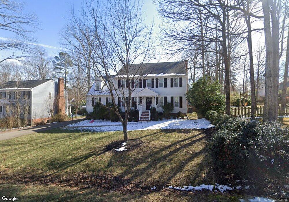
12919 Queensgate Rd Midlothian, VA 23114
Estimated Value: $502,000 - $543,000
4
Beds
3
Baths
2,652
Sq Ft
$199/Sq Ft
Est. Value
About This Home
This home is located at 12919 Queensgate Rd, Midlothian, VA 23114 and is currently estimated at $526,872, approximately $198 per square foot. 12919 Queensgate Rd is a home located in Chesterfield County with nearby schools including J B Watkins Elementary School, Midlothian Middle School, and Midlothian High School.
Ownership History
Date
Name
Owned For
Owner Type
Purchase Details
Closed on
Oct 30, 2019
Sold by
Vlasidis Efstathia
Bought by
Vlasidis James D and Vlasidis Laura E
Current Estimated Value
Home Financials for this Owner
Home Financials are based on the most recent Mortgage that was taken out on this home.
Original Mortgage
$237,000
Outstanding Balance
$208,913
Interest Rate
3.7%
Mortgage Type
New Conventional
Estimated Equity
$317,959
Purchase Details
Closed on
Oct 11, 2000
Bought by
Duval John W
Create a Home Valuation Report for This Property
The Home Valuation Report is an in-depth analysis detailing your home's value as well as a comparison with similar homes in the area
Home Values in the Area
Average Home Value in this Area
Purchase History
| Date | Buyer | Sale Price | Title Company |
|---|---|---|---|
| Vlasidis James D | $325,000 | Attorney | |
| Duval John W | $33,500 | -- |
Source: Public Records
Mortgage History
| Date | Status | Borrower | Loan Amount |
|---|---|---|---|
| Open | Vlasidis James D | $237,000 |
Source: Public Records
Tax History
| Year | Tax Paid | Tax Assessment Tax Assessment Total Assessment is a certain percentage of the fair market value that is determined by local assessors to be the total taxable value of land and additions on the property. | Land | Improvement |
|---|---|---|---|---|
| 2025 | $4,224 | $471,800 | $77,000 | $394,800 |
| 2024 | $4,224 | $457,500 | $72,200 | $385,300 |
| 2023 | $3,850 | $423,100 | $72,200 | $350,900 |
| 2022 | $3,657 | $397,500 | $69,400 | $328,100 |
| 2021 | $3,338 | $344,400 | $67,500 | $276,900 |
| 2020 | $3,230 | $340,000 | $67,500 | $272,500 |
| 2019 | $3,134 | $329,900 | $67,500 | $262,400 |
| 2018 | $3,012 | $314,800 | $64,600 | $250,200 |
| 2017 | $2,984 | $305,600 | $64,600 | $241,000 |
| 2016 | $2,900 | $302,100 | $62,700 | $239,400 |
| 2015 | $2,820 | $291,100 | $60,800 | $230,300 |
| 2014 | $2,785 | $287,500 | $58,900 | $228,600 |
Source: Public Records
Map
Nearby Homes
- 1106 Johanna Bay Dr
- 302 Ashtree Place
- 351 Walton Park Rd
- 13007 Ashtree Rd
- 347 Rossmere Dr
- 12402 Beauridge Ct
- 12409 Avon Lake Cir
- 332 Glenpark Ln
- 13300 Ridgemoor Ln
- 901 Meadowcreek Dr
- 1006 Ashbrook Landing Rd
- 1001 Ashbrook Landing Rd
- 12004 Bromwich Ct
- 1131 Arborway Ln
- 13240 Brattice Loop
- 13232 Brattice Loop
- 13208 Brattice Loop
- 13101 N Brattice Loop
- 13205 Garland Ln
- 13220 Brattice Loop
- 801 Watch Hill Rd
- 12908 Watch Hill Terrace
- 807 Watch Hill Rd
- 12906 Watch Hill Terrace
- 12918 Queensgate Rd
- 12907 Queensgate Rd
- 731 Watch Hill Rd
- 12904 Watch Hill Terrace
- 12912 Queensgate Rd
- 813 Watch Hill Rd
- 725 Watch Hill Rd
- 12902 Watch Hill Terrace
- 724 Shadowhill Ct
- 13001 Queensgate Rd
- 12901 Queensgate Rd
- 12903 Glenshade Dr
- 719 Watch Hill Rd
- 808 Watch Hill Rd
- 13000 Queensgate Rd
- 819 Watch Hill Rd
Your Personal Tour Guide
Ask me questions while you tour the home.