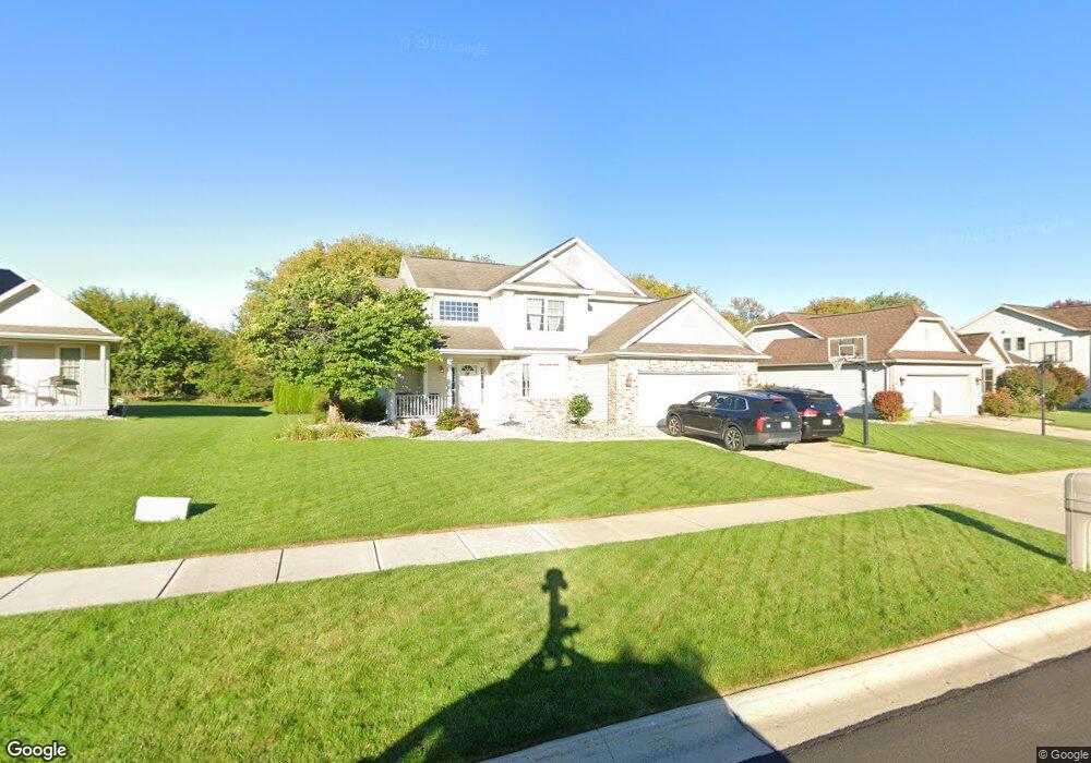
12936 Chartreuse Dr Dewitt, MI 48820
Estimated Value: $397,932 - $508,000
4
Beds
3
Baths
2,188
Sq Ft
$209/Sq Ft
Est. Value
About This Home
This home is located at 12936 Chartreuse Dr, Dewitt, MI 48820 and is currently estimated at $457,733, approximately $209 per square foot. 12936 Chartreuse Dr is a home located in Clinton County with nearby schools including Schavey Road Elementary School, Herbison Woods Elementary School, and Scott Elementary School.
Ownership History
Date
Name
Owned For
Owner Type
Purchase Details
Closed on
Nov 22, 2005
Sold by
Boling Nicole E and Boling Daniel J
Bought by
Dreasky Logan L and Dreasky Sherry A
Current Estimated Value
Home Financials for this Owner
Home Financials are based on the most recent Mortgage that was taken out on this home.
Original Mortgage
$232,750
Outstanding Balance
$128,228
Interest Rate
6.13%
Mortgage Type
Fannie Mae Freddie Mac
Estimated Equity
$329,505
Purchase Details
Closed on
Feb 13, 2004
Sold by
Lakeside Preserve Llc
Bought by
Boling Daniel J and Boling Nicole E
Home Financials for this Owner
Home Financials are based on the most recent Mortgage that was taken out on this home.
Original Mortgage
$170,000
Interest Rate
5.96%
Mortgage Type
Purchase Money Mortgage
Create a Home Valuation Report for This Property
The Home Valuation Report is an in-depth analysis detailing your home's value as well as a comparison with similar homes in the area
Home Values in the Area
Average Home Value in this Area
Purchase History
| Date | Buyer | Sale Price | Title Company |
|---|---|---|---|
| Dreasky Logan L | $245,000 | Bell Title Company | |
| Boling Daniel J | $36,000 | Metropolitan Title Okemos | |
| Lakeside Preserve Llc | -- | Metropolitan Title Company |
Source: Public Records
Mortgage History
| Date | Status | Borrower | Loan Amount |
|---|---|---|---|
| Open | Dreasky Logan L | $232,750 | |
| Previous Owner | Boling Daniel J | $170,000 |
Source: Public Records
Tax History
| Year | Tax Paid | Tax Assessment Tax Assessment Total Assessment is a certain percentage of the fair market value that is determined by local assessors to be the total taxable value of land and additions on the property. | Land | Improvement |
|---|---|---|---|---|
| 2025 | $5,187 | $184,950 | $32,750 | $152,200 |
| 2024 | $15 | $169,350 | $29,700 | $139,650 |
| 2023 | $1,449 | $159,550 | $0 | $0 |
| 2022 | $4,698 | $143,900 | $25,700 | $118,200 |
| 2021 | $4,565 | $139,800 | $25,800 | $114,000 |
| 2020 | $4,283 | $138,100 | $24,400 | $113,700 |
| 2019 | $4,030 | $134,400 | $22,900 | $111,500 |
| 2018 | $3,857 | $123,850 | $21,000 | $102,850 |
| 2017 | $3,804 | $124,250 | $21,400 | $102,850 |
| 2016 | $3,804 | $117,850 | $18,200 | $99,650 |
| 2015 | $3,837 | $106,350 | $0 | $0 |
| 2011 | -- | $112,700 | $0 | $0 |
Source: Public Records
Map
Nearby Homes
- 4083 W Herbison Rd
- 00 Driftwood Dr
- 0 Driftwood Dr
- 12684 Airport Rd
- 4270 Calipso Ct
- 405 Shoreline Dr
- 11740 Kalamata Dr
- 13894 Luroma Cir
- 11625 Murano Dr Unit 63
- 3535 Stanwood Dr
- Integrity 1880 Plan at Shadybrook
- Integrity 1830 Plan at Shadybrook
- Integrity 2080 Plan at Shadybrook
- 2956 Moccasin Dr
- 2969 Moccasin Dr
- 2938 Moccasin Dr
- 2984 Moccasin Dr
- 14013 Ambrosia Ave
- 503 E Geneva Dr
- 4975 W Cutler Rd
- 12930 Chartreuse Dr
- 12938 Chartreuse Dr
- 12900 Chartreuse Dr
- 12940 Chartreuse Dr
- 12935 Chartreuse Dr
- 12925 Chartreuse Dr
- 12945 Chartreuse Dr
- 12860 Chartreuse Dr
- 12905 Chartreuse Dr
- 12944 Chartreuse Dr
- 12865 Chartreuse Dr
- 12946 Chartreuse Dr
- 12940 Paradise Dr
- 12920 Paradise Dr
- 12855 Chartreuse Dr
- 12948 Chartreuse Dr
- 12951 Chartreuse Dr
- 12880 Paradise Dr
- 12950 Chartreuse Dr
Your Personal Tour Guide
Ask me questions while you tour the home.