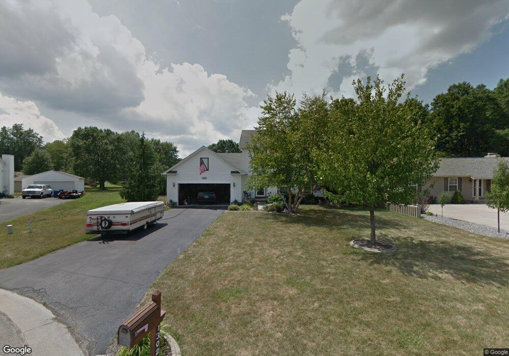
1302 Raspberry Ln Mineral Ridge, OH 44440
Austintown NeighborhoodEstimated Value: $234,000 - $293,759
3
Beds
3
Baths
1,876
Sq Ft
$147/Sq Ft
Est. Value
About This Home
This home is located at 1302 Raspberry Ln, Mineral Ridge, OH 44440 and is currently estimated at $275,440, approximately $146 per square foot. 1302 Raspberry Ln is a home located in Mahoning County with nearby schools including Seaborn Elementary School, Mineral Ridge High School, and Stambaugh Charter Academy.
Ownership History
Date
Name
Owned For
Owner Type
Purchase Details
Closed on
Nov 21, 1996
Sold by
Mount Vernon Estate Ltd
Bought by
Stran Jeffrey J and Stran Jennifer
Current Estimated Value
Home Financials for this Owner
Home Financials are based on the most recent Mortgage that was taken out on this home.
Original Mortgage
$101,650
Interest Rate
7.94%
Mortgage Type
New Conventional
Create a Home Valuation Report for This Property
The Home Valuation Report is an in-depth analysis detailing your home's value as well as a comparison with similar homes in the area
Home Values in the Area
Average Home Value in this Area
Purchase History
| Date | Buyer | Sale Price | Title Company |
|---|---|---|---|
| Stran Jeffrey J | $18,750 | -- |
Source: Public Records
Mortgage History
| Date | Status | Borrower | Loan Amount |
|---|---|---|---|
| Previous Owner | Stran Jeffrey J | $101,650 |
Source: Public Records
Tax History Compared to Growth
Tax History
| Year | Tax Paid | Tax Assessment Tax Assessment Total Assessment is a certain percentage of the fair market value that is determined by local assessors to be the total taxable value of land and additions on the property. | Land | Improvement |
|---|---|---|---|---|
| 2024 | $3,678 | $79,750 | $8,020 | $71,730 |
| 2023 | $3,612 | $79,750 | $8,020 | $71,730 |
| 2022 | $3,341 | $59,170 | $8,020 | $51,150 |
| 2021 | $3,344 | $59,170 | $8,020 | $51,150 |
| 2020 | $3,357 | $59,170 | $8,020 | $51,150 |
| 2019 | $3,309 | $52,890 | $8,020 | $44,870 |
| 2018 | $3,186 | $52,890 | $8,020 | $44,870 |
| 2017 | $3,166 | $52,890 | $8,020 | $44,870 |
| 2016 | $3,100 | $51,260 | $8,020 | $43,240 |
| 2015 | $3,005 | $51,260 | $8,020 | $43,240 |
| 2014 | $3,018 | $51,260 | $8,020 | $43,240 |
| 2013 | $2,984 | $51,260 | $8,020 | $43,240 |
Source: Public Records
Map
Nearby Homes
- 5085 Winslow Dr
- 1239 Woodledge Dr
- 0 W Webb Rd
- 1684 Morris St
- 1467 E County Line Rd
- 1445 E County Line Rd
- 21 E Liberty St
- 3872 Main St
- 3907 Edwards St
- 645 Carlin Dr
- 3579 Bee St
- 2169 Salt Springs Rd
- 3474 S Main St
- 0 W Liberty Unit 5153649
- 6360 Meander Glen Dr
- 6393 Meander Glen Dr
- 4028 Lanterman Rd
- 2555 Walnut St
- 3440 Lakeside Dr
- 4020 Lanterman Rd
- 1310 Raspberry Ln
- 1294 Raspberry Ln
- 1318 Raspberry Ln
- 1286 Raspberry Ln
- 5120 Raspberry Ln
- 5136 Clearfield Dr
- 5119 Raspberry Ln
- 1326 Raspberry Ln
- 5140 Clearfield Dr
- 5128 Clearfield Dr
- 5116 Raspberry Ln
- 1323 Raspberry Ln
- 1305 Cedarwood Dr
- 1311 Cedarwood Dr
- 1299 Cedarwood Dr
- 1334 Raspberry Ln
- 5120 Clearfield Dr
- 1317 Cedarwood Dr
- 1331 Raspberry Ln
- 5112 Raspberry Ln