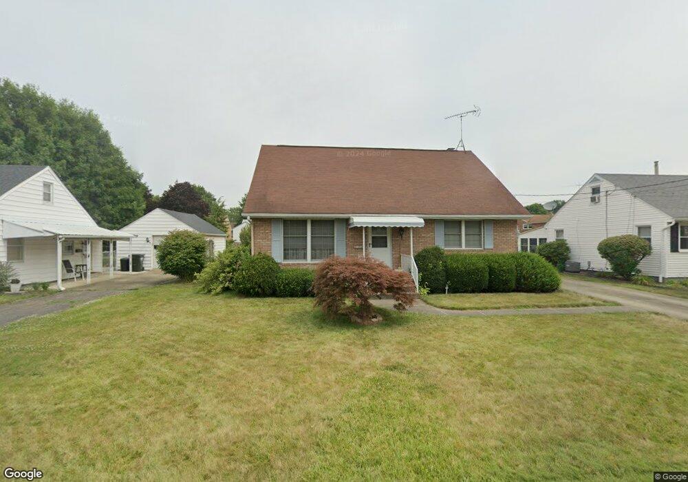
1303 E Broad St Louisville, OH 44641
Estimated Value: $188,586 - $213,000
3
Beds
2
Baths
1,620
Sq Ft
$124/Sq Ft
Est. Value
About This Home
This home is located at 1303 E Broad St, Louisville, OH 44641 and is currently estimated at $200,897, approximately $124 per square foot. 1303 E Broad St is a home located in Stark County with nearby schools including Louisville High School and St. Thomas Aquinas High School & Middle School.
Ownership History
Date
Name
Owned For
Owner Type
Purchase Details
Closed on
Feb 1, 2004
Sold by
Michael Patricia A and Michael Carl W
Bought by
Stevens Richard W and Stevens Nancy B
Current Estimated Value
Home Financials for this Owner
Home Financials are based on the most recent Mortgage that was taken out on this home.
Original Mortgage
$70,000
Interest Rate
5.96%
Mortgage Type
Purchase Money Mortgage
Purchase Details
Closed on
Dec 4, 2002
Sold by
Thomas Dennis J
Bought by
Thomas Patricia A
Purchase Details
Closed on
Aug 21, 2001
Sold by
Conway William G and Conway Grace M
Bought by
Thomas Patricia A
Home Financials for this Owner
Home Financials are based on the most recent Mortgage that was taken out on this home.
Original Mortgage
$96,000
Interest Rate
7.28%
Mortgage Type
Purchase Money Mortgage
Create a Home Valuation Report for This Property
The Home Valuation Report is an in-depth analysis detailing your home's value as well as a comparison with similar homes in the area
Home Values in the Area
Average Home Value in this Area
Purchase History
| Date | Buyer | Sale Price | Title Company |
|---|---|---|---|
| Stevens Richard W | $130,000 | -- | |
| Thomas Patricia A | -- | Bond & Associates Title Agen | |
| Thomas Patricia A | $120,000 | -- |
Source: Public Records
Mortgage History
| Date | Status | Borrower | Loan Amount |
|---|---|---|---|
| Previous Owner | Stevens Richard W | $70,000 | |
| Previous Owner | Thomas Patricia A | $96,000 |
Source: Public Records
Tax History Compared to Growth
Tax History
| Year | Tax Paid | Tax Assessment Tax Assessment Total Assessment is a certain percentage of the fair market value that is determined by local assessors to be the total taxable value of land and additions on the property. | Land | Improvement |
|---|---|---|---|---|
| 2025 | -- | $54,010 | $9,070 | $44,940 |
| 2024 | -- | $54,010 | $9,070 | $44,940 |
| 2023 | $1,663 | $47,850 | $8,580 | $39,270 |
| 2022 | $1,686 | $47,850 | $8,580 | $39,270 |
| 2021 | $1,682 | $47,850 | $8,580 | $39,270 |
| 2020 | $1,361 | $42,920 | $7,740 | $35,180 |
| 2019 | $1,367 | $43,090 | $7,910 | $35,180 |
| 2018 | $1,368 | $43,090 | $7,910 | $35,180 |
| 2017 | $1,210 | $38,050 | $6,970 | $31,080 |
| 2016 | $1,235 | $38,050 | $6,970 | $31,080 |
| 2015 | $1,239 | $38,050 | $6,970 | $31,080 |
| 2014 | $1,099 | $32,900 | $6,020 | $26,880 |
| 2013 | $553 | $32,900 | $6,020 | $26,880 |
Source: Public Records
Map
Nearby Homes
- 308 Superior St
- 641 S Nickelplate St
- 520 S Silver St
- 728 E Broad St
- 1715 High St
- 0 Michigan Blvd
- 1812 E Broad St
- 204 E Broad St
- 107 E Broad St
- 325 Lincoln Ave
- 2015 E Main St
- 2110 Edmar St
- 1170 Winding Ridge Ave
- 908 Sand Lot Cir
- 910 Crosswyck Cir
- 428 Honeycrisp Dr NE
- 3047 Mcintosh Dr NE
- 432 Honeycrisp Dr NE
- 2962 Mcintosh Dr NE
- 2963 Mcintosh Dr NE
- 1223 E Broad St
- 1309 E Broad St
- 1215 E Broad St
- 1306 Monter Ave
- 1300 Monter Ave
- 1312 Monter Ave
- 1220 Monter Ave
- 1300 E Broad St
- 1321 E Broad St
- 1306 E Broad St
- 1216 E Broad St
- 420 S Nickelplate St
- 509 Richards Dr
- 1327 E Broad St
- 1214 Monter Ave
- 1320 Monter Ave
- 426 S Nickelplate St
- 506 S Nickelplate St
- 402 S Nickelplate St
- 0 E Broad St