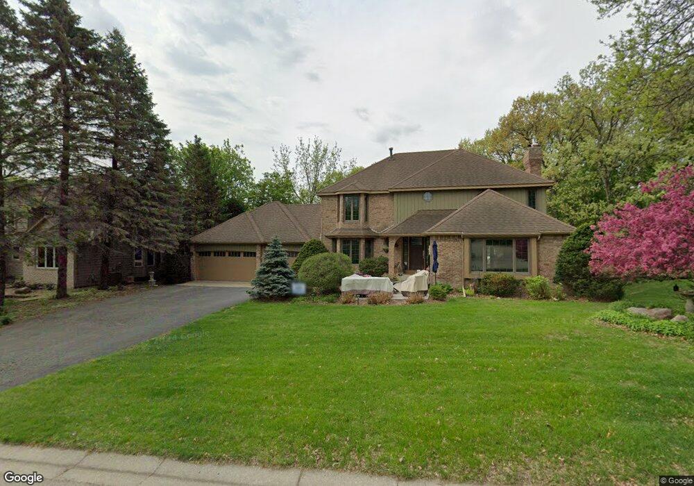
13035 Hialeah Path Saint Paul, MN 55124
Alimagnet NeighborhoodEstimated Value: $560,276 - $629,000
4
Beds
4
Baths
3,840
Sq Ft
$157/Sq Ft
Est. Value
About This Home
This home is located at 13035 Hialeah Path, Saint Paul, MN 55124 and is currently estimated at $601,819, approximately $156 per square foot. 13035 Hialeah Path is a home located in Dakota County with nearby schools including Echo Park Elementary School of Leadership, Engineering & Technology, Falcon Ridge Middle School, and Apple Valley Senior High School.
Ownership History
Date
Name
Owned For
Owner Type
Purchase Details
Closed on
Nov 12, 2010
Sold by
Kauffman Darwin P and Kauffman Teresa L
Bought by
Petter Joseph C and Petter Jody L
Current Estimated Value
Purchase Details
Closed on
Mar 18, 2002
Sold by
Causey Olin H and Causey Sue A
Bought by
Kauffman Darwin P and Kauffman Teresa L
Purchase Details
Closed on
Apr 19, 1909
Sold by
Carlson Keith P and Carlson Carolyn A
Bought by
Causey Olin H and Causey Sue A
Create a Home Valuation Report for This Property
The Home Valuation Report is an in-depth analysis detailing your home's value as well as a comparison with similar homes in the area
Home Values in the Area
Average Home Value in this Area
Purchase History
| Date | Buyer | Sale Price | Title Company |
|---|---|---|---|
| Petter Joseph C | $326,125 | -- | |
| Petter Joseph C | $326,125 | -- | |
| Kauffman Darwin P | $339,000 | -- | |
| Causey Olin H | $288,000 | -- |
Source: Public Records
Tax History
| Year | Tax Paid | Tax Assessment Tax Assessment Total Assessment is a certain percentage of the fair market value that is determined by local assessors to be the total taxable value of land and additions on the property. | Land | Improvement |
|---|---|---|---|---|
| 2024 | $6,114 | $539,800 | $152,600 | $387,200 |
| 2023 | $5,412 | $533,900 | $152,900 | $381,000 |
| 2022 | $5,020 | $508,500 | $152,400 | $356,100 |
| 2021 | $4,868 | $432,500 | $132,500 | $300,000 |
| 2020 | $4,936 | $410,200 | $126,200 | $284,000 |
| 2019 | $4,328 | $403,800 | $120,200 | $283,600 |
| 2018 | $4,412 | $371,800 | $114,500 | $257,300 |
| 2017 | $4,564 | $362,800 | $109,000 | $253,800 |
| 2016 | $4,302 | $356,100 | $103,800 | $252,300 |
| 2015 | $4,547 | $326,275 | $99,595 | $226,680 |
| 2014 | -- | $347,857 | $96,589 | $251,268 |
| 2013 | -- | $332,052 | $88,893 | $243,159 |
Source: Public Records
Map
Nearby Homes
- 13101 Heritage Way
- 104 Belmont Rd
- 13301 Huntington Cir
- 2005 Great Oaks Dr
- 13396 Hughes Ct
- 13590 Hollybrook Dr
- 13001 Pennock Ave Unit Tr 15
- 13598 Hollybrook Dr
- 13732 Hemlock Ct
- 13595 Hollybrook Dr
- 13609 Hollybrook Dr
- 13621 Hollybrook Dr
- 13594 Hollybrook Dr
- 13731 Hollybrook Cir
- 2708 Lassen Ct
- 13731 Hollybrook Dr
- 13751 Hollybrook Cir
- 13751 Hollybrook Dr
- 13763 Hollybrook Dr
- 13761 Hollybrook Cir
- 13037 Hialeah Path
- 13033 Hialeah Path
- 13107 Heritage Way
- 13113 Heritage Way
- 13020 Hershey Way
- 13032 Hialeah Path
- 13119 Heritage Way
- 13108 Palomino Dr
- 13102 Palomino Dr
- 13114 Palomino Dr
- 13031 Hialeah Path
- 13000 Hershey Way
- 12995 Hershey Way
- 13010 Hialeah Path
- 13100 Palomino Dr
- 8299 131st St W
- 13125 Heritage Way
- 13110 Heritage Way
- 13120 Heritage Way
- 8295 131st St W
Your Personal Tour Guide
Ask me questions while you tour the home.