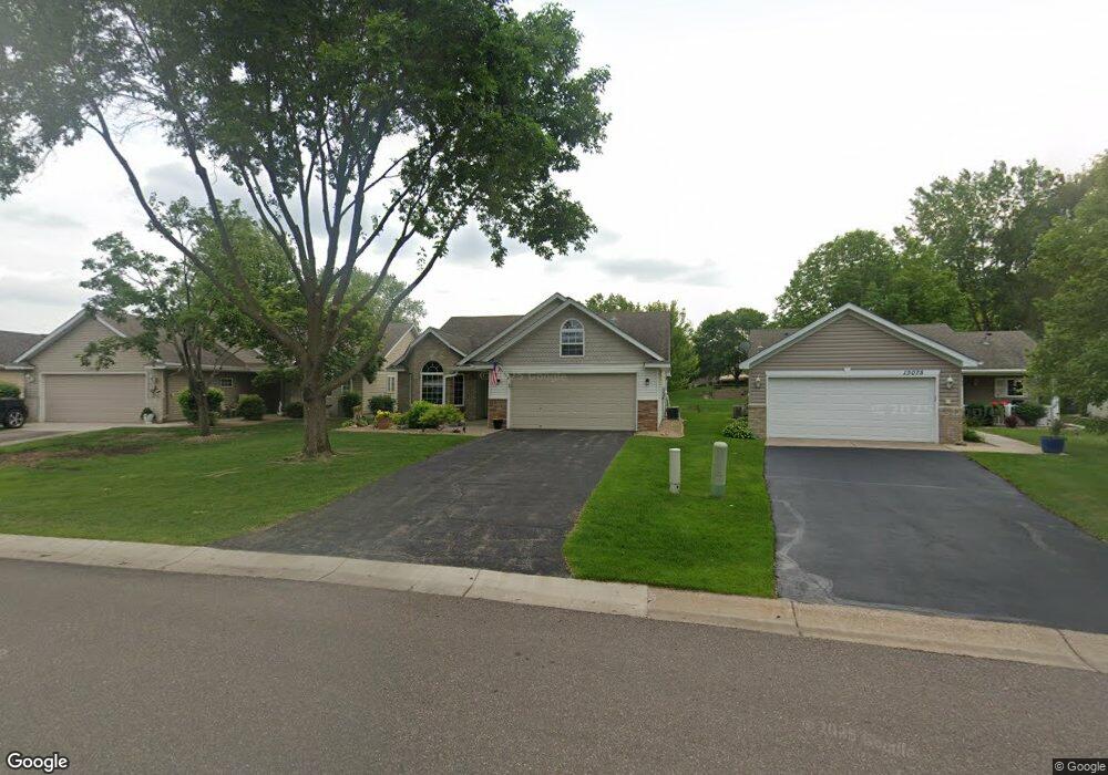
13073 Brookside Ln N Rogers, MN 55374
Estimated Value: $364,000 - $400,035
2
Beds
2
Baths
1,666
Sq Ft
$225/Sq Ft
Est. Value
About This Home
This home is located at 13073 Brookside Ln N, Rogers, MN 55374 and is currently estimated at $375,509, approximately $225 per square foot. 13073 Brookside Ln N is a home located in Hennepin County with nearby schools including Rogers Elementary School, Rogers Middle School, and Rogers Senior High School.
Ownership History
Date
Name
Owned For
Owner Type
Purchase Details
Closed on
May 17, 2022
Sold by
Ulku Phillip D and Ulku Geraldine
Bought by
Ulku Phillip D and Ulku Geraldine
Current Estimated Value
Purchase Details
Closed on
May 4, 2022
Sold by
Nelson Darwin A
Bought by
Ulku Phillip D
Purchase Details
Closed on
Aug 22, 2000
Sold by
Castlebar Homes Llc
Bought by
Nelson Darwin D and Nelson Sharon I
Purchase Details
Closed on
Sep 17, 1999
Sold by
Brook Park Realty Inc
Bought by
Eagle Crest Northwest Inc
Create a Home Valuation Report for This Property
The Home Valuation Report is an in-depth analysis detailing your home's value as well as a comparison with similar homes in the area
Home Values in the Area
Average Home Value in this Area
Purchase History
| Date | Buyer | Sale Price | Title Company |
|---|---|---|---|
| Ulku Phillip D | $400,000 | None Listed On Document | |
| Ulku Phillip D | $400,000 | None Listed On Document | |
| Nelson Darwin D | $175,003 | -- | |
| Castlebar Homes L L C | $28,500 | -- | |
| Eagle Crest Northwest Inc | $26,900 | -- |
Source: Public Records
Tax History Compared to Growth
Tax History
| Year | Tax Paid | Tax Assessment Tax Assessment Total Assessment is a certain percentage of the fair market value that is determined by local assessors to be the total taxable value of land and additions on the property. | Land | Improvement |
|---|---|---|---|---|
| 2024 | $4,725 | $366,900 | $43,000 | $323,900 |
| 2023 | $4,516 | $361,900 | $45,000 | $316,900 |
| 2022 | $3,179 | $278,000 | $27,000 | $251,000 |
| 2021 | $2,840 | $240,000 | $27,000 | $213,000 |
| 2020 | $2,975 | $216,000 | $10,000 | $206,000 |
| 2019 | $2,656 | $215,000 | $10,000 | $205,000 |
| 2018 | $2,177 | $209,000 | $10,000 | $199,000 |
| 2017 | $2,073 | $161,000 | $10,000 | $151,000 |
| 2016 | $2,040 | $156,000 | $20,000 | $136,000 |
| 2015 | $2,265 | $164,000 | $30,000 | $134,000 |
| 2014 | -- | $148,000 | $30,000 | $118,000 |
Source: Public Records
Map
Nearby Homes
- 13053 Brookside Ln N
- 13070 Brookside Ln N
- 13046 Brookside Ln N
- 13019 Brookside Ln N
- 22119 Brenly Way
- 12668 Garden Meadow Ln
- Waverly Plan at Aster Mill - Expressions
- Oakdale Plan at Aster Mill - Inspiration
- Continental Plan at Aster Mill - Expressions
- Mercer Plan at Aster Mill - Expressions
- Mitchell Plan at Aster Mill - Inspiration
- Crisfield Plan at Aster Mill - Inspiration
- Ashton Plan at Aster Mill - Freedom
- Linwood Plan at Aster Mill - Expressions
- Hampton Plan at Aster Mill - Inspiration
- Bowman Plan at Aster Mill - Freedom
- Aspire Plan at Aster Mill - Inspiration
- Duncan Plan at Aster Mill - Freedom
- 12845 Sawyer Ln
- 12841 Sawyer Ln
- 13071 Brookside Ln N
- 13075 Brookside Ln N
- 13069 Brookside Ln N
- 13079 Brookside Ln N
- 13074 Brookside Trail
- 13081 Brookside Ln N
- 13065 Brookside Ln N
- 13076 Brookside Ln N
- 13068 Brookside Ln N
- 13059 Brookside Ln N
- 13080 Brookside Trail
- 13087 Brookside Ln N
- 13068 Brookside Trail
- 13095 Brookside Ln N
- 13096 Brookside Ln N
- 13086 Brookside Trail
- 13078 Brookside Ln N
- 13060 Brookside Ln N
- 13049 Brookside Ln N
- 13052 Brookside Ln N