Estimated Value: $270,000 - $329,000
4
Beds
2
Baths
1,531
Sq Ft
$195/Sq Ft
Est. Value
About This Home
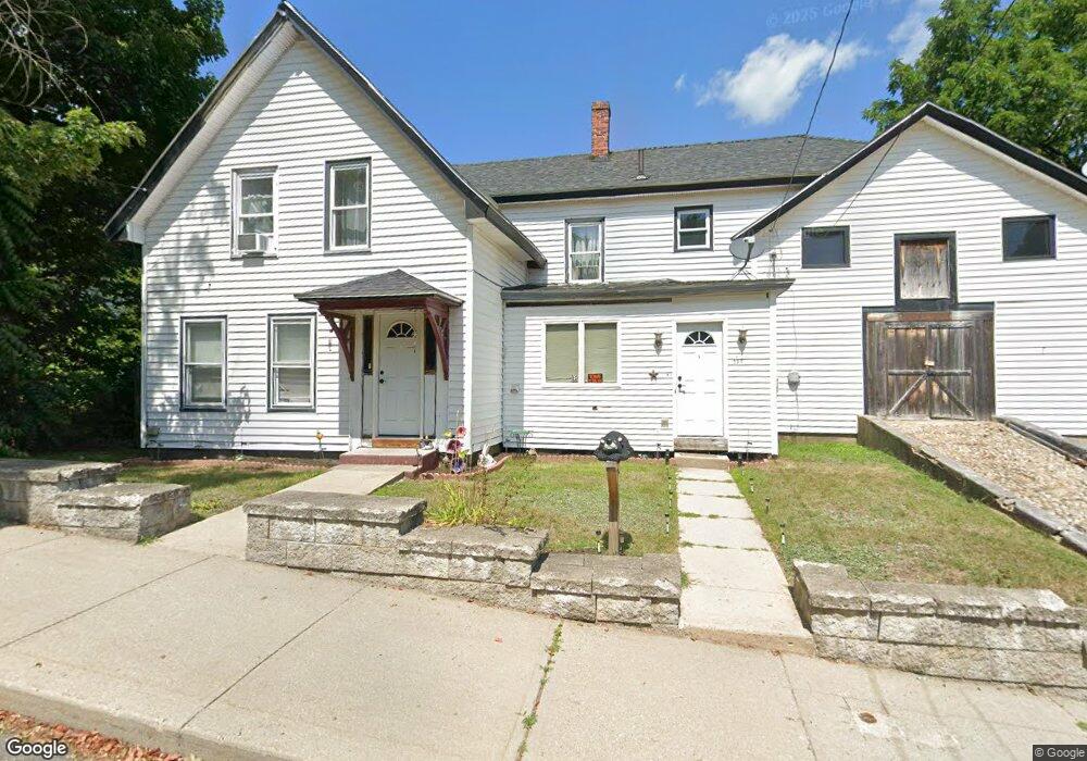
This home is located at 131 Central St, Athol, MA 01331 and is currently estimated at $298,652, approximately $195 per square foot. 131 Central St is a home located in Worcester County with nearby schools including Athol High School.
Ownership History
Date
Name
Owned For
Owner Type
Purchase Details
Closed on
Mar 28, 2019
Sold by
Home Opportunity Llc
Bought by
Colonial Impact Fund 2
Current Estimated Value
Purchase Details
Closed on
Apr 8, 2013
Sold by
Transport Alliance Ban
Bought by
Home Opportunity Llc
Purchase Details
Closed on
Jun 5, 2012
Sold by
Home Solutions Partner
Bought by
Transportation Allianc
Purchase Details
Closed on
Jul 27, 2010
Sold by
Fnma
Bought by
Home Solution Ptnrs 4
Purchase Details
Closed on
Feb 16, 2010
Sold by
Kendall Daniel E
Bought by
Federal National Mortgage Association
Create a Home Valuation Report for This Property
The Home Valuation Report is an in-depth analysis detailing your home's value as well as a comparison with similar homes in the area
Home Values in the Area
Average Home Value in this Area
Purchase History
| Date | Buyer | Sale Price | Title Company |
|---|---|---|---|
| Colonial Impact Fund 2 | -- | -- | |
| Home Opportunity Llc | -- | -- | |
| Transportation Allianc | $19,321 | -- | |
| Home Solution Ptnrs 4 | $26,250 | -- | |
| Federal National Mortgage Association | $107,551 | -- |
Source: Public Records
Tax History
| Year | Tax Paid | Tax Assessment Tax Assessment Total Assessment is a certain percentage of the fair market value that is determined by local assessors to be the total taxable value of land and additions on the property. | Land | Improvement |
|---|---|---|---|---|
| 2025 | $3,101 | $244,000 | $51,600 | $192,400 |
| 2024 | $3,143 | $245,000 | $51,600 | $193,400 |
| 2023 | $3,048 | $217,100 | $37,400 | $179,700 |
| 2022 | $2,911 | $181,400 | $35,600 | $145,800 |
| 2021 | $2,707 | $153,300 | $32,400 | $120,900 |
| 2020 | $2,527 | $147,100 | $29,500 | $117,600 |
| 2019 | $2,405 | $137,800 | $27,900 | $109,900 |
| 2018 | $2,366 | $120,900 | $25,300 | $95,600 |
| 2017 | $2,377 | $116,500 | $25,300 | $91,200 |
| 2016 | $2,165 | $109,200 | $25,300 | $83,900 |
| 2015 | $2,078 | $109,200 | $25,300 | $83,900 |
| 2014 | $2,013 | $109,200 | $25,300 | $83,900 |
Source: Public Records
Map
Nearby Homes
- 105 Central St
- 147 Central St
- 0 Central St
- 87 Central St
- 102 Liberty St
- 132 Central St
- 159 Central St
- 120 Central St
- 107 Park St
- 146 Central St
- 114 Liberty St
- 159 Park St and 102 Central St
- 183 Central St
- 183 Central St Unit 1
- 181 Park St
- 71 Central St
- 64 Liberty St
- 198 High St
- 174 Central St
- 108 Park St
Your Personal Tour Guide
Ask me questions while you tour the home.