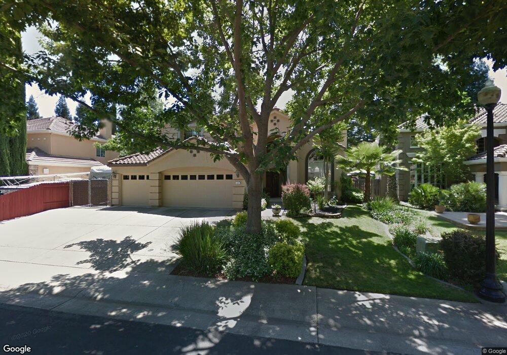
131 Demurrage Way Folsom, CA 95630
Natoma Station NeighborhoodEstimated Value: $685,000 - $907,000
4
Beds
3
Baths
2,534
Sq Ft
$326/Sq Ft
Est. Value
About This Home
This home is located at 131 Demurrage Way, Folsom, CA 95630 and is currently estimated at $825,739, approximately $325 per square foot. 131 Demurrage Way is a home located in Sacramento County with nearby schools including Natoma Station Elementary School, Sutter Middle School, and Folsom High School.
Ownership History
Date
Name
Owned For
Owner Type
Purchase Details
Closed on
Aug 22, 2024
Sold by
Theis James E and Theis Laurie L
Bought by
Theis Family Trust and Theis
Current Estimated Value
Purchase Details
Closed on
Jul 30, 2003
Sold by
Ung Edmund H and Ung Sandra Yu
Bought by
Theis James E and Theis Laurie L
Home Financials for this Owner
Home Financials are based on the most recent Mortgage that was taken out on this home.
Original Mortgage
$315,000
Interest Rate
5.17%
Mortgage Type
Purchase Money Mortgage
Create a Home Valuation Report for This Property
The Home Valuation Report is an in-depth analysis detailing your home's value as well as a comparison with similar homes in the area
Home Values in the Area
Average Home Value in this Area
Purchase History
| Date | Buyer | Sale Price | Title Company |
|---|---|---|---|
| Theis Family Trust | -- | None Listed On Document | |
| Theis James E | $394,000 | Placer Title Company |
Source: Public Records
Mortgage History
| Date | Status | Borrower | Loan Amount |
|---|---|---|---|
| Previous Owner | Theis James E | $315,000 | |
| Closed | Theis James E | $59,000 |
Source: Public Records
Tax History Compared to Growth
Tax History
| Year | Tax Paid | Tax Assessment Tax Assessment Total Assessment is a certain percentage of the fair market value that is determined by local assessors to be the total taxable value of land and additions on the property. | Land | Improvement |
|---|---|---|---|---|
| 2025 | $6,446 | $601,985 | $120,842 | $481,143 |
| 2024 | $6,446 | $590,182 | $118,473 | $471,709 |
| 2023 | $6,332 | $578,610 | $116,150 | $462,460 |
| 2022 | $6,240 | $567,266 | $113,873 | $453,393 |
| 2021 | $6,156 | $556,144 | $111,641 | $444,503 |
| 2020 | $6,080 | $550,443 | $110,497 | $439,946 |
| 2019 | $5,980 | $539,651 | $108,331 | $431,320 |
| 2018 | $6,213 | $529,070 | $106,207 | $422,863 |
| 2017 | $5,849 | $518,697 | $104,125 | $414,572 |
| 2016 | $6,087 | $508,528 | $102,084 | $406,444 |
| 2015 | $6,054 | $500,890 | $100,551 | $400,339 |
| 2014 | $5,778 | $491,079 | $98,582 | $392,497 |
Source: Public Records
Map
Nearby Homes
- 116 Demurrage Way
- 137 John Henry Cir
- 122 Kennar Way
- 98 Demurrage Way
- 179 Orange Blossom Cir Unit C
- 105 Donegan Ct
- 145 Hopfield Dr
- 323 Brightstone Cir
- 916 Blue Rapids Dr
- 1141 Sandy Creek Dr
- 300 Coventry Cir
- 1117 Sandy Creek Dr
- 664 Cole Ct
- 661 Fisher Cir
- 968 Nichols Cir
- 380 Gardner Ct
- 921 Farmhouse Way
- 301 Blossom Rock Ln Unit 53
- 276 Barnhill Dr
- 206 Barnhill Dr
- 129 Demurrage Way
- 133 Demurrage Way
- 156 John Henry Cir
- 152 John Henry Cir
- 160 John Henry Cir
- 127 Demurrage Way
- 166 John Henry Cir
- 164 John Henry Cir
- 124 Demurrage Way
- 148 John Henry Cir
- 128 Demurrage Way
- 162 John Henry Cir
- 168 John Henry Cir
- 125 Demurrage Way
- 144 John Henry Cir
- 120 Demurrage Way
- 170 John Henry Cir
- 123 Demurrage Way
- 140 John Henry Cir
- 153 John Henry Cir