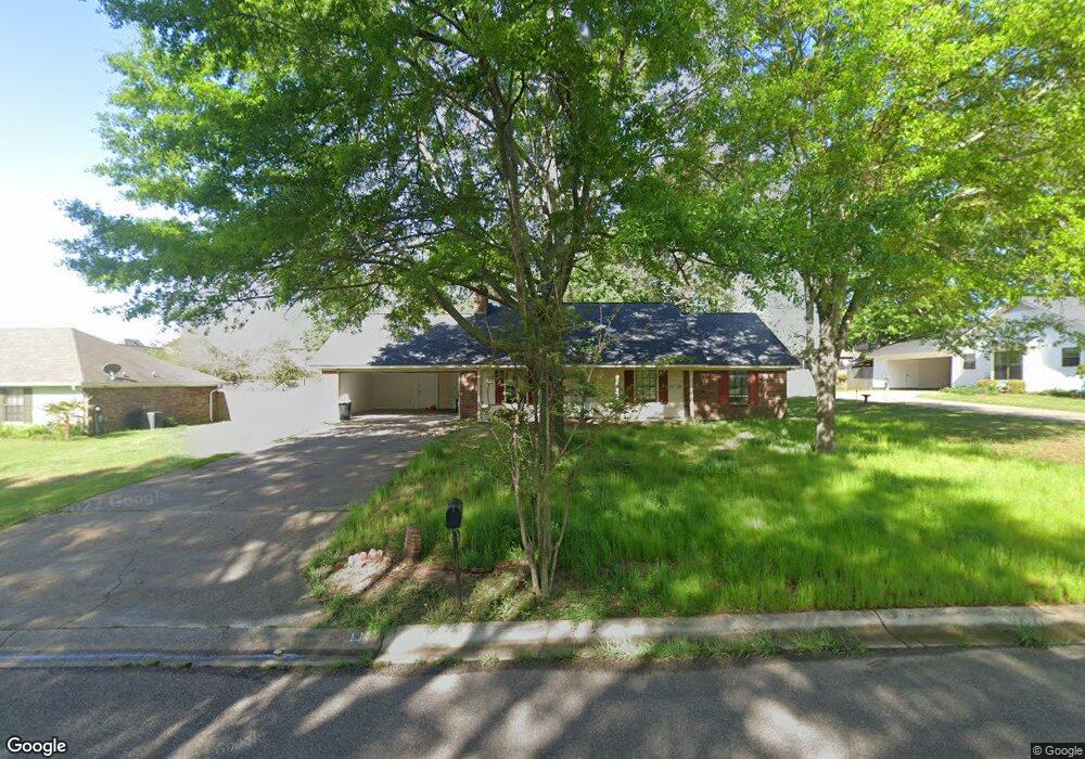
131 Stonegate Dr Madison, MS 39110
Estimated Value: $238,121 - $256,000
3
Beds
2
Baths
1,460
Sq Ft
$168/Sq Ft
Est. Value
About This Home
This home is located at 131 Stonegate Dr, Madison, MS 39110 and is currently estimated at $245,780, approximately $168 per square foot. 131 Stonegate Dr is a home located in Madison County with nearby schools including Madison Avenue Elementary, Madison Avenue Upper Elementary School, and Madison Middle School.
Ownership History
Date
Name
Owned For
Owner Type
Purchase Details
Closed on
Nov 13, 2008
Sold by
Trihoulis George and Trihoulis Jennifer
Bought by
Dixon Gayla
Current Estimated Value
Home Financials for this Owner
Home Financials are based on the most recent Mortgage that was taken out on this home.
Original Mortgage
$3,968
Interest Rate
6.51%
Mortgage Type
Stand Alone Second
Purchase Details
Closed on
Feb 17, 2006
Sold by
Fairley Jessie F Brantley and Brantley Jessie F
Bought by
Thihoulis George and Thihoulis Jennifer
Create a Home Valuation Report for This Property
The Home Valuation Report is an in-depth analysis detailing your home's value as well as a comparison with similar homes in the area
Home Values in the Area
Average Home Value in this Area
Purchase History
| Date | Buyer | Sale Price | Title Company |
|---|---|---|---|
| Dixon Gayla | -- | None Available | |
| Thihoulis George | -- | Abstract & Closing Title Ser |
Source: Public Records
Mortgage History
| Date | Status | Borrower | Loan Amount |
|---|---|---|---|
| Closed | Dixon Gayla | $3,968 |
Source: Public Records
Tax History
| Year | Tax Paid | Tax Assessment Tax Assessment Total Assessment is a certain percentage of the fair market value that is determined by local assessors to be the total taxable value of land and additions on the property. | Land | Improvement |
|---|---|---|---|---|
| 2025 | $1,152 | $12,456 | $0 | $0 |
| 2024 | $1,152 | $12,456 | $0 | $0 |
| 2023 | $1,152 | $12,456 | $0 | $0 |
| 2022 | $1,152 | $12,456 | $0 | $0 |
| 2021 | $1,105 | $12,054 | $0 | $0 |
| 2020 | $1,105 | $12,054 | $0 | $0 |
| 2019 | $1,105 | $12,054 | $0 | $0 |
| 2018 | $1,046 | $11,554 | $0 | $0 |
| 2017 | $1,028 | $11,392 | $0 | $0 |
| 2016 | $1,028 | $11,392 | $0 | $0 |
| 2015 | $1,028 | $11,392 | $0 | $0 |
| 2014 | $1,203 | $12,901 | $0 | $0 |
Source: Public Records
Map
Nearby Homes
- 204 Belle Rose Cir
- 422 Summerville Dr
- 169 Saint Ives Dr
- 105 Victoria Place
- 345 Avonlea Ln
- 220 Vintage Dr
- 290 Geneva Blvd
- 245 Mackey Dr
- 1241 Woodberry Dr
- 1205 Woodberry Dr
- 161 Victoria Place
- 1141 Highway 51
- 00 Saint Augustine Dr
- 0 Saint Augustine Dr
- 112 Brashear St
- 865 Wellington Way
- 000 Mississippi 463
- 6 Eastbrooke Cir
- 112 Woodsong Way
- 1 Eastbrooke Cir
- 133 Stonegate Dr
- 129 Stonegate Dr
- 246 Brisage Blvd
- 246 Brisage Blvd
- 242 Brisage Blvd
- 202 Creekline Dr
- 250 Brisage Blvd
- 238 Brisage Blvd
- 135 Stonegate Dr
- 127 Stonegate Dr
- 254 Brisage Blvd
- 130 Stonegate Dr
- 201 Creekline Dr
- 0 Brisage Blvd Unit Lot 24 1136307
- 0 Brisage Blvd Unit Lot 28 1136306
- 0 Brisage Blvd Unit Lot 4 1140959
- 0 Brisage Blvd Unit lot 41 1143535
- 0 Brisage Blvd Unit Lot 31 1146962
- 0 Brisage Blvd Unit lot 20 1164747
- 0 Brisage Blvd Unit lot 20 1168485
Your Personal Tour Guide
Ask me questions while you tour the home.