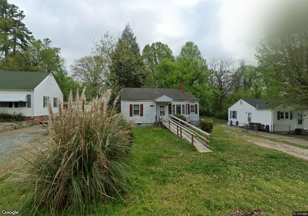
1311 Woodside Dr Greensboro, NC 27405
Rosewood NeighborhoodEstimated Value: $95,000 - $147,000
2
Beds
1
Bath
810
Sq Ft
$150/Sq Ft
Est. Value
About This Home
This home is located at 1311 Woodside Dr, Greensboro, NC 27405 and is currently estimated at $121,457, approximately $149 per square foot. 1311 Woodside Dr is a home located in Guilford County with nearby schools including Irving Park Elementary School, Melvin C. Swann Jr. Middle School, and Page High School.
Ownership History
Date
Name
Owned For
Owner Type
Purchase Details
Closed on
May 15, 2003
Sold by
Ctx Mortgage
Bought by
Davis Fanchon E
Current Estimated Value
Home Financials for this Owner
Home Financials are based on the most recent Mortgage that was taken out on this home.
Original Mortgage
$38,700
Outstanding Balance
$16,783
Interest Rate
5.76%
Mortgage Type
Purchase Money Mortgage
Estimated Equity
$104,674
Purchase Details
Closed on
Aug 8, 2001
Sold by
Hud
Bought by
Ctx Mortgage Co
Purchase Details
Closed on
Mar 1, 2001
Sold by
Ton K and Ka Bep
Bought by
Hud
Purchase Details
Closed on
Aug 31, 1998
Sold by
Lavalley Jennie Maupin and Lavalley Albert C
Bought by
Ton K and Ka Bep
Home Financials for this Owner
Home Financials are based on the most recent Mortgage that was taken out on this home.
Original Mortgage
$48,983
Interest Rate
6.92%
Mortgage Type
FHA
Create a Home Valuation Report for This Property
The Home Valuation Report is an in-depth analysis detailing your home's value as well as a comparison with similar homes in the area
Home Values in the Area
Average Home Value in this Area
Purchase History
| Date | Buyer | Sale Price | Title Company |
|---|---|---|---|
| Davis Fanchon E | $43,000 | -- | |
| Ctx Mortgage Co | -- | -- | |
| Hud | $53,134 | -- | |
| Ton K | $52,000 | -- |
Source: Public Records
Mortgage History
| Date | Status | Borrower | Loan Amount |
|---|---|---|---|
| Open | Davis Fanchon E | $38,700 | |
| Previous Owner | Ton K | $48,983 | |
| Closed | Ton K | $5,000 |
Source: Public Records
Tax History Compared to Growth
Tax History
| Year | Tax Paid | Tax Assessment Tax Assessment Total Assessment is a certain percentage of the fair market value that is determined by local assessors to be the total taxable value of land and additions on the property. | Land | Improvement |
|---|---|---|---|---|
| 2025 | $807 | $57,500 | $16,000 | $41,500 |
| 2024 | $807 | $57,500 | $16,000 | $41,500 |
| 2023 | $807 | $57,500 | $16,000 | $41,500 |
| 2022 | $784 | $57,500 | $16,000 | $41,500 |
| 2021 | $788 | $56,600 | $15,000 | $41,600 |
| 2020 | $788 | $56,600 | $15,000 | $41,600 |
| 2019 | $788 | $56,600 | $0 | $0 |
| 2018 | $766 | $56,600 | $0 | $0 |
| 2017 | $766 | $56,600 | $0 | $0 |
| 2016 | $662 | $47,800 | $0 | $0 |
| 2015 | $666 | $47,800 | $0 | $0 |
| 2014 | $670 | $47,800 | $0 | $0 |
Source: Public Records
Map
Nearby Homes
- 1307 Mayfair Ave
- 1210 Summit Ave
- 1600 N Ohenry Blvd
- 1502 Fairview St
- 1605 Ball St
- 1213 Lolly Ln
- 1517 Tucker St
- 1525 Tucker St
- 1317 Joyce St
- 1719 Phillips Ave
- 1707 Water St
- 1804 Gordon St
- 1612 N English St
- 2202 Textile Dr
- 1703 Buffalo St
- 110 Sunset Cir Unit 102
- 102 Sunset Cir Unit 203
- 100 Sunset Cir Unit 304
- 309 E Bessemer Ave
- 805 N Church St
- 1313 Woodside Dr
- 1309 Woodside Dr
- 1315 Woodside Dr
- 1307 Woodside Dr
- 1817 Gatewood Ave
- 1821 Gatewood Ave
- 1815 Gatewood Ave
- 1823 Gatewood Ave
- 1319 Woodside Dr
- 1825 Gatewood Ave
- 1811 Gatewood Ave
- 1312 Woodside Dr
- 1310 Woodside Dr
- 1314 Woodside Dr
- 1308 Woodside Dr
- 1316 Woodside Dr
- 1402 Summit Ave
- 1809 Gatewood Ave
- 1321 Woodside Dr
- 1306 Woodside Dr