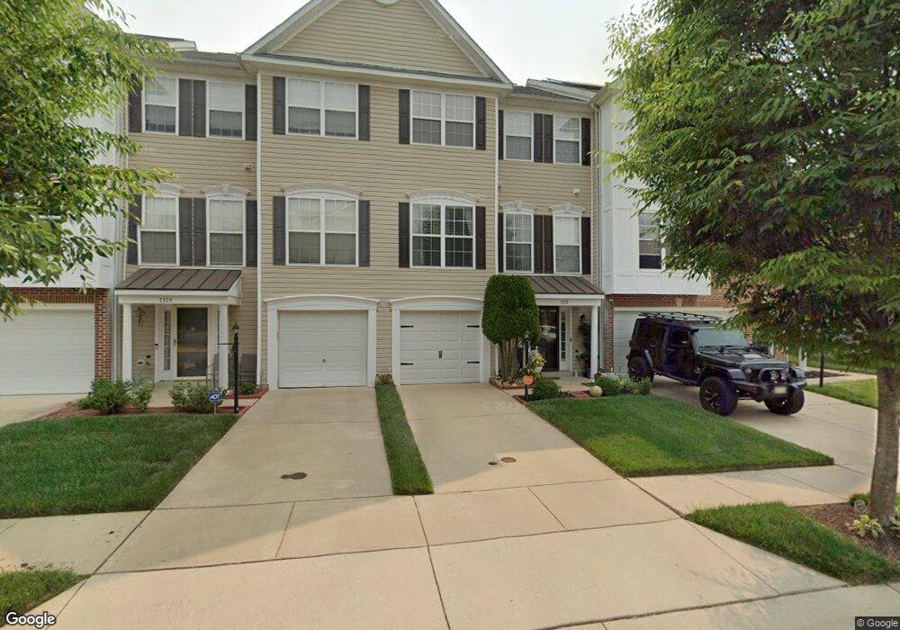
1313 Ring Bill Loop Upper Marlboro, MD 20774
Estimated Value: $468,000 - $495,000
3
Beds
4
Baths
2,400
Sq Ft
$200/Sq Ft
Est. Value
About This Home
This home is located at 1313 Ring Bill Loop, Upper Marlboro, MD 20774 and is currently estimated at $479,027, approximately $199 per square foot. 1313 Ring Bill Loop is a home located in Prince George's County with nearby schools including Perrywood Elementary School, Kettering Middle School, and Largo High School.
Ownership History
Date
Name
Owned For
Owner Type
Purchase Details
Closed on
Mar 31, 2006
Sold by
Miller Ritchie W
Bought by
Livingston Robin D
Current Estimated Value
Home Financials for this Owner
Home Financials are based on the most recent Mortgage that was taken out on this home.
Original Mortgage
$84,000
Interest Rate
6.17%
Mortgage Type
Stand Alone Second
Purchase Details
Closed on
Feb 8, 2006
Sold by
Miller Ritchie W
Bought by
Livingston Robin D
Home Financials for this Owner
Home Financials are based on the most recent Mortgage that was taken out on this home.
Original Mortgage
$84,000
Interest Rate
6.17%
Mortgage Type
Stand Alone Second
Purchase Details
Closed on
Dec 5, 2003
Sold by
Washington Homes Of Maryl& I
Bought by
Miller Ritchie W and Miller Suzette M
Create a Home Valuation Report for This Property
The Home Valuation Report is an in-depth analysis detailing your home's value as well as a comparison with similar homes in the area
Home Values in the Area
Average Home Value in this Area
Purchase History
| Date | Buyer | Sale Price | Title Company |
|---|---|---|---|
| Livingston Robin D | $420,000 | -- | |
| Livingston Robin D | $420,000 | -- | |
| Miller Ritchie W | $291,078 | -- |
Source: Public Records
Mortgage History
| Date | Status | Borrower | Loan Amount |
|---|---|---|---|
| Closed | Livingston Robin D | $84,000 | |
| Open | Livingston Robin D | $336,000 | |
| Previous Owner | Livingston Robin D | $336,000 |
Source: Public Records
Tax History
| Year | Tax Paid | Tax Assessment Tax Assessment Total Assessment is a certain percentage of the fair market value that is determined by local assessors to be the total taxable value of land and additions on the property. | Land | Improvement |
|---|---|---|---|---|
| 2025 | $5,086 | $404,600 | $110,000 | $294,600 |
| 2024 | $5,086 | $386,233 | -- | -- |
| 2023 | $4,914 | $367,867 | $0 | $0 |
| 2022 | $3,886 | $349,500 | $75,000 | $274,500 |
| 2021 | $5,763 | $325,133 | $0 | $0 |
| 2020 | $8,620 | $300,767 | $0 | $0 |
| 2019 | $3,958 | $276,400 | $100,000 | $176,400 |
| 2018 | $3,929 | $259,733 | $0 | $0 |
| 2017 | $3,762 | $243,067 | $0 | $0 |
| 2016 | -- | $226,400 | $0 | $0 |
| 2015 | $3,823 | $226,400 | $0 | $0 |
| 2014 | $3,823 | $226,400 | $0 | $0 |
Source: Public Records
Map
Nearby Homes
- 1121 Blue Wing Terrace
- 1410 Leeland Forest Rd Unit 25
- 1404 Rd Unit 28
- 13903 Norton Hill Ct
- 14400 Yellow Spear Grove
- 13506 Perrywood Ct
- 2411 Baikal Loop
- 1314 Leeland Forest Rd
- 1309 Merganser Ct
- 1203 Leeland Forest Rd
- 1201 Leeland Forest Rd
- 14608 Goldcrest Foxglove Dr Unit LO-22
- 14701 Sweet Pepperbush Place
- 13811 Hebron Ln
- 13710 Pine Needle Ct
- 14504 Turner Wootton Pkwy
- 13008 Boykin Place
- 1106 Mandarin Dr
- 504 Ashaway Ln
- 14000 Town Farm Rd
- 1315 Ring Bill Loop
- 1311 Ring Bill Loop
- 1317 Ring Bill Loop
- 1307 Ring Bill Loop
- 1305 Ring Bill Loop
- 1320 Ring Bill Loop
- 1303 Ring Bill Loop
- 1316 Ring Bill Loop
- 1322 Ring Bill Loop
- 1301 Ring Bill Loop
- 1314 Ring Bill Loop
- 1324 Ring Bill Loop
- 1321 Ring Bill Loop
- 1312 Ring Bill Loop
- 1326 Ring Bill Loop
- 1237 Ring Bill Loop
- 1323 Ring Bill Loop
- 1310 Ring Bill Loop
- 1325 Ring Bill Loop
- 1235 Ring Bill Loop
Your Personal Tour Guide
Ask me questions while you tour the home.