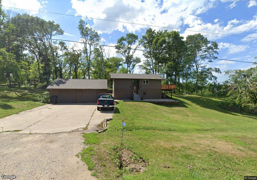
1315 Oak Dr SE Cedar Rapids, IA 52403
Estimated Value: $247,000 - $301,705
4
Beds
2
Baths
1,046
Sq Ft
$260/Sq Ft
Est. Value
About This Home
This home is located at 1315 Oak Dr SE, Cedar Rapids, IA 52403 and is currently estimated at $272,426, approximately $260 per square foot. 1315 Oak Dr SE is a home located in Linn County with nearby schools including Summit Elementary School, Erskine Elementary School, and McKinley STEAM Academy.
Ownership History
Date
Name
Owned For
Owner Type
Purchase Details
Closed on
Oct 29, 1999
Sold by
Gaimari Anton G and Gaimari Adeline M
Bought by
Swyers Jayson Kirk and Street Krista D
Current Estimated Value
Home Financials for this Owner
Home Financials are based on the most recent Mortgage that was taken out on this home.
Original Mortgage
$117,035
Outstanding Balance
$36,057
Interest Rate
7.87%
Mortgage Type
FHA
Estimated Equity
$236,369
Create a Home Valuation Report for This Property
The Home Valuation Report is an in-depth analysis detailing your home's value as well as a comparison with similar homes in the area
Home Values in the Area
Average Home Value in this Area
Purchase History
| Date | Buyer | Sale Price | Title Company |
|---|---|---|---|
| Swyers Jayson Kirk | $117,500 | -- |
Source: Public Records
Mortgage History
| Date | Status | Borrower | Loan Amount |
|---|---|---|---|
| Open | Swyers Jayson Kirk | $117,035 |
Source: Public Records
Tax History Compared to Growth
Tax History
| Year | Tax Paid | Tax Assessment Tax Assessment Total Assessment is a certain percentage of the fair market value that is determined by local assessors to be the total taxable value of land and additions on the property. | Land | Improvement |
|---|---|---|---|---|
| 2025 | $2,940 | $281,400 | $58,200 | $223,200 |
| 2024 | $2,810 | $262,400 | $58,200 | $204,200 |
| 2023 | $2,810 | $262,400 | $58,200 | $204,200 |
| 2022 | $2,764 | $208,100 | $58,200 | $149,900 |
| 2021 | $2,746 | $208,100 | $58,200 | $149,900 |
| 2020 | $2,746 | $191,300 | $44,800 | $146,500 |
| 2019 | $2,530 | $180,400 | $44,800 | $135,600 |
| 2018 | $2,470 | $180,400 | $44,800 | $135,600 |
| 2017 | $2,452 | $171,500 | $44,800 | $126,700 |
| 2016 | $2,518 | $171,500 | $44,800 | $126,700 |
| 2015 | $2,530 | $171,500 | $44,800 | $126,700 |
| 2014 | $2,402 | $171,500 | $44,800 | $126,700 |
| 2013 | $2,352 | $171,500 | $44,800 | $126,700 |
Source: Public Records
Map
Nearby Homes
- Lot 29 Kestrel Heights SE
- Lot 30 Kestrel Heights
- Lot 33 Kestrel Heights
- Lot 35 Kestrel Heights
- Lot 29 Kestrel Heights
- Lot 31 Kestrel Heights
- 1223 Vernon Hill Blvd
- 1209 Rose St
- 921 Rosedale Rd SE
- 827 Tumble Grass Ct SE
- 819 Tumble Grass Ct SE
- 5750 Meadow Grass Cir SE
- 6936 Hackberry Loop
- 6932 Hackberry Loop
- 6849 Pumpkin Patch Blvd
- 6485 Cabbage Patch Place
- 6876 Bottom Land Ln
- 6859 Pumpkin Patch Blvd
- 6934 Hackberry Loop
- 5658 Meadow Grass Cir SE
- 1311 Oak Dr SE
- 1319 Oak Dr SE
- 1314 Oak Dr SE
- 1318 Oak Dr SE
- 6200 Highview Dr SE
- 1310 Oak Dr SE
- 1340 Bertram Rd SE
- 1340 Bertram Rd SE
- 6209 Berry Rd SE
- 6216 Highview Dr SE
- 1500 Bertram Rd SE
- 1307 Oak Dr SE
- 6201 Highview Dr SE
- 6208 Highview Dr SE
- 6205 Highview Dr SE
- 1306 Bertram Rd SE
- 6204 Berry Rd SE
- 6209 Highview Dr SE
- 1510 Bertram Rd SE
- 6221 Highview Dr SE