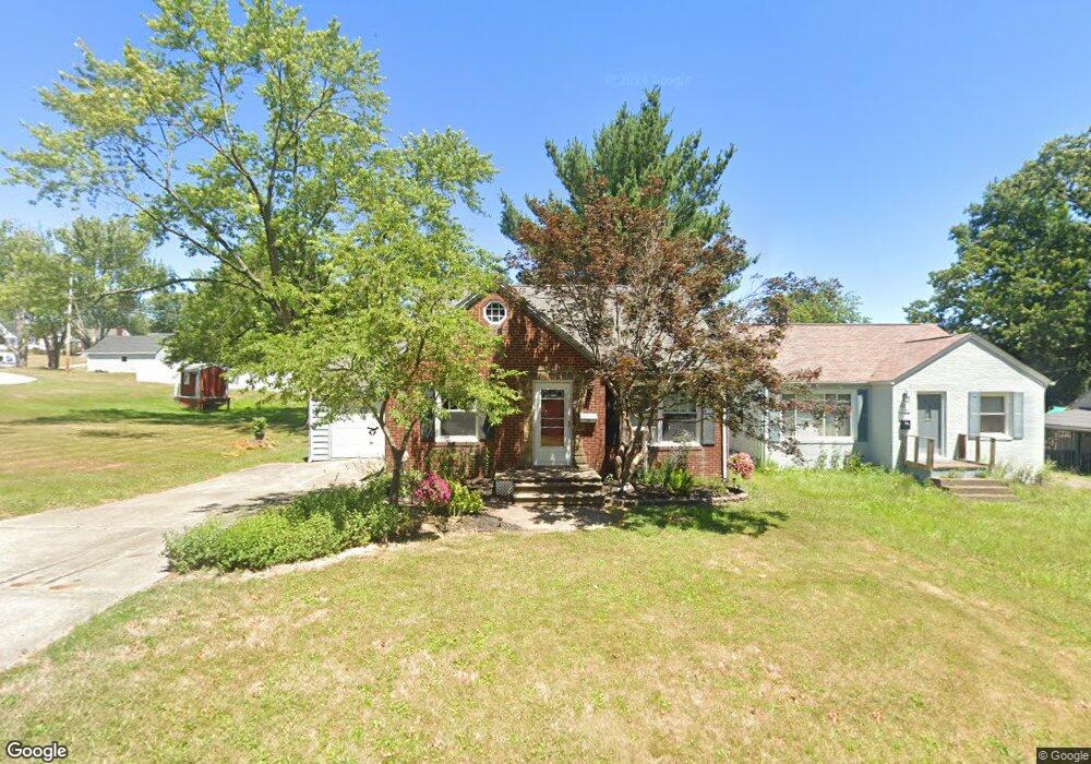
1317 29th St NE Canton, OH 44714
Colonial Heights NeighborhoodEstimated Value: $109,000 - $136,000
2
Beds
1
Bath
912
Sq Ft
$139/Sq Ft
Est. Value
About This Home
This home is located at 1317 29th St NE, Canton, OH 44714 and is currently estimated at $126,482, approximately $138 per square foot. 1317 29th St NE is a home located in Stark County with nearby schools including Frazer Elementary School, Glenwood Intermediate School, and GlenOak High School.
Ownership History
Date
Name
Owned For
Owner Type
Purchase Details
Closed on
Jan 2, 2013
Sold by
Weisel Roland L and Weisel Juanita S
Bought by
Weisel Anthony T
Current Estimated Value
Purchase Details
Closed on
Sep 29, 2009
Sold by
Weisel Roland L and Weisel Juanita S
Bought by
Weisel Roland L and Weisel Juanita S
Purchase Details
Closed on
Sep 10, 2001
Sold by
Metheney Darla S
Bought by
Weisel Roland L and Weisel Juanita S
Purchase Details
Closed on
Jan 26, 2001
Sold by
Metheney John V
Bought by
Metheney Darla S
Purchase Details
Closed on
Dec 26, 1990
Create a Home Valuation Report for This Property
The Home Valuation Report is an in-depth analysis detailing your home's value as well as a comparison with similar homes in the area
Home Values in the Area
Average Home Value in this Area
Purchase History
| Date | Buyer | Sale Price | Title Company |
|---|---|---|---|
| Weisel Anthony T | -- | None Available | |
| Weisel Roland L | -- | None Available | |
| Weisel Roland L | $50,000 | -- | |
| Metheney Darla S | -- | -- | |
| -- | $30,500 | -- |
Source: Public Records
Tax History Compared to Growth
Tax History
| Year | Tax Paid | Tax Assessment Tax Assessment Total Assessment is a certain percentage of the fair market value that is determined by local assessors to be the total taxable value of land and additions on the property. | Land | Improvement |
|---|---|---|---|---|
| 2025 | -- | $34,060 | $9,000 | $25,060 |
| 2024 | -- | $34,060 | $9,000 | $25,060 |
| 2023 | $1,231 | $26,400 | $7,670 | $18,730 |
| 2022 | $1,239 | $26,400 | $7,670 | $18,730 |
| 2021 | $1,245 | $26,400 | $7,670 | $18,730 |
| 2020 | $1,188 | $22,930 | $6,620 | $16,310 |
| 2019 | $1,178 | $22,930 | $6,620 | $16,310 |
| 2018 | $1,164 | $22,930 | $6,620 | $16,310 |
| 2017 | $1,200 | $21,710 | $7,250 | $14,460 |
| 2016 | $1,210 | $21,850 | $7,250 | $14,600 |
| 2015 | $1,170 | $21,850 | $7,250 | $14,600 |
| 2014 | $1,051 | $19,180 | $6,370 | $12,810 |
| 2013 | $514 | $19,180 | $6,370 | $12,810 |
Source: Public Records
Map
Nearby Homes
- 1233 29th St NE
- 000 Rowland Ave NE
- 1306 Milford St NE
- 1202 28th St NE
- 1321 Warrick Place NE
- 1115 Colonial Blvd NE
- 1007 27th St NE
- 808 29th St NE
- 1638 Warrick Place NE
- 1220 25th St NE
- 2510 Gross Ave NE
- 708 29th St NE
- 1227 33rd St NE
- 2219 Rowland Ave NE
- 3321 Martindale Rd NE
- 1624 34th St NE
- 2315 Maple Ave NE
- 2310 Maple Ave NE
- 1513 22nd St NE
- 0 Rowland Ave NE Unit 5089960
- 1323 29th St NE
- 1303 29th St NE
- 1327 29th St NE
- 1316 Spangler Rd NE
- 1320 Spangler Rd NE
- 1333 29th St NE
- 1312 Spangler Rd NE
- 1326 Spangler Rd NE
- 1300 Spangler Rd NE
- 1330 Spangler Rd NE
- 1312 29th St NE
- 1330 29th St NE
- 1403 1429 29th St NE
- 1403 29th St NE
- 1402 Spangler Rd NE
- 1304 29th St NE
- 1230 Spangler Rd NE
- 1410 Spangler Rd NE
- 1225 29th St NE
- 2817 Rowland Ave NE