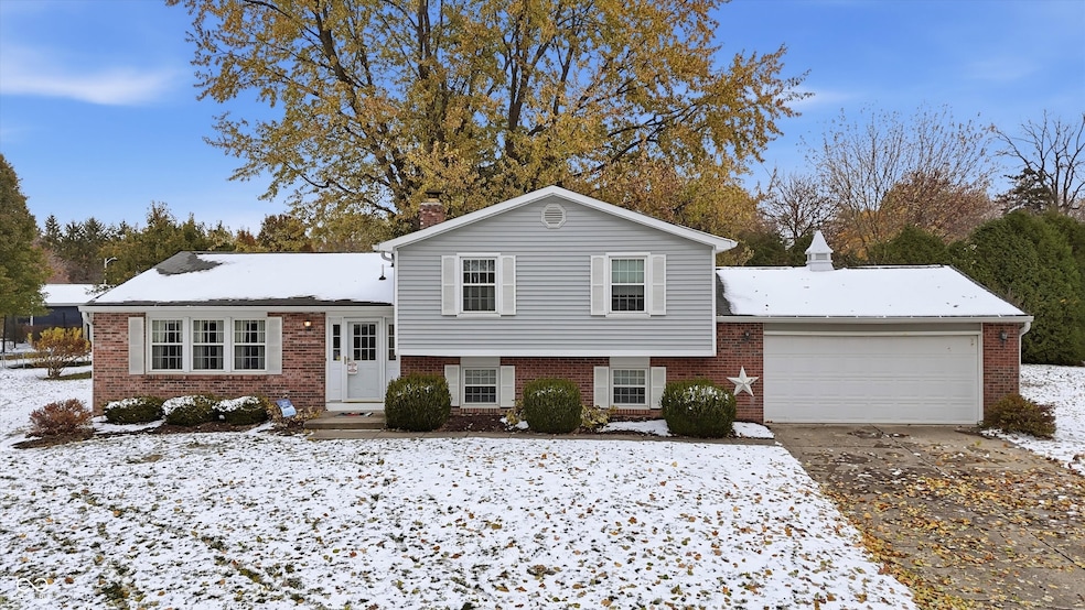


1319 Dogwood Ct Brownsburg, IN 46112
Estimated payment $1,846/month
Highlights
- Updated Kitchen
- Mature Trees
- Marble Flooring
- White Lick Elementary School Rated A+
- Deck
- Main Floor Bedroom
About This Home
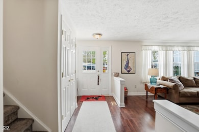
Welcome to this lovingly maintained tri-level in Brownswood Estates-a home that has been cherished by the original owners since it was built in 1977. Tucked away at the top of a quiet cul-de-sac, this property radiates warmth, care, and character throughout. Step inside to find a bright and spacious living room with large windows that fill the space with natural light. The updated flooring flows throughout the main levels, complementing the home's timeless charm. The kitchen features white cabinetry, plenty of counter space, a gas range, and a cheerful eat-in breakfast nook. There's also a fantastic pantry for extra storage. Just off the kitchen, the dining room opens to a large deck overlooking the tree-lined backyard that is perfect for relaxing or entertaining. Upstairs, you'll find three comfortable bedrooms and a full bath complete with double sinks and ample storage. Downstairs, the cozy family room centers around a beautiful brick, wood-burning fireplace-the perfect spot to unwind on cool evenings. A fourth bedroom or office space, a second full bath, and a spacious laundry/utility area provide plenty of flexibility for your needs. Additional updates include a sump pump in the crawlspace, newer flooring throughout, and well-maintained mechanical systems. The exterior features classic brick and siding, mature trees, and a two-car garage. This home has been lovingly cared for by one family for nearly five decades and it shows. Now, it's ready for new owners to make it their own and begin a new chapter filled with warmth, comfort, and lasting memories. Welcome home.
Home Details
Home Type
- Single Family
Est. Annual Taxes
- $2,708
Year Built
- Built in 1977 | Remodeled
Lot Details
- 9,583 Sq Ft Lot
- Cul-De-Sac
- Irregular Lot
- Mature Trees
Parking
- 2 Car Attached Garage
Home Design
- Split Level Home
- Block Foundation
- Vinyl Construction Material
Interior Spaces
- 3-Story Property
- Wood Burning Fireplace
- Fireplace Features Masonry
- Pull Down Stairs to Attic
- Fire and Smoke Detector
Kitchen
- Updated Kitchen
- Breakfast Area or Nook
- Eat-In Kitchen
- Gas Oven
- Built-In Microwave
- Dishwasher
- Disposal
Flooring
- Engineered Wood
- Carpet
- Marble
Bedrooms and Bathrooms
- 4 Bedrooms
- Main Floor Bedroom
Basement
- Sump Pump
- Laundry in Basement
Outdoor Features
- Deck
- Patio
Schools
- White Lick Elementary School
- Brownsburg West Middle School
- Brownsburg High School
Utilities
- Central Air
- Heating System Uses Natural Gas
- Water Heater
Community Details
- No Home Owners Association
- Brownswood Estates Subdivision
Listing and Financial Details
- Legal Lot and Block 147 / 2
- Assessor Parcel Number 320714485006000016
Map
Home Values in the Area
Average Home Value in this Area
Tax History
| Year | Tax Paid | Tax Assessment Tax Assessment Total Assessment is a certain percentage of the fair market value that is determined by local assessors to be the total taxable value of land and additions on the property. | Land | Improvement |
|---|---|---|---|---|
| 2024 | $2,708 | $270,800 | $40,400 | $230,400 |
| 2023 | $2,461 | $246,100 | $36,600 | $209,500 |
| 2022 | $2,339 | $233,900 | $34,800 | $199,100 |
| 2021 | $2,052 | $205,200 | $32,900 | $172,300 |
| 2020 | $1,843 | $184,300 | $32,900 | $151,400 |
| 2019 | $1,676 | $167,600 | $29,800 | $137,800 |
| 2018 | $1,627 | $162,700 | $29,800 | $132,900 |
| 2017 | $1,547 | $154,700 | $28,600 | $126,100 |
| 2016 | $1,488 | $148,800 | $28,600 | $120,200 |
| 2014 | $1,432 | $143,200 | $27,200 | $116,000 |
Property History
| Date | Event | Price | List to Sale | Price per Sq Ft |
|---|---|---|---|---|
| 11/25/2025 11/25/25 | Pending | -- | -- | -- |
| 11/20/2025 11/20/25 | Price Changed | $309,000 | -3.4% | $181 / Sq Ft |
| 11/13/2025 11/13/25 | For Sale | $320,000 | -- | $187 / Sq Ft |
Purchase History
| Date | Type | Sale Price | Title Company |
|---|---|---|---|
| Warranty Deed | -- | None Listed On Document | |
| Warranty Deed | -- | -- |
Source: MIBOR Broker Listing Cooperative®
MLS Number: 22072867
APN: 32-07-14-485-006.000-016
Disclaimer: Certain information contained herein is derived from information provided by parties other than Homes.com. All information provided is deemed reliable, but is not guaranteed to be accurate and should be independently verified.
![]() Based on information submitted to the MLS GRID. All data is obtained from various sources and may not have been verified by broker or MLS GRID. Supplied Open House Information is subject to change without notice. All information should be independently reviewed and verified for accuracy. Properties may or may not be listed by the office/agent presenting the information. Some IDX listings have been excluded from this website.
Based on information submitted to the MLS GRID. All data is obtained from various sources and may not have been verified by broker or MLS GRID. Supplied Open House Information is subject to change without notice. All information should be independently reviewed and verified for accuracy. Properties may or may not be listed by the office/agent presenting the information. Some IDX listings have been excluded from this website.
- 56 Presidential Way
- 29 Robinwood Dr
- 35 Robinwood Dr
- 1127 Statesman Dr
- 1617 Cottongrass Dr
- 390 Vinewood Dr N
- 370 Vinewood Dr S
- 2 Lacy Ct
- 1010 Lakewood North Dr
- 756 Maple Ln
- 1030 Woodridge Unit 52
- 7643 Sagamore Dr
- 747 Homestead Way
- 1804 Pine Cone Dr
- 1031 Woodridge
- 1139 Brunes Blvd Unit 139
- 202 Sugar Bush Ln S
- 4 Kimbrough Ct
- 8542 Goldfinch Rd
- 1247 Holiday Ln E
