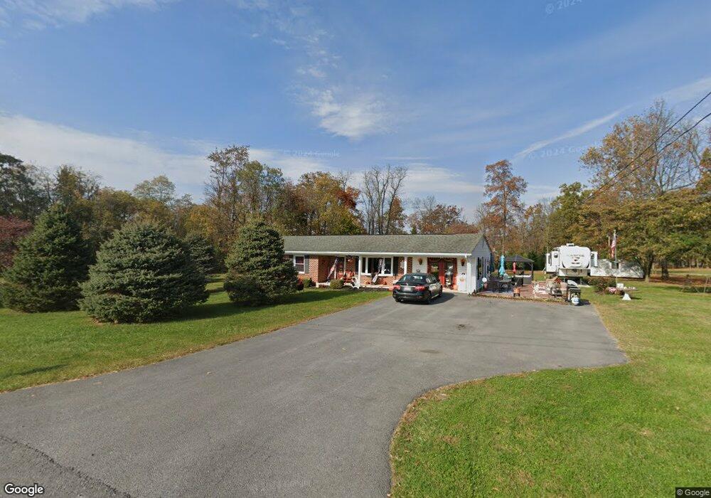
1321 Currie Rd Ranson, WV 25438
Estimated Value: $302,000 - $383,625
3
Beds
2
Baths
1,682
Sq Ft
$207/Sq Ft
Est. Value
About This Home
This home is located at 1321 Currie Rd, Ranson, WV 25438 and is currently estimated at $347,656, approximately $206 per square foot. 1321 Currie Rd is a home located in Jefferson County with nearby schools including T.A. Lowery Elementary School, Wildwood Middle School, and Jefferson High School.
Ownership History
Date
Name
Owned For
Owner Type
Purchase Details
Closed on
Sep 4, 2013
Sold by
Bast Gerald D and Bast Mary Ann
Bought by
Titus Larry M and Bast Titus Katherine Mariah
Current Estimated Value
Home Financials for this Owner
Home Financials are based on the most recent Mortgage that was taken out on this home.
Original Mortgage
$55,000
Interest Rate
4.42%
Mortgage Type
New Conventional
Purchase Details
Closed on
Jan 20, 2005
Sold by
Bast Gerald D and Bast Mary Ann
Bought by
Bast Gerald D and Bast Mary Ann
Create a Home Valuation Report for This Property
The Home Valuation Report is an in-depth analysis detailing your home's value as well as a comparison with similar homes in the area
Home Values in the Area
Average Home Value in this Area
Purchase History
| Date | Buyer | Sale Price | Title Company |
|---|---|---|---|
| Titus Larry M | -- | Equity National Title Insura | |
| Bast Gerald D | -- | None Available |
Source: Public Records
Mortgage History
| Date | Status | Borrower | Loan Amount |
|---|---|---|---|
| Closed | Titus Larry M | $55,000 |
Source: Public Records
Tax History Compared to Growth
Tax History
| Year | Tax Paid | Tax Assessment Tax Assessment Total Assessment is a certain percentage of the fair market value that is determined by local assessors to be the total taxable value of land and additions on the property. | Land | Improvement |
|---|---|---|---|---|
| 2024 | $1,735 | $148,200 | $50,400 | $97,800 |
| 2023 | $1,731 | $148,200 | $50,400 | $97,800 |
| 2022 | $1,554 | $130,400 | $47,200 | $83,200 |
| 2021 | $1,430 | $117,700 | $44,000 | $73,700 |
| 2020 | $1,333 | $117,100 | $42,400 | $74,700 |
| 2019 | $1,338 | $115,400 | $40,700 | $74,700 |
| 2018 | $1,318 | $112,200 | $39,100 | $73,100 |
| 2017 | $1,283 | $109,200 | $35,900 | $73,300 |
| 2016 | $1,258 | $107,400 | $40,100 | $67,300 |
| 2015 | $1,217 | $103,300 | $40,100 | $63,200 |
| 2014 | $893 | $76,000 | $30,900 | $45,100 |
Source: Public Records
Map
Nearby Homes
- 0 Currie Road Rt 9 and Mildred St Unit WVJF2016654
- 0 Currie Rd
- 133 Peters Ave
- Lot 2 War Admiral Blvd
- 34 Coolidge Ave
- 438 Thistle Ridge Ln
- 91 Thornton Ave
- 82 Thornton Ave
- 70 Thornton Ave
- 67 Thornton Ave
- 91 Cecily Way
- 55 Fuzzy Tail Dr
- 151 Peter Rabbit Dr
- Lot 296 Townhomes
- 0 Edgefield Cir
- 375 Anthem St
- 363 Anthem St
- 11 Taft Ave
- 327 Anthem St
- 351 Anthem St
- 80 Basset Ln
- 1355 Currie Rd
- 5 Basset Ln
- 1 Basset Ln
- 98 Basset Ln
- 1231 Currie Rd
- 1423 Currie Rd
- 168 Basset Ln
- 1495 Currie Rd
- 218 Basset Ln
- 1523 Currie Rd
- 401 South S
- 406 East E
- 1330 North N
- 0 E Fifth Ave Unit JF7148722
- 183 Fifth Ave
- 0 E Fifth Ave Unit 1008923702
- 2 Basset Ln
- 0 War Admiral Blvd
- 0 Basset Ln Unit JF10035091